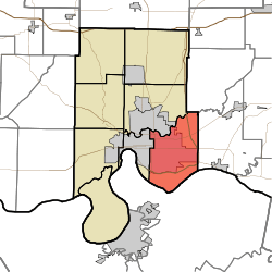
Knight Township, Vanderburgh County, Indiana
Knight Township is one of eight townships in Vanderburgh County, Indiana, USA. As of the 2010 census, its population was 67,945 and it contained 33,472 housing units.[1] Knight Township has the largest township population in Southwestern Indiana and is the home of nearly 40 percent of Vanderburgh County's population. On October 1, 2009, the City of Evansville officially annexed territory within Knight Township bounded between Burkhardt Road, the Lloyd Expressway and Morgan Avenue.
Geography
According to the 2010 census, the township has a total area of 34.79 square miles (90.1 km2), of which 34.19 square miles (88.6 km2) (or 98.28%) is land and 0.6 square miles (1.6 km2) (or 1.72%) is water.[1]
Cities, towns, villages
Adjacent townships
- Indiana
- Vanderburgh County
- Warrick County
Cemeteries
The township contains these two cemeteries: Oak Hill and Oates Memorial Park.
Airports and landing strips
- Saint Marys Medical Center Airport
Lakes
Landmarks
School districts
- Evansville-Vanderburgh School Corporation
Political districts
- Indiana's 8th congressional district
- State House District 75
- State House District 77
- State House District 78
- State Senate District 49
- State Senate District 50
- Evansville City Ward 1
- Evansville City Ward 2
- Evansville City Ward 3
- Evansville City Ward 4
- Evansville City Ward 5
References
- ↑ 1.0 1.1 "Population, Housing Units, Area, and Density: 2010 - County -- County Subdivision and Place -- 2010 Census Summary File 1". United States Census. Retrieved 2013-05-10.
External links
|
|---|
| | Annual Festivals | |
|---|
| | Arenas and Venues | |
|---|
| Corporate Headquarters
and Major Employers | |
|---|
| | Education | |
|---|
| | Neighborhoods / Districts | |
|---|
| | Attractions | |
|---|
| | Malls & Other Commerce | |
|---|
| | Sports | |
|---|
| | Transportation | |
|---|
| | Healthcare & Emergency | |
|---|
| | Regional | |
|---|
|


