Kleve
| Cleves | ||
|---|---|---|
|
Night view of Schwanenburg and Stiftkirche | ||
| ||
 Cleves | ||
Location of Cleves within Kleve district 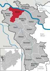
 | ||
| Coordinates: 51°47′15″N 6°8′7″E / 51.78750°N 6.13528°ECoordinates: 51°47′15″N 6°8′7″E / 51.78750°N 6.13528°E | ||
| Country | Germany | |
| State | North Rhine-Westphalia | |
| Admin. region | Düsseldorf | |
| District | Kleve | |
| Government | ||
| • Mayor | Theodor Brauer (CDU) | |
| Area | ||
| • Total | 97.79 km2 (37.76 sq mi) | |
| Population (2013-12-31)[1] | ||
| • Total | 48,172 | |
| • Density | 490/km2 (1,300/sq mi) | |
| Time zone | CET/CEST (UTC+1/+2) | |
| Postal codes | 47533 | |
| Dialling codes | 0 28 21 | |
| Vehicle registration | KLE | |
| Website | www.kleve.de | |


Cleves (German: Kleve, Cleves Dutch: Kleff, Dutch: Kleef, French: Clèves, Latin: Clivia), is a town in the Lower Rhine region of northwestern Germany near the Dutch border and the River Rhine. From the 11th century onwards, Cleves was capital of a county and later a duchy. Today, Cleves is the capital of the district of Cleves in the German state of North Rhine-Westphalia.
Division of the town
Cleves consists of 14 subdivisions:
Bimmen, Brienen, Donsbrüggen, Düffelward, Griethausen, Keeken, Kellen, Materborn, Reichswalde, Rindern, Salmorth, Schenkenschanz, Warbeyen and Wardhausen.
-

Bimmen, church: Sankt Martinuskirche
-

Düffelward, church
-

Keeken, catholic church
-

Warbeyen, church: Sankt Hermeskirche
History

.jpg)
The native name Kleff probably derives from Middle Dutch clef, clif ‘cliff, bluff’, referring to the promontory on which the Schwanenburg castle was constructed. Since the city's coat of arms displays three clovers (German Klee, Low German Kliev), the city's name is sometimes linked by folk etymology to the clover, but the corresponding Dutch word is klever.[2] Notably, Kleve was spelled with a c throughout its history until spelling reforms introduced in the 1930s required that the name be spelled with a k. As of 2008, the CDU announced ambitions to return the name to its original spelling.
The Schwanenburg (English: Swan Castle), where the dukes of Cleves resided, was founded on a steep hill. It is located at the northern terminus of the Kermisdahl where it joins with the Spoykanal, which was previously an important transportation link to the Rhine. The old castle has a massive tower, the Schwanenturm 180 feet (55 m) high, that is associated in legend with the Knight of the Swan, immortalized in Richard Wagner's Lohengrin.
Medieval Kleve grew together from four parts — the Castle Schwanenburg, the village below the castle, the first city of Kleve on the Heideberg Hill, and the Neustadt ("New City") from the 14th century. In 1242 Kleve received city rights. The Duchy of Cleves, which roughly covered today's districts of Kleve, Wesel and Duisburg, was united with the Duchy of Mark in 1368, was made a duchy itself in 1417, and then united with the neighboring duchies of Jülich and Berg in 1521, when John III, Duke of Cleves, married Mary, the heiress of Jülich-Berg-Ravenburg.
Kleve's most famous native is Anne of Cleves (1515–1557), daughter of John III, Duke of Cleves and (briefly) wife of Henry VIII of England. Several local businesses are named after her, including the Anne von Kleve Galerie.
The local line became extinct in the male line in 1609, leading to a succession crisis in the duchies. After the Thirty Years' War, in 1648, the succession dispute was finally resolved with Cleves passing to the elector of Brandenburg, thus becoming an exclave of the territory of Prussia.
During the Thirty Years' War the city had been under the control of the Dutch Republic, which in 1647 had given Johann Moritz von Nassau-Siegen administrative control over the city. He approved a renovation of the Schwanenburg in the baroque style and commissioned the construction of extensive gardens that greatly influenced European landscape design of the 17th century. Significant amounts of his original plan for Kleve were put into effect and have been maintained to the present, a particularly well-loved example of which is the Forstgarten.
The mineral waters of Kleve and the wooded parkland surrounding it made it a fashionable spa in the 19th century. At this time, Kleve was named "Bad Cleve" (English "baths of cleves"). Kleve has long since lost its reputation as a fashionable getaway, though tourism remains a significant factor in the local economy.
During the early part of WW2 the town was the location for one of the Knickebein transmitters for the night bombing navigation system used to attack Great Britain,[3] it being one of the German locations closest by line of site to Great Britain. Luftwaffe bombers would fly along the beam until it was intersected by a cross beam from another similar transmitter in e.g. Denmark.
Kleve suffered heavy bombing during the Second World War, with over 90% of buildings in the city severely damaged. As a result, relatively little of the pre-1945 City remains, although many historic villas built by wealthy German vacationers from the Ruhrgebiet during the heyday of Bad Kleve still stand along the B9 near the Tiergarten. Many buildings were reconstructed, however, including most of the Schwanenburg and the Stiftskirche, the Catholic parish church. These landmarks, constructed on some of the highest land in the surrounding area, can be seen from many surrounding communities.
Since 1953 there has been a broadcasting facility for FM radio and television from regional broadcaster WDR near Kleve. It uses as aerial mast a 126.4 metre high guyed steel tube mast with a diameter of 1.6 metres, which is guyed 57 and 101.6 metres above ground. This mast replaced the old radio mast from the 1960s, which was used until 1993, additionally for transmissions in the medium wave range.
Important employers in the area associated with the Wirtschaftswunder after the war were the XOX Bisquitfabrik (XOX Cookie Factory) GmbH and the Van den Berg'schen Margerinewerke (Margarine Union), that manufactured cookies and margarine. Another important employer was the Elefanten-Kinderschuhfabrik (Elefant Children's Shoes Factory). All of these businesses have since closed. Retail has become an increasingly important industry, particularly after the institution of the Euro. Local retailers are often visited by Dutch drawn by significantly lower prices. 1 out of every 2 Euros spent in Kleve originate from The Netherlands. Many Dutch citizens also own homes in the area, attracted by significantly lower real estate prices. Sizeable Dutch communities exist in the area around Kranenburg to the west of Kleve. Most of them do not work in Germany, but commute from there to Nijmegen, situated directly across the border.
Language and dialect
The native language of Cleves and much of the Lower Rhine region is a Dutch dialect known as Cleverlander (Dutch: Kleverlands, German: Kleverländisch), most closely related to South Guelder, but the official language is German which is dominant among the younger generation. Because of its geographical location directly at the Dutch-German border, there is a strong overlap in culture and language. One example of this is Govert Flinck, who although born in Cleves, established himself as a Dutch artist.
Twin cities
Kleve is twinned with
-
.svg.png) Ronse (Belgium)
Ronse (Belgium) -
 Fitchburg, Massachusetts (USA)
 -
 Worcester (UK)
See also
- Anne of Cleves
- Marie of Cleves
- Joachim Murat of the Napoleonic years.
- Duke Englebert of Cleves, Count of Nevers
- Joseph Beuys (artist) grew up in Kleve.
- Jean-Baptiste du Val-de-Grâce, baron de Cloots born in Kleve.
References
- ↑ "Amtliche Bevölkerungszahlen". Landesbetrieb Information und Technik NRW (in German). 4 September 2014.
- ↑ L. Grootaers & G.G. Kloeke, eds., Taalatlas van Noord- en Zuid-Nederland (Leiden: E.J. Brill, 1939): .
- ↑ Most Secret War. R.v. jones
External links
| Wikimedia Commons has media related to Kleve. |
- Official site
- Tourist Information
- Edicts of Jülich, Cleves, Berg, Grand Duchy Berg, 1475-1815 (Coll. Scotti) online
- Settlement of Dortmund between Brandenburg and Palatinate-Neuburg and the conflict of succession in Jülich, in full text
| ||||||||