Kiyokawa, Kanagawa
| Kiyokawa 清川村 | |||
|---|---|---|---|
| Village | |||
|
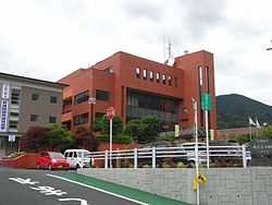
KIyokawa Village Hall | |||
| |||
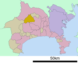 Location of Kiyokawa in Kanagawa Prefecture | |||
 Kiyokawa
| |||
| Coordinates: 35°28′56″N 139°16′35″E / 35.48222°N 139.27639°ECoordinates: 35°28′56″N 139°16′35″E / 35.48222°N 139.27639°E | |||
| Country | Japan | ||
| Region | Kantō | ||
| Prefecture | Kanagawa Prefecture | ||
| District | Aikō | ||
| Area | |||
| • Total | 71.29 km2 (27.53 sq mi) | ||
| Population (June 1, 2012) | |||
| • Total | 3,359 | ||
| • Density | 47.1/km2 (122/sq mi) | ||
| Time zone | Japan Standard Time (UTC+9) | ||
| - Tree | Maple | ||
| - Flower | Rhododendron | ||
| - Bird | Japanese Bush-warbler | ||
| Phone number | 046-288-1211 | ||
| Address |
2216 Susugaya, Kiyokawa-mura, Aikō-gun, Kanagawa-ken 243-0195 | ||
| Website | Village of Kiyokawa | ||


Kiyokawa (清川村 Kiyokawa-mura) is a village located in Aikō District, Kanagawa Prefecture, Japan. As of June 2012, the village had an estimated population of 3,359 and a population density of 47.1 persons per km². The total area is 71.29 km².
Geography
Kiyokawa is located in the foothills of northwestern Kanagawa Prefecture. Much of the village is in the Tanzawa Mountains.
Surrounding municipalities
History
Kiyokawa Village was established on September 30, 1956 through the merger of former Susugaya and Miyagase villages. The completion of the Miyagase Dam in 1965 submerged much of former Miyagase Village, forcing the relocation of its inhabitants to other locations within Kiyokawa Village and neighboring Aikawa Town.
Transportation
Kiyokawa has no connections with the Japanese national highway or railway systems. Access is by Kanagawa Prefectural Routes 60, 64, 70 or 514.
Noted people from Kiyokawa
- Hitoshi Tamura - professional baseball player
External links
- Official website in Japanese
| Wikimedia Commons has media related to Kiyokawa, Kanagawa. |
| ||||||||||||||||||||||||||||||||||||||||||||||||||||||