Kitamoto, Saitama
| Kitamoto 北本市 | ||
|---|---|---|
| City | ||
|
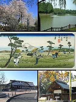
Top left: Ishidokaba Cherry blossom in Toko Temple, Top right: A fountain in Kitamoto General Park, Center: Konosu Traditional Inn, Nakasen Road in Edo period, Bottom left: Kitamoto Station, Bottom right: Tenjinchigi Shrine | ||
| ||
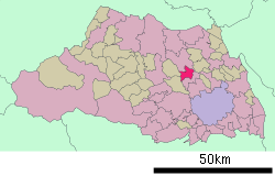 Location of Kitamoto in Saitama Prefecture | ||
 Kitamoto Location in Japan | ||
| Coordinates: 36°01′26″N 139°32′01″E / 36.02389°N 139.53361°ECoordinates: 36°01′26″N 139°32′01″E / 36.02389°N 139.53361°E | ||
| Country | Japan | |
| Region | Kantō | |
| Prefecture | Saitama Prefecture | |
| Government | ||
| • Mayor | Kenji Ishizu (since May 2003) | |
| Area | ||
| • Total | 19.84 km2 (7.66 sq mi) | |
| Population (June 1, 2011) | ||
| • Total | 69,984 | |
| • Density | 3,527.42/km2 (9,136.0/sq mi) | |
| Time zone | Japan Standard Time (UTC+9) | |
| Symbols | ||
| - Tree | Cherry blossom | |
| - Flower | Chrysanthemum | |
| Address |
1-111 Honmachi, Kitamoto-shi, Saitama-ken 364-8633 | |
| Phone number | 048-591-1111 | |
| Website |
www | |

Kitamoto (北本市 Kitamoto-shi) is a city located in Saitama Prefecture, Japan. The city was founded on November 3, 1971.
As of June 1, 2011, the city has an estimated population of 70,237, with 27,714 households and a population density of 3,527.42 persons per km². The total area is 19.84 km².
Transportation
Rail
Road
International relations
Twin towns — Sister cities
Kitamoto has been twinned with Aizubange, Fukushima in Japan since 1992.
External links
- Kitamoto City official website (Japanese)
| |||||||||||||||||||||||||