Kiso River
| Kiso River | |
|---|---|
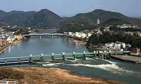 Kiso River and bridge (Inuyamatoushukourain'oohashi) seen from Mount Igi. | |
| Origin | Mount Hachimori |
| Mouth | Ise Bay |
| Basin countries | Japan |
| Length | 229 km (142 mi) |
| Source elevation | 2,446 m (8,025 ft) |
| Avg. discharge | 169 m3/s (6,000 cu ft/s) at mouth |
| Basin area | 5,275 km2 (2,037 sq mi) |
| River system | Kiso River |
The Kiso River (木曽川 Kiso-gawa) is a river in Japan roughly 229 km long, flowing through the prefectures of Nagano, Gifu, Aichi, and Mie before emptying into Ise Bay a short distance away from the city of Nagoya.[1] It is the main river of the Kiso Three Rivers (along with Ibi and Nagara rivers) and forms a major part of the Nōbi Plain. The valley around the upper portion of the river forms the Kiso Valley.
Parts of the Kiso River are sometimes referred to as the Japan Rhine because of its similarities to the Rhine in Europe.
See also
Notes
- ↑ Nussbaum, Louis Frédéric et al. (2005). "Kiso-gawa" in Japan encyclopedia, p. 529., p. 529, at Google Books; n.b., Louis-Frédéric is pseudonym of Louis-Frédéric Nussbaum, see Deutsche Nationalbibliothek Authority File.
References
- Nussbaum, Louis Frédéric and Käthe Roth. (2005). Japan Encyclopedia. Cambridge: Harvard University Press. 10-ISBN 0-674-01753-6; 13-ISBN 978-0-674-01753-5; OCLC 48943301
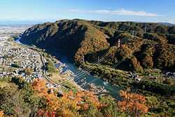
Japan Rhine seen from Sarubami Castle
External links
- Kisogawa River Sand Data — a Japan Agency for Marine-Earth Science and Technology−JAMSTEC]] website
| Wikimedia Commons has media related to Kiso River. |
35°02′04″N 136°44′43″E / 35.034563°N 136.745333°ECoordinates: 35°02′04″N 136°44′43″E / 35.034563°N 136.745333°E (mouth)