Kirovskyi District, Dnipropetrovsk
| Kirovskyi District Кіровський район | |
|---|---|
| Urban district | |
 Map of the urban districts of Dnipropetrovsk. | |
| Coordinates: 48°28′00″N 35°02′00″E / 48.46667°N 35.03333°ECoordinates: 48°28′00″N 35°02′00″E / 48.46667°N 35.03333°E | |
| Country |
|
| Municipality | Dnipropetrovsk Municipality |
| Established | 1932[1] |
| Area[2] | |
| • Total | 10.403 km2 (4.017 sq mi) |
| Population (2001 census) | |
| • Total | 71,115 |
| • Density | 6,800/km2 (18,000/sq mi) |
| Time zone | EET (UTC+2) |
| • Summer (DST) | EEST (UTC+3) |
| Area code | +380 562 |
| KOATUU | 1210137500[3] |
Kirovskyi District (Ukrainian: Кіровський район) is an urban district of the city of Dnipropetrovsk, in southern Ukraine.[4] It is located in the city's center and on the right-bank of the Dnieper River.
It was originally created in 1932 as the Tsentralnyi Nahornyi District, but on 2 December 1934 it was renamed as the Kirovskyi District, a name which it has kept to this day. In 1936 the eastern part of district became the Zhovtnevyi District. In 1973 more territories of the Kirovskyi District were passed to the newly formed Babushkinskyi District.
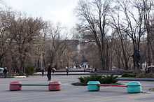
Lazar Hloba Park in Kirovsky District

Modern buildings in central part of Dnipropetrovsk
References
- ↑ "Kirovskyi Raion". Official Internet-portal (in Ukrainian). Dnipropetrovsk City Council. Retrieved 4 February 2015.
- ↑ "Kirovskyi Raion" (in Ukrainian). http://gorod.dp.ua/. Retrieved 4 February 2015.
- ↑ "Kirovskyi District Council". Informational portal of the self-government in Ukraine (in Ukrainian). Rada.info. Retrieved 5 February 2015.
- ↑ "Kirovskyi Raion, Dnipropetrovsk Oblast, City of Dnipropetrovsk". Regions of Ukraine and their Structure (in Ukrainian). Verkhovna Rada of Ukraine. Retrieved 4 February 2015.
External links
- Kirov Raion at the Dnipropetrovsk City Council website
| ||||||||||||||||||||||||||||||||||||