Kirby Muxloe
| Kirby Muxloe | |
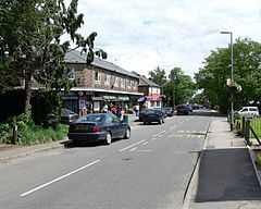 Main Street, Kirby Muxloe |
|
 Kirby Muxloe |
|
| Population | 4,523 [1] |
|---|---|
| OS grid reference | SK519044 |
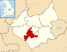
| District | Blaby District |
| Shire county | Leicestershire |
| Region | East Midlands |
| Country | England |
| Sovereign state | United Kingdom |
| Post town | LEICESTER |
| Postcode district | LE9 |
| Dialling code | 0116 |
| EU Parliament | East Midlands |
| UK Parliament | Charnwood |
| Website | http://kirbymuxloe.net/ |
|
|
Coordinates: 52°38′06″N 1°14′03″W / 52.6351°N 1.2341°W
Kirby Muxloe is a [village and civil parish west of Leicester. Its proximity to the city causes it to form part of the Leicester Urban Area. The Leicester Forest East parish border runs along the Hinckley Road A47. According to the 2001 census the parish had a population of 4,523.[2]
History
The name "Kirby" comes from the Dane, Caeri and who established the community here in the late ninth or early tenth century. The settlement was known as Carbi, and then later Kirby.[3] The village was recorded in the Domesday book as 'Carbi'. (Caeri's settlement) with a working population of 8. At the time the land in Kirby Muxloe was owned by Hugh de Grandesmaynel and by William Peverel.[4] In 1461, William Hastings, the 1st Baron Hastings of Hungerford, became the Steward of the Honor of Leicester and Ranger of Leicester Forest. His father, Sir Leonard Hastings, had owned a modest estate in Leicestershire and Gloucestershire, where the family had long been established. On 14 April 1474 Hastings acquired the manorial right to Kirby from the Pakeman family, although he had rented it for some years previous to this. In 1480 he began to build the moated Kirby Muxloe Castle during the period of the Wars of the Roses. However, work on the castle stopped soon after Lord Hastings was executed on 13 June 1483 on the orders of King Richard III at the Tower of London for conspiracy. William was caught up in the rivalry for the throne after the death of Edward IV.[4][5]
In 1582 the name of village becomes Kirby Muckelby, with variants Mullox, Muckle. About 50 years later in 1628 disafforestation of Leicester Forest occurred, effectively dividing the land near Kirby Muxloe into forest and pasture. The results are visible today. In 1636, the Hastings families sold castle and estates in Kirby and Braunstone to the Winstanley family. The first official use of Kirby Muxloe was used in 1703 in the Oxford Dictionary of Placenames, which states that 'Muxloe' is a family name. There was such a family but they lived three miles away, in the village of Desford.
An early Quaker, John Penford, was a substantial resident of Kirby Muxloe and member of the Leicester Quarterly Meeting. A business meeting of the Society held at his home to consult on works of charity in 1670 was interrupted by informers, with the result that Penford and others were heavily fined.[6]
The railway came to Kirby Muxloe in 1848 when the Midland Railway built a line through Kirby, and on 1 July 1859 Kirby Muxloe railway station opened at Kirby fields. In 1882, the fields known as Far and Near Townsend Close were bought by Kirby Muxloe Land Society. Barwell Road, Castle Road, and Church Road were laid out for the village and building went on over the next 30 years.
In 1911, Kirby Muxloe Castle was handed over to Ministry of Works, and later English Heritage. Amidst World War II in 1941 the village was heavily bombed. A German bomber on its way back after attacking Coventry emptied its load on two streets with destruction of a church and several houses. Gaps left in the houses can still be seen to this day. On 7 September 1964 the Kirby Muxloe railway station closed in the Beeching Axe.
The town currently benefits from a local primary school which is rated as one of the top schools in the county. There is a chemist, bakery, supermarket, two pubs, a popular sports and social club and a golf club.
Many people who lived there during the late 20th century were either born in a small maternity home in Station Road, near Barwell Road or in Roundhill Maternity Home (NHS) in Hastings Road, Kirby Fields. Both are now private residences, as they were before they became Maternity Homes. What was the nurses home at the entrance to Roundhill is now also a private residence.
Kirby Muxloe Primary School
The village has a primary school with reception year.
Places of interest
Sports clubs/leisure:
- Kirby Muxloe S.C.
- Kirby Muxloe Cricket Club
- Kirby Muxloe Bowls Club
Location
 |
Botcheston | Ratby | Glenfield | |
| Desford | |
Leicester | ||
| ||||
| | ||||
| Leicester Forest West | Leicester Forest East | Braunstone Town |
References
- ↑ Census, 2001
- ↑ Leicestershire County Council. Census 2001 Parish Profile Retrieved on 19 July 2007
- ↑ About Leicestershire. Kirby Muxloe Castle Retrieved on 19 July 2007
- ↑ 4.0 4.1 Leicestershirevillages.com. Kirby Muxloe Retrieved on 19 July 2007
- ↑ English Heritage. Kirby Muxloe Castle Retrieved on 19 July 2007
- ↑ John Gough, A History of the People Called Quakers (Robert Jackson, Dublin 1790), II, p. 314. read here For local context see R.H. Evans, 'The Quakers of Leicestershire', Leicester Archaeological and Historical Society XXVIII, pp. 63-83. read here
External links
| Wikimedia Commons has media related to Kirby Muxloe. |
- Kirby Muxloe Free Church
- St Bartholomew's Church
- Kirby Muxloe Archery Club
- Kirby Muxloe Primary School
| ||||||||||||||||||||