Kinnikinnick, Ohio
| Kinnikinnick, Ohio | |
|---|---|
| Unincorporated community | |
 Kinnikinnick, Ohio | |
| Coordinates: 39°25′33″N 82°57′10″W / 39.42583°N 82.95278°WCoordinates: 39°25′33″N 82°57′10″W / 39.42583°N 82.95278°W | |
| Country | United States |
| State | Ohio |
| County | Ross |
| Elevation | 666 ft (203 m) |
| Time zone | Eastern (EST) (UTC-5) |
| • Summer (DST) | EDT (UTC-4) |
| Area code(s) | 740 |
| GNIS feature ID | 1058188[1] |
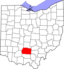
Kinnikinnick is an unincorporated community in Ross County, Ohio, United States. Kinnikinnick is located at the junction of Ohio State Route 159 and Ohio State Route 180 16.6 miles (26.7 km) north-northeast of Chillicothe.[2]
The community was named for the Native American tobacco product kinnikinnick.[3]
Gallery
-
Kinnikinnick community sign.
-
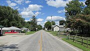
Looking east on Ohio Highway 180 in Kinnikinnick.
References
- ↑ "Kinnikinnick". Geographic Names Information System. United States Geological Survey.
- ↑ Official Transportation Map (PDF) (Map). Ohio Department of Transportation. 2011. Retrieved February 1, 2013.
- ↑ Gannett, Henry (1905). The Origin of Certain Place Names in the United States. Govt. Print. Off. p. 176.
| |||||||||||||||||||||||||||||||||||||


