Kinishba Ruins
|
Kinishba Ruins | |
 | |
|
Kinishba Ruins | |
 | |
| Location | Gila County, Arizona, USA |
|---|---|
| Nearest city | Canyon Day, Arizona |
| Coordinates | 33°48′53″N 110°03′16″W / 33.81472°N 110.05444°WCoordinates: 33°48′53″N 110°03′16″W / 33.81472°N 110.05444°W |
| Architect | Vernacular |
| Architectural style | Ancestral Pueblo |
| Governing body | White Mountain Apache Tribe |
| NRHP Reference # | 66000180 |
| Significant dates | |
| Added to NRHP | October 15, 1966[1] |
| Designated NHL | July 19, 1964[2] |
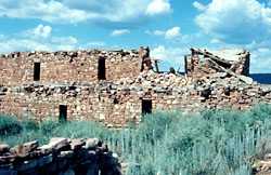
Kinishba Ruins is a sprawling, 600-room great house archaeological site in eastern Arizona and is administered by the Southern Athabaskan-speaking White Mountain Apache Tribe of the nearby Fort Apache Indian Reservation. As it demonstrates a combination of indigenous Mogollon and Anasazi cultural traits, archeologists consider it ancestral to the peoples of both the Hopi and Zuni cultures.[3]
Kinishba is located at 5,000 feet above a pine-fringed alluvial valley, near Whiteriver, Arizona, the seat of government for the White Mountain Apache Tribe. The first European to write about it was Adolph Bandelier in 1892, who was a pioneering archaeologist. From 1931 to 1940, the archeologist Dr. Byron Cummings, Director of the Arizona State Museum and head of the Department of Archeology at the University of Arizona, led a team of archaeology students and Apache over several seasons to excavate and restore Kinishba. He named the site, derived from the Apache words: ki datbaa, meaning "brown house." The teams also built a pueblo-style museum and visitor's center, as Cummings envisioned it as a destination to help with economic development of the area.[3] Cummings hoped Kinishba would be declared a national monument and taken under National Park Service management, but did not succeed in this.
In 1964, the NPS designated the site as a National Historic Landmark, by which time it had fallen into disrepair. The ruins received limited cleanup and restoration in 2005-2007.[3]
Description
Kinishba is located at about 5,000 feet above sea level, south of the Mogollon Rim and north of the Salt River. It is at the eastern foot of Tsé Sizin (“Rock Standing Up” or Sawtooth Mountain), on White Mountain Apache trust lands associated with the Fort Apache Indian Reservation. The reservation is located in the valley that slopes to the White River. The site is the most publicly accessible of the 20 or so large (150 or more rooms), Ancestral Pueblo village ruins in the area.
These were built and occupied as part of the ancient American Indian colonization of the Mogollon Rim region in the AD 1100s to 1300s. They were considered part of the western Pueblo complex.[4] The largest 13th- and 14th-century ruins along the Mogollon Rim all share architectural elements, ceramic assemblages, and similar locational characteristics. They are proximate to expanses of land suitable for dry maize farming, and they have ready access to domestic water, tabular sandstone or limestone, and ponderosa pine.[3]
All of these large villages were built up from apartment-style room blocks, laid out to define communal courtyards or plazas. The Kinishba pueblo is composed of nine major building mounds, the remains of masonry room blocks, with some originally three stories tall. There were two large apartment blocks, and several smaller buildings, with two communal courtyards. At its peak, Kinishba may have housed up to 1000-1500 people. The masonry walls are unique for their double-walled construction: one side is faced and the other made of rubble.[4] The rooms averaged 14' by 12', with a firepit in the center. Scholars believe that most families occupied two rooms, one for living quarters and one for storage.[4]
In the smaller courtyard was a kiva, a room built underground for ceremonies. The larger courtyard revealed evidence of three ceremonial stages. It is 63 by 51 feet. In the first stage, of the late 1100s or early 1200s, five underground rooms, each the size of the kiva, were built; they had earthen rather than masonry walls. About the middle of the 1200s, these rooms were filled in and juniper posts were set into the ground to support beams and a roof, making a large, above-ground room of the courtyard. Later the roof burned, and researchers found no evidence that it was replaced. Ceremonies were moved to other rooms of the pueblo.[4]
The people cultivated corn, beans and gourds nearby, which were raised together to conserve moisture. They may have raised cotton as well, and gathered fruits, berries, nuts and other foods locally. The men hunted game for food, and the women processed the skin, sinew and bones for clothing, tools, and other needs.[4]
Scholars believe that Kinishba may have been the pueblo Chiciticale referred to in narratives of the 1540-41 Spanish expedition led by Francisco Vásquez de Coronado. Kinishba and its sister villages were abandoned in the late 14th or early 15th century for unknown reasons. It may have been related to a water source drying up.[3][4] The area was virtually unoccupied until the 16th or 17th-century migration of nomadic Apache from the western Great Plains. They did not live at the ruins but had territory in the area.[4]
Archeological excavation
Over the years, the site was pulled apart by pot hunters and soldiers from Fort Apache seeking souvenirs. In 1892 Adolph Bandelier, a pioneering archaeologist, was the first European to write about the site, and other archeologists visited it.
From 1931 into the 1940s, Byron Cummings of the University of Arizona led a team of students and a varying workforce of 10-27 White Mountain Apache to excavate and restore the site. Cummings named the site, derived from the Apache words: ki datbaa, meaning "brown house." He created a university field school at the camp of the site, which had seasons from 1931-1939.[3] He used a variety of funding means, including his broad network of supporters and the Civilian Conservation Corps and Bureau of Indian Affairs(which administered the Fort Apache Agency), to pay for workers and materials. Chester Holden, David Kane, and Turner Thompson were Apache men who spent at least five seasons at the site and became strongly attached to the project.[3]
In addition, the teams built a small museum and tourist site in 1939 to hold artifacts and interpret the site, as well as to provide a place to sell contemporary Apache arts and crafts, and to provide continuing employment for tribal members. Cummings was a scholar-entrepreneur, who "combined archaeological research and training; intertribal and interagency collaboration; historic preservation; and museum, community, and tourism enterprise development" in the first project of its kind in Arizona."[3] With his teams, Cummings "excavated at least 220 rooms," and "rebuilt about 140" to create what today is called a heritage tourism destination.[3]
He hoped to have the Department of the Interior designate the site as a National Monument and add it to properties managed by the National Park Service. It gave preference to more accessible sites, given the needs of the Great Depression quickly followed by World War II. Cummings did not succeed in having the NPS take over the site.[3]
In 1956 the Department of the Interior published a pamphlet on the site, referring to the "Kinishba Ruins and Museum".[4] The site was declared a National Historic Landmark in 1964 by the Department of the Interior and added to the National Register of Historic Places.
Since then, the ruins deteriorated without maintenance, as did the museum. A partial restoration was done in 2005-2007 to stabilize much of the site. It is administered by the White Mountain Apache Tribe and the Fort Apache Heritage Foundation as a "satellite" element of the Fort Apache Historic Park.[3] The White Mountain Apache require visitors to obtain a permit to visit the Kinishba Ruins site.
The White Mountain Apache have built their own museum at the Fort Apache Historic Park, based on their traditional style of a gowa, or home. It is called Nohwike’ Bágowa (House of Our Footprints), or the White Mountain Apache Culture Center and Museum.[5] The park includes a 288-acre National Historic District, with 27 buildings from when the fort was used during the Apache Wars. The reservation can provide visitors with standing structures from ancient to contemporary times, and explanations of history of the Mogollon Rim Pueblo, as well as the historic and contemporary White Mountain Apache.
Footnotes
- ↑ "National Register Information System". National Register of Historic Places. National Park Service. 2007-01-23.
- ↑ "Kinishba Ruins". National Historic Landmark summary listing. National Park Service. Retrieved 2007-12-03.
- ↑ 3.0 3.1 3.2 3.3 3.4 3.5 3.6 3.7 3.8 3.9 3.10 Welch, John R. " 'A Monument to Native Civilization': Byron Cummings' Still-Unfolding Vision for Kinishba Ruins", Journal of the Southwest 49 (1): 1-94, 22 March 2007, at Highbeam, accessed 31 July 2011
- ↑ 4.0 4.1 4.2 4.3 4.4 4.5 4.6 4.7 James B. Shaeffer, "Kinishba, A Classic Site of the Western Pueblos", Washington, DC: US Bureau of Indian Affairs, 1956, accessed 1 August 2011
- ↑ "Fort Apache Historic Park and Kinishba Ruins", Nohwike’ Bágowa (House of Our Footprints), White Mountain Apache Culture Center & Museum, accessed 1 August 2011
References
- Welch, J.R. (2007) "‘A Monument to Native Civilization’: Byron Cummings’ Still-Unfolding Vision for Kinishba Ruins", Journal of the Southwest 49 (1): 1-94, 22 March 2007
- Welch, J.R. (2007) "The White Mountain Apache Photographs of Chuck Abbott and Esther Henderson", Journal of the Southwest 49 (1): 95-116, 22 March 2007
- Welch, J.R. (2007) "Kinishba Bibliography", Journal of the Southwest 49(1): 117-127, 22 March 2007.
Further reading
- Todd w. Bostwick, Byron Cummings: Dean of Southwest Archeology, 2006
- Byron Cummings, KINISHBA: A Prehistoric Pueblo of the Great Pueblo Period, University of Arizona Press (1940). Reprinted by Kessinger Publishing, 2007, in a facsimile edition, ISBN 978-1-4325-6372-1
External links
- "Kinishba Ruins", National Park Service
- "Kinsihba Ruins National Historic Landmark", National Park Service
- "Fort Apache Historic Park and Kinishba Ruins", Nohwike’ Bágowa (House of Our Footprints), White Mountain Apache Culture Center & Museum
- Fort Apache Heritage Foundation
- "Kinishba Ruins: photo gallery", Galen R. Frysinger Website: People and Places
- Randal Schulhauser, "Ghost of a Dream", Hike Arizona, historic and contemporary photos of Kinishba and article about its archaeology
| ||||||||||||||||||||||||||