Kingsley Covered Bridge
|
Kingsley Covered Bridge | |
 | |
|
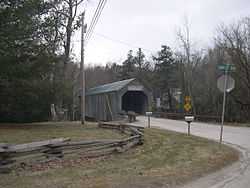
The north approach to the Kingsley bridge. The Rutland Airport landing strip is on the hill just to the right of this photo | |
| Nearest city | Clarendon, Vermont |
|---|---|
| Coordinates | 43°31′24.74″N 72°56′29.85″W / 43.5235389°N 72.9416250°WCoordinates: 43°31′24.74″N 72°56′29.85″W / 43.5235389°N 72.9416250°W |
| Built | 1836 |
| Architect | Horton,Timothy K. |
| Architectural style | Other |
| Governing body | Local |
| NRHP Reference # | 74000257 [1] |
| Added to NRHP | February 12, 1974 |
The Kingsley Covered Bridge (also called the Mill River Bridge) is a wooden covered bridge in Clarendon, Vermont. Built in 1836 by Timothy K. Horton, the bridge is a Town lattice style with a 120-foot (37 m) span across the Mill River. The bridge is listed on the National Register of Historic Places.
It is located west of Vermont Route 103 and just under the landing strip for the Rutland Airport on East Street Extension off Gorge Road, a paved road that turns to dirt after passing the bridge. It is a single lane bridge and is right next to the Kingsley Grist Mill and Mill Houses, all beautifully restored with informational plaques. The bridge is restricted to handling 3 tons and has an eleven-foot ceiling.
See also
- National Register of Historic Places listings in Rutland County, Vermont
- List of Vermont covered bridges
- List of bridges on the National Register of Historic Places in Vermont
References
- ↑ "National Register Information System". National Register of Historic Places. National Park Service. 2007-01-23.
| ||||||||||||||||||||||||||