Kingsdon, Somerset
| Kingsdon | |
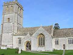 All Saints Church |
|
 Kingsdon |
|
| Population | 303 [1] |
|---|---|
| OS grid reference | ST515265 |
| District | South Somerset |
| Shire county | Somerset |
| Region | South West |
| Country | England |
| Sovereign state | United Kingdom |
| Post town | Somerton |
| Postcode district | TA11 |
| Dialling code | 01935 |
| Police | Avon and Somerset |
| Fire | Devon and Somerset |
| Ambulance | South Western |
| EU Parliament | South West England |
| UK Parliament | Somerton and Frome |
Coordinates: 51°02′09″N 2°41′35″W / 51.0358°N 2.6930°W
Kingsdon is a village and parish in the South Somerset district of Somerset, England, situated 3 miles (4.8 km) south east of Somerton. The village has a population of 303.[1]
History
The village is situated near the Fosse Way Roman road and two Roman villas were excavated in the village in the 19th century, but nothing remains of them today.[2]
The villages name is derived from Kingsdon Hill which is in the north west of the parish and reflects its history as part of the royal estate of Somerton at the time of the Norman Conquest. The manor was granted to the Gouvis family by 1194, and in 1528, bought by Thomas Arundell of Wardour Castle, whose descendants held it until it was sold to Aaron Moody in 1801.[2]

On 4 March 2010 the thatched roof of the Kingsdon Inn, the village pub, caught fire and the roof was destroyed.[3][4] £250,000 was subsequently[5] spent repairing the building which was built in the early 19th century.[6]
Governance
The parish council has responsibility for local issues, including setting an annual precept (local rate) to cover the council’s operating costs and producing annual accounts for public scrutiny. The parish council evaluates local planning applications and works with the local police, district council officers, and neighbourhood watch groups on matters of crime, security, and traffic. The parish council's role also includes initiating projects for the maintenance and repair of parish facilities, as well as consulting with the district council on the maintenance, repair, and improvement of highways, drainage, footpaths, public transport, and street cleaning. Conservation matters (including trees and listed buildings) and environmental issues are also the responsibility of the council.
The village falls within the Non-metropolitan district of South Somerset, which was formed on 1 April 1974 under the Local Government Act 1972, having previously been part of Langport Rural District.[7] The district council is responsible for local planning and building control, local roads, council housing, environmental health, markets and fairs, refuse collection and recycling, cemeteries and crematoria, leisure services, parks, and tourism.
Somerset County Council is responsible for running the largest and most expensive local services such as education, social services, libraries, main roads, public transport, policing and fire services, trading standards, waste disposal and strategic planning.
It is also part of the Somerton and Frome county constituency represented in the House of Commons of the Parliament of the United Kingdom. It elects one Member of Parliament (MP) by the first past the post system of election, and part of the South West England constituency of the European Parliament which elects seven MEPs using the d'Hondt method of party-list proportional representation.
Geography
To the east of the village lies the River Cary and Lytes Cary a manor house with associated chapel and gardens. The property, owned by the National Trust, has parts dating to the 14th century, with other sections dating to the 15th, 16th, 18th, and 20th centuries. "Yet all parts blend to perfection with one another and with the gentle sunny landscape that surrounds them," comments Nikolaus Pevsner.[8] The House is listed as Grade I by English Heritage.[9]
South of the village is the A372 road which runs to Bridgwater from the Podimore roundabout on the A303.
Education
There was a small Church of England Primary School, founded 1872,[10] with about 10 pupils aged 4–11 years. It closed in August 2011 due to pupil numbers.[11]
The village was, up until the end of the summer term 2008, home to Kingsdon Manor School, which served Bristol and other local areas as a residential Special School, for up to 40 boys aged 10–16 years with emotional or behavioural difficulties. It was housed in a large manor house built in 1830.[12]
Religious sites
The ancient church, dedicated to All Saints, has a four-stage tower which was built in the 15th century replacing a previous one over the north transept.[13] It has five bells and a clock; the parish is one of five in the benefice of 'Somerton with Compton Dundon, The Charltons and Kingsdon'.
References
- ↑ 1.0 1.1 "Statistics for Wards, LSOAs and Parishes — SUMMARY Profiles" (Excel). Somerset Intelligence. Retrieved 4 January 2014.
- ↑ 2.0 2.1 Bush, Robin (1994). Somerset: The complete guide. Wimborne: The Dovecote Press Ltd. pp. 124–125. ISBN 1-874336-26-1.
- ↑ "Heroes of pub blaze". This si Dorset. Retrieved 25 July 2011.
- ↑ "Firefighters battle village pub blaze". This is the West Country. Retrieved 25 July 2011.
- ↑ "300-year-old pub has been saved". This is Somerset. Retrieved 25 July 2011.
- ↑ "The Kingsdon Inn". Images of England. English Heritage. Retrieved 25 July 2011.
- ↑ "Langport RD". A vision of Britain Through Time. University of Portsmouth. Retrieved 4 January 2014.
- ↑ Pevsner, Nikolaus (1958). The Buildings of England, South and West Somerset. Penguin Books; Reprinted by Yale University Press, 2003,. pp. 228–229.
- ↑ "Lytes Cary". Images of England. English Heritage. Retrieved 2009-04-28.
- ↑ "Kingsdon C of E Primary School". Images of England. Retrieved 2009-01-21.
- ↑ "Kingsdon Church of England Primary School". Kingsdon Church of England Primary School. Retrieved 2010-10-02.
- ↑ "Kingsdon Manor School". Images of England. Retrieved 2009-01-21.
- ↑ "All Saints Church, Kingsdon". Images of England. Retrieved 2008-03-08.
External links
![]() Media related to Kingsdon, Somerset at Wikimedia Commons
Media related to Kingsdon, Somerset at Wikimedia Commons
