Kings Highway (BMT Brighton Line)
| Kings Highway | |||||||||||||||||||||||||||||||||||||
|---|---|---|---|---|---|---|---|---|---|---|---|---|---|---|---|---|---|---|---|---|---|---|---|---|---|---|---|---|---|---|---|---|---|---|---|---|---|
| New York City Subway rapid transit station | |||||||||||||||||||||||||||||||||||||
|
Platforms | |||||||||||||||||||||||||||||||||||||
| Station statistics | |||||||||||||||||||||||||||||||||||||
| Address |
Kings Highway & East 16th Street Brooklyn, NY 11229 | ||||||||||||||||||||||||||||||||||||
| Borough | Brooklyn | ||||||||||||||||||||||||||||||||||||
| Locale | Midwood, Sheepshead Bay | ||||||||||||||||||||||||||||||||||||
| Coordinates | 40°36′33″N 73°57′32″W / 40.609229°N 73.95884°WCoordinates: 40°36′33″N 73°57′32″W / 40.609229°N 73.95884°W | ||||||||||||||||||||||||||||||||||||
| Division | B (BMT) | ||||||||||||||||||||||||||||||||||||
| Line | BMT Brighton Line | ||||||||||||||||||||||||||||||||||||
| Services |
B Q | ||||||||||||||||||||||||||||||||||||
| Connection |
| ||||||||||||||||||||||||||||||||||||
| Structure | Embankment | ||||||||||||||||||||||||||||||||||||
| Platforms |
2 island platforms cross-platform interchange | ||||||||||||||||||||||||||||||||||||
| Tracks | 4 | ||||||||||||||||||||||||||||||||||||
| Other information | |||||||||||||||||||||||||||||||||||||
| Opened | original station: July 2, 1878 | ||||||||||||||||||||||||||||||||||||
| Rebuilt | current station: 1908 | ||||||||||||||||||||||||||||||||||||
| Accessible |
| ||||||||||||||||||||||||||||||||||||
| Traffic | |||||||||||||||||||||||||||||||||||||
| Passengers (2014) |
5,693,562[1] | ||||||||||||||||||||||||||||||||||||
| Rank | 76 out of 421 | ||||||||||||||||||||||||||||||||||||
| Station succession | |||||||||||||||||||||||||||||||||||||
| Next north |
Avenue M (local): Q Newkirk Plaza (express): B | ||||||||||||||||||||||||||||||||||||
| Next south |
Avenue U (local): Q Sheepshead Bay (express): B | ||||||||||||||||||||||||||||||||||||
|
| |||||||||||||||||||||||||||||||||||||
| Next |
Prospect Park: B | ||||||||||||||||||||||||||||||||||||
| Next |
Coney Island – Stillwell Avenue: Q | ||||||||||||||||||||||||||||||||||||
| |||||||||||||||||||||||||||||||||||||
Kings Highway is an express station on the BMT Brighton Line of the New York City Subway. Served by the Q train at all times and by the B on weekdays, it is located at Kings Highway between East 15th and East 16th Streets on the border of Midwood and Sheepshead Bay neighborhoods of Brooklyn.
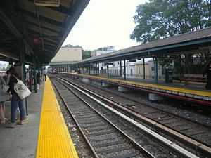
This station has four tracks and two island platforms. It has three fare control areas at street level—two to Kings Highway/East 16th Street and one to Quentin Road/East 16th Street. The two mezzanines at Kings Highway, located directly underneath the subway embankment, were constructed in the original BMT format, but fully renovated in the 1980s, during which two identical sets of porcelain enamel artwork (Kings Highway Hieroglyphs by Rhoda Andors) were installed, one set in each mezzanine.
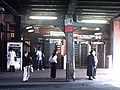
The entrance on the south side is normally the full-time entrance/exit, containing a turnstile bank, token booth, two staircases to each platform, and one exit-only turnstile from the Coney Island-bound platform. The one on the north is HEET access only, containing three turnstiles, a staircase to each platform and its MetroCard Vending Machines were installed on the sidewalk.
The part-time Quentin Road stationhouse, located to the east of the embankment, has a turnstile bank, part-time booth, and two staircases to each platform. It was built after the station's opening to accommodate growing passenger flow as evidenced by its newer-style tiling and signage. Platform extensions are clearly present at the north end of the station. It has a token booth, turnstile bank, and two staircases to each platform with the southbound side requiring a short walk.
South of Kings Highway are diamond crossover switches that allow trains to switch from the local tracks to the express ones, and vice versa. Before Brighton signal replacement during the 1990s, a switch tower was in operation about 150 feet south of the station, facing the southbound local track; this tower has been abandoned, and control of the switches has passed to a master tower at DeKalb Avenue. During the signal replacement, a new signal electrical tower was installed over the express tracks at the south end of the station.
This station underwent reconstruction from 2009-2011, which included installation of ADA-accessible elevators to the full-time fare control area and rebuilding of the platforms and station houses. A temporary platform was used to provide service that would normally stop at the closed platform.
Station layout
| 2F | Northbound local | ← |
| Island platform, doors will open on the left for local trains, right for express trains | ||
| Northbound express | ← | |
| Southbound express | → | |
| Island platform, doors will open on the left for local trains, right for express trains | ||
| Southbound local | → | |
| G | Street Level | Entrances/Exits |
| Station house | to entrances/exits, station agent, MetroCard vending machines | |
Gallery
-
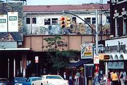
Kings Highway station, early 1980s
-
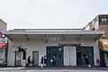
Quentin Road station house
-
Entrance at the north side of Kings Highway
References
- ↑ "Facts and Figures: Annual Subway Ridership". Metropolitan Transportation Authority. Retrieved 2015-04-30. Check date values in:
|accessdate=(help)
External links
![]() Media related to Kings Highway (BMT Brighton Line) at Wikimedia Commons
Media related to Kings Highway (BMT Brighton Line) at Wikimedia Commons
- nycsubway.org—BMT Brighton Line: Kings Highway
- Station Reporter — B Train
- Station Reporter — Q Train
- Artwork: "Kings Highway Hieroglyphics", Rhoda Yohai Andors (1987)
- The Official Subway and Rail Art Guide
- MTA's Arts For Transit — Kings Highway (BMT Brighton Line)
- The Subway Nut — Kings Highway Pictures
- Kings Highway entrance — south side from Google Maps Street View
- Kings Highway entrance — north side from Google Maps Street View
- Quentin Road entrance from Google Maps Street View
| ||||||||||