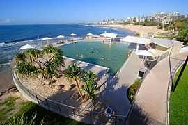
Kings Beach, Queensland
| Kings Beach Sunshine Coast, Queensland | |||||||||||||
|---|---|---|---|---|---|---|---|---|---|---|---|---|---|
 | |||||||||||||
| Coordinates | 26°48′04″S 153°08′28″E / 26.801°S 153.141°ECoordinates: 26°48′04″S 153°08′28″E / 26.801°S 153.141°E | ||||||||||||
| Population | 2,191 (2006 census)[1] | ||||||||||||
| • Density | 3,130/km2 (8,100/sq mi) | ||||||||||||
| Postcode(s) | 4551 | ||||||||||||
| Area | 0.7 km2 (0.3 sq mi) | ||||||||||||
| Location | 2 km (1 mi) E of Caloundra | ||||||||||||
| LGA(s) | Sunshine Coast Region | ||||||||||||
| County | Canning | ||||||||||||
| Parish | Bribie | ||||||||||||
| State electorate(s) | Caloundra | ||||||||||||
| Federal Division(s) | Fisher | ||||||||||||
| |||||||||||||
Kings Beach is a suburb of the Sunshine Coast, Queensland, Australia, located within the Caloundra urban centre directly east of Caloundra CBD.
History
Kings Beach was named after the King family, the first residents in the area. After living at Moffat Head in James Moffat’s home for a while, they moved to the Kings Beach area in 1893[2]
Within Kings Beach's boundaries is Wickham Head, a headland off which the hospital ship AHS Centaur is believed to have been sunk by Japanese submarines in 1943.[3]
Heritage listings
Kings Beach has a number of heritage-listed sites, including:
- Ormonde Terrace: Kings Beach Bathing Pavilion[4]
References
- ↑ Australian Bureau of Statistics (25 October 2007). "Kings Beach (Caloundra City) (State Suburb)". 2006 Census QuickStats. Retrieved 11 June 2011.
- ↑ Caloundra - Local Beach Guide 19 December 2006
- ↑ Dunn, Peter (2006). "Sinking of the hospital ship "Centaur" by Japanese submarine I-177 on 14 May 1943 off the Queensland coast east of Brisbane". Retrieved 21 June 2011.
- ↑ "Kings Beach Bathing Pavilion (entry 16276)". Queensland Heritage Register. Queensland Heritage Council. Retrieved 2013-07-14.