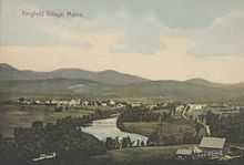
Kingfield, Maine
| Kingfield, Maine | |
|---|---|
| Town | |
|
Downtown in 2003 | |
 Kingfield, Maine Location within the state of Maine | |
| Coordinates: 44°58′26″N 70°10′3″W / 44.97389°N 70.16750°W | |
| Country | United States |
| State | Maine |
| County | Franklin |
| Incorporated | January 24, 1816 |
| Area[1] | |
| • Total | 43.28 sq mi (112.09 km2) |
| • Land | 43.12 sq mi (111.68 km2) |
| • Water | 0.16 sq mi (0.41 km2) |
| Elevation | 1,030 ft (314 m) |
| Population (2010)[2] | |
| • Total | 997 |
| • Estimate (2012[3]) | 988 |
| • Density | 23.1/sq mi (8.9/km2) |
| Time zone | Eastern (EST) (UTC-5) |
| • Summer (DST) | EDT (UTC-4) |
| ZIP code | 04947 |
| Area code(s) | 207 |
| FIPS code | 23-37025 |
| GNIS feature ID | 0582541 |
| Website | kingfield.me |

Kingfield is a town in Franklin County, Maine, United States. The population was 997 at the 2010 census. Kingfield is the principal gateway to Sugarloaf, a major ski resort, and is headquarters to Maine Huts and Trails.
History
The area was first known as township T3 R1 BKP WKR, or Plantation No. 3, Range 1 of Bingham's West Kennebec Purchase. It was first settled in 1806 by John W. Dutton, Nathaniel Kimball and their families, who built homes at the foot of Vose Mountain. In 1807, Plantation No. 3 was bought by William King, temporary resident and future governor of Maine, in partnership with three others.[4] On January 24, 1816, the township was incorporated as Kingfield, named after William King.[5]
Farms produced hay, potatoes, apples and pears. The confluence of the West Branch and Carrabassett rivers at the town's center provided 20 places for water power of industry. Kingfield businesses included sawmills, a shingle mill, gristmill, carding mill, rake factory, carriage factory and tannery.[6] In 1885, the town became headquarters to the Kingfield and Dead River Railroad, a narrow gauge line which would be merged with others to form the Sandy River and Rangeley Lakes Railroad. But with the Great Depression, industry in Kingfield began to decline, although the two mills of the Wing Spool & Bobbin Company remained in operation until the late 1950s. In the early 1950s, a local partnership organized Sugarloaf Mountain Ski Development, which transformed Sugarloaf Mountain into a ski resort. The Sugarloaf ski resort is an important part of the Kingfield economy.[7]
Geography
According to the United States Census Bureau, the town has a total area of 43.28 square miles (112.09 km2), of which, 43.12 square miles (111.68 km2) of it is land and 0.16 square miles (0.41 km2) is water.[1] Situated in the Carrabassett River valley, Kingfield is drained by the Carrabassett River.
Climate
This climatic region is typified by large seasonal temperature differences, with warm to hot (and often humid) summers and cold (sometimes severely cold) winters. According to the Köppen Climate Classification system, Kingfield has a humid continental climate, abbreviated "Dfb" on climate maps.[8]
Demographics
-

Bandstand and common in 1907
-

Old High School c. 1908, now the Stanley Museum
-
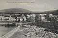
The dam in 1909
-

Suspension bridge c. 1910
-

thumb|Carrabassett River Valley and Mt Abram, overlooking the Town of Kingfield, Maine
2010 census
As of the census[2] of 2010, there were 997 people, 447 households, and 268 families residing in the town. The population density was 23.1 inhabitants per square mile (8.9/km2). There were 695 housing units at an average density of 16.1 per square mile (6.2/km2). The racial makeup of the town was 97.5% White, 0.4% African American, 0.1% Native American, 0.9% Asian, 0.2% Pacific Islander, and 0.9% from two or more races. Hispanic or Latino of any race were 0.4% of the population.
There were 447 households of which 25.1% had children under the age of 18 living with them, 47.9% were married couples living together, 6.9% had a female householder with no husband present, 5.1% had a male householder with no wife present, and 40.0% were non-families. 30.9% of all households were made up of individuals and 12.3% had someone living alone who was 65 years of age or older. The average household size was 2.23 and the average family size was 2.78.
The median age in the town was 46.3 years. 20.8% of residents were under the age of 18; 4.4% were between the ages of 18 and 24; 21.7% were from 25 to 44; 34.3% were from 45 to 64; and 18.6% were 65 years of age or older. The gender makeup of the town was 49.8% male and 50.2% female.
2000 census
As of the census[9] of 2000, there were 1,103 people, 454 households, and 304 families residing in the town. The population density was 25.4 people per square mile (9.8/km²). There were 659 housing units at an average density of 15.2 per square mile (5.9/km²). The racial makeup of the town was 98.37% White, 0.09% Native American, 0.18% Asian, 0.09% Pacific Islander, 0.27% from other races, and 1.00% from two or more races. Hispanic or Latino of any race were 0.18% of the population. 24.8% were of English, 18.0% American, 12.1% Irish, 8.0% French, 6.5% German, 5.3% French Canadian and 5.0% Finnish ancestry according to Census 2000.
There were 454 households out of which 32.6% had children under the age of 18 living with them, 51.5% were married couples living together, 11.5% had a female householder with no husband present, and 33.0% were non-families. 24.9% of all households were made up of individuals and 11.5% had someone living alone who was 65 years of age or older. The average household size was 2.43 and the average family size was 2.90.
In the town the population was spread out with 26.8% under the age of 18, 6.7% from 18 to 24, 29.5% from 25 to 44, 23.2% from 45 to 64, and 13.8% who were 65 years of age or older. The median age was 36 years. For every 100 females there were 95.2 males. For every 100 females age 18 and over, there were 85.9 males.
The median income for a household in the town was $29,250, and the median income for a family was $37,614. Males had a median income of $27,059 versus $20,547 for females. The per capita income for the town was $15,954. About 5.1% of families and 9.5% of the population were below the poverty line, including 9.3% of those under age 18 and 14.9% of those age 65 or over.
Sites of interest
- Kingfield Historical Society Museum
- Stanley Museum
- Herbert Grand Hotel
Education
Kingfield is part of Regional School Unit Number 58 and Maine School Administrative District Number 58.
Schools in the district include Kingfield Elementary School for students from Kindergarten to grade 8.[10]
Notable people
- Eugene Clark, Wisconsin State Senator
- William King, first governor of Maine
- Francis E. Stanley, inventor, businessman
- Freelan O. Stanley, inventor, businessman
- Malcolm Ravelli, professional bass fisherman
References
- ↑ 1.0 1.1 "US Gazetteer files 2010". United States Census Bureau. Retrieved 2012-12-16.
- ↑ 2.0 2.1 "American FactFinder". United States Census Bureau. Retrieved 2012-12-16.
- ↑ "Population Estimates". United States Census Bureau. Retrieved 2013-07-06.
- ↑ Maine League of Historical Societies and Museums (1970). Doris A. Isaacson, ed. Maine: A Guide 'Down East'. Rockland, Me: Courier-Gazette, Inc. p. 386.
- ↑ Coolidge, Austin J.; John B. Mansfield (1859). A History and Description of New England. Boston, Massachusetts. p. 182.
- ↑ Varney, George J. (1886), Gazetteer of the state of Maine. Kingfield, Boston: Russell
- ↑ "Kingfield History," Town of Kingfield, Maine
- ↑ Climate Summary for Kingfield, Maine
- ↑ "American FactFinder". United States Census Bureau. Retrieved 2008-01-31.
- ↑ "Schools". Town of Kingfield Maine. Retrieved 2012-11-06.
External links
| |||||||||||||||||||||||||||||

Coordinates: 44°57′33″N 70°09′14″W / 44.95917°N 70.15389°W