King River (Kimberley region, Western Australia)
| King River | |
|---|---|
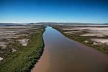 Looking towards the south east from above the mouth in Cambridge Gulf | |
| Origin | Durack Range |
| Mouth | Cambridge Gulf |
| Basin countries | Australia |
| Length | 132 kilometres (82 mi) |
| Source elevation | 387 metres (1,270 ft)[1] |
| Mouth elevation | sea level |
The King River is a river in the Kimberley of Western Australia.
The headwaters of the river rise between the Durack Range and the Saw Range. It flows southwards before turning north and continuing until it discharges into the West Arm of the Cambridge Gulf just South of Wyndham.
The river was named in 1884 during hydrographic surveys by Staff Commander James Coghlan after Captain Phillip Parker King who was the first European to chart the river mouth in 1818.[2]
The river flooded in 2005 following heavy rainfall when Cyclone Ingrid crossed the coast in the area. At Diggers Rest Station near Wyndham fences and livestock were swept away.[3]
The Indigenous Australian name for the river is Goolime and traditional owners of the areas around the river are the Arnga peoples.[4]
References
- ↑ "Bonzle Digital Atlas – Map of King River River". 2009. Retrieved 19 February 2009.
- ↑ Western Australian Land Information Authority. "History of river names". Retrieved 7 September 2011.
- ↑ Adrienne Francis (17 March 2005). "Tragedy strikes Kimberley station". Australian Broadcasting Corporation. Retrieved 4 May 2012.
- ↑ "AusAnthrop Australian Aboriginal tribal database". 2012. Retrieved 6 May 2012.
Coordinates: 15°29′37″S 128°4′12″E / 15.49361°S 128.07000°E