King's Pier

King's Pier is a 17th-century stone shipping quay, located on the Isle of Portland, Dorset, England; part of the Jurassic Coast. It is found at the boundary point of the land owned by Portland Port Ltd, on the east side of the island within the area of East Weares. To the north of the pier is Balaclava Bay, whilst further south along the coastline are the remains of Folly Pier and Folly Pier Waterworks, East Weares Rifle Range, the two Salt Pans, Little Beach and Durdle Pier respectively.[1] When active, King's Pier was one of the most important stone shipping pier sites.[2]
History

The pier was first recorded on a map in 1710, although historical documents reveal that King's Pier was completed in 1622, for the shipment of stone to Whitehall in London. Work originally started in 1619, and cost £700. British architect Inigo Jones chose Portland Stone for the rebuilding of the Banqueting House at Whitehall, London, in 1619, and from then on the island's stone became increasingly popular. The three-year contract between Jones and the island gave Portland the chance to build various roads, and also the piers along East Weares coastline. King's Pier was one of these, and became one of the main stone shipping places on the east side. With the establishment of the stone industry, quarry owners were given the right to erect piers with cranes for shipping stone from anywhere along the coastline.
The limestone quarries of East and Penn's Weares were the earliest to be quarried on the island, and were the location of Sir Christopher Wren's first workings of stone to rebuild London after the Great Fire of 1666. The quarries occupied a 200-300m wide strip along the east coast of the island between Church Ope Cove and King's Pier. At Penn's Weare the dressing process remains clear and evident from roughly dressed stone to finely square blocks, with dressing rough-out piles in situ. These remains continue northwards into East Weare, although 19th and 20th century development has caused significant damage.[3] The stone was shipped from the adjacent Durdle, Folly, and King's Piers, although only Durdle Pier remained well-preserved until early 2014 when storms destroyed the pier's standing wooden crane.[4] The stone for St. Paul's Cathedral came from the East and Penn's Weares quarries, and the majority of it was shipped from King's Pier.[5]
When stone was needed to rebuild St. Paul's Cathedral, a meeting in London was held on 20 January 1698, attended by the Archbishop of Canterbury, the Bishop of London, the Dean of St Pauls, Christopher Wren and others. This meeting agreed that a contract should be drawn up for Thomas Gilbert, the quarry agent and member of the London Masons Company. Within this contract, Gilbert was to create a substantial and effective pathway from the quarries to King's Pier, for the sum of £500. The contract also ensured that Gilbert would keep the pier in good condition, with sufficient repairs at a rate of £40 per annum.[6]
By the beginning of the 18th century King's Pier, Durdle Pier, as well as three piers situated around Church Ope Cove, had become well-established and favoured amongst Portland's piers. Other piers were located around the island's rugged coast; near Freshwater Bay, Underbank near Southwell, Folly Pier, as well as piers at West Weares, under West Cliff. However the latter proved to be briefly in use due to the unstable nature of the coastline, as well as a lack of roads. The best location for shipping stone was Castletown Pier, however it was situated far from the majority of the working quarries. The tracks from the quarries to the piers on the coastline were inadequate, and often impaired by heavy carts as well as landslides. If such a way was unable to be used, the neighbouring landowner was expected to allow quarry traffic to divert through their land, in return for Road Dues.[7]
In the Portland Year Book 1905, a chronology of the island, King's Pier was recorded as the location of an incident in the year of 1755. A cart loaded with 2 and a half tons of stone fell over the head of the King's Pier, and rolled down 100 feet without doing any other damage than breaking two of the horses ribs.[8]
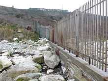
Once quarrying in the area was reduced, the quay fell out of use, and any cranes were removed. It is believed that the some of the remains of King's Pier were used in the foundations of the butt of a nearby, small rifle range further north along the coastline. This range was later demolished.[9] The remnants of the King's Pier quay ended up being used as a small breakwater with a fence on it to mark the beginning of the naval base. Portland Harbour was sold off by the Royal Navy in 1996 as a commercial port run by Portland Port Ltd and Portland Harbour Authority Limited.[10] The fencing to stop the public from entering the land on King's Pier continues to stand today.[11][12]
References
- ↑ Brandy Row - Shelagh Mazey - Google Books. Books.google.co.uk. Retrieved 2014-03-02.
- ↑ http://archaeologydataservice.ac.uk/archiveDS/archiveDownload?t=arch-804-1/dissemination/pdf/Isle_Of_Portland_Industrial_Archaeology_Survey_Report.pdf
- ↑ "Detailed Result: EAST AND PENNS WEARES QUARRIES". Pastscape. Retrieved 2014-03-02.
- ↑ "Detailed Result: DURDLE PIER". Pastscape. Retrieved 2014-03-02.
- ↑ Legg, Rodney (1999). Portland Encyclopaedia. Dorset Publishing Company. p. 65. ISBN 978-0948699566.
- ↑ Legg, Rodney (1999). Portland Encyclopaedia. Dorset Publishing Company. pp. 138, 139. ISBN 978-0948699566.
- ↑ Morris, Stuart (1985). Portland: An Illustrated History. Dovecote Press. p. 54. ISBN 978-0946159345.
- ↑ Paul Benyon (1903-12-01). "Portland Year Book". Freepages.genealogy.rootsweb.ancestry.com. Retrieved 2014-03-02.
- ↑ http://archaeologydataservice.ac.uk/archiveDS/archiveDownload?t=arch-804-1/dissemination/pdf/Isle_Of_Portland_Industrial_Archaeology_Survey_Report.pdf
- ↑ "Portland Harbour". Engineering Timelines. Retrieved 2014-03-02.
- ↑ "Kings Pier, Portland © Nigel Mykura :: Geograph Britain and Ireland". Geograph.org.uk. 2008-03-08. Retrieved 2014-03-02.
- ↑ "700730". Geoffkirby.co.uk. Retrieved 2014-03-02.
Coordinates: 50°33′33″N 2°25′17″W / 50.5591°N 2.4214°W
| ||||||||||||||||||||||||||||||||||||||||||||||||||||||||||||||||||