Kimsa Chata (Bolivia-Chile)
| Kimsa Chata | |
|---|---|
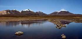 The Kimsa Chata volcanic group | |
| Elevation | 6,052 m (19,856 ft) |
| Location | |
| Location | Chile |
| Range | Andes |
| Coordinates | 18°23′S 69°03′W / 18.383°S 69.050°WCoordinates: 18°23′S 69°03′W / 18.383°S 69.050°W |
| Geology | |
| Type | Stratovolcano |
Kimsa Chata or Kimsachata (Aymara and Quechua kimsa three,[1] Pukina chata mountain,[2] "three mountains", hispanicized Quimsa Chata, Quimsachata) is a 8 km (5 mi)-long volcanic complex on a north-south alignment along the border between Bolivia and Chile, overseeing Chungara Lake. It contains three peaks, all stratovolcanoes.
The group is formed - from north to south - by Umurata (5,730 m (18,799 ft)), Acotango (6,052 m (19,856 ft)) and Capurata (5,990 m (19,652 ft)) (also known as Cerro Elena Capurata). The active volcano Guallatiri (Wallatiri) west of Capurata is not part of the group.
The Acotango is the central and highest of the three. It is in a fairly advanced stage of dissection, but a morphologically youthful lava flow on its northern flank suggests Holocene activity. Umarata, with a summit crater breached to the ESE, and Capurata, a complex of lava domes and associated pyroclastic-flow deposits, may also have been active during the Holocene.
See also
- List of volcanoes in Bolivia
- List of volcanoes in Chile
- Kuntur Ikiña
External links
Smithsonian Institution, volcanoes of Northern Chile, Bolivia and Argentina. http://www.volcano.si.edu/world/region.cfm?rnum=1505
Sources
- ↑ www.katari.org Aymara-Spanish dictionary: Kimsa (adj.) - Número Tres.
- ↑ Teofilo Laime Ajacopa, Lengua Pukina en Jesús de Machaca, referring to Alfredo Torero ("Reflexión acerca del pukina escrito por Alfredo Torero ... Pukina <Chata> - Castellano Cerro - Palabras relacionadas en aymara Qullu") (English: mountain). ... Existencia de palabras pukinas en Jesús de Machaca: Qullunaka (cerros): Kimsa Chata