Kimballton, Virginia
| Kimballton, Virginia | |
|---|---|
| Unincorporated community | |
 Kimballton, Virginia | |
| Coordinates: 37°21′58″N 80°40′38″W / 37.36611°N 80.67722°WCoordinates: 37°21′58″N 80°40′38″W / 37.36611°N 80.67722°W | |
| Country | United States |
| State | Virginia |
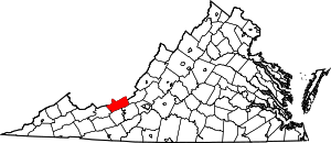
| County | Giles |
| Elevation | 1,686 ft (514 m) |
| Time zone | Eastern (EST) (UTC-5) |
| • Summer (DST) | EDT (UTC-4) |
| Area code(s) | 540 |
| GNIS feature ID | 1496965[1] |
Kimballton is an unincorporated community in Giles County, Virginia, United States. Kimballton is located on Stony Creek, 4.2 miles (6.8 km) northeast of Pearisburg. Virginia Tech's Kimballton Underground Research Facility, a low-background physics laboratory, is located in a mine in Kimballton.[2]
References
- ↑ "Kimballton". Geographic Names Information System. United States Geological Survey.
- ↑ "Low Background Physics at the Kimballton Underground Research Facility (KURF)". University of North Carolina Department of Physics and Astronomy. Retrieved August 21, 2012.
| |||||||||||||||||