Kilstett
| Kilstett | ||
|---|---|---|
| ||
 Kilstett | ||
|
Location within Alsace region  Kilstett | ||
| Coordinates: 48°40′35″N 7°51′24″E / 48.6764°N 7.8567°ECoordinates: 48°40′35″N 7°51′24″E / 48.6764°N 7.8567°E | ||
| Country | France | |
| Region | Alsace | |
| Department | Bas-Rhin | |
| Arrondissement | Strasbourg-Campagne | |
| Canton | Brumath | |
| Intercommunality | Gambsheim-Kilstett | |
| Government | ||
| • Mayor (2001–2008) | Gabriel Muller | |
| Area1 | 6.90 km2 (2.66 sq mi) | |
| Population (2006)2 | 2,280 | |
| • Density | 330/km2 (860/sq mi) | |
| INSEE/Postal code | 67237 / 67840 | |
| Elevation | 126–131 m (413–430 ft) | |
|
1 French Land Register data, which excludes lakes, ponds, glaciers > 1 km² (0.386 sq mi or 247 acres) and river estuaries. 2 Population without double counting: residents of multiple communes (e.g., students and military personnel) only counted once. | ||
.svg.png)
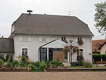
Town hall
Kilstett is a commune in the Bas-Rhin department in Alsace in north-eastern France.
Inhabitants are known as Kilstettois.
Geography
Kilstett is positioned about fifteen kilometrees (nine miles) to the north of Strasbourg.
It has its own stop on the little railway line that connects Strasbourg with the German frontier town of Lauterbourg, and is approximately three kilometres (two miles) to the east of Junction 50 on the Autoroute A35, which is the principal north-south highway in Alsace.
History
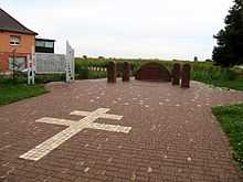
Battle of Kilstett memorial
In January 1945, a German counter-offensive intended to reconquer Strasbourg was stopped at the Battle of Kilstett.
See also
References
| Wikimedia Commons has media related to Kilstett. |