Kilmurry Ibrickane
| Kilmurry Ibrickane Cill Mhuire Uí Bhreacáin | |
|---|---|
| Civil parish | |
 Kilmurry Ibrickane Location in Ireland | |
| Coordinates: 52°47′59″N 9°27′16″W / 52.799722°N 9.454444°W | |
| Country | Ireland |
| Province | Munster |
| County | County Clare |
| Government | |
| • Dáil Éireann | Clare |
| Time zone | WET (UTC+0) |
| • Summer (DST) | IST (WEST) (UTC-1) |
Kilmurry Ibrickane (Irish: Cill Mhuire Uí Bhreacáin[1]) is the name of a civil parish in County Clare, Ireland,[2] and an ecclesiastical parish in the Roman Catholic Diocese of Killaloe. The parish contains the tiny settlement of Kilmurry which was the location of the church before the Cromwellian conquest of Ireland.[3] Main settlements in the parish are Mullagh, Coore and Quilty. The parish is also known for the GAA club, Kilmurry Ibrickane GAA.[4]
Catholic parish
History
It is unknown when the parish Kilmurry Ibrickane came into existence. For a long period is was ministered together with the parish of Kilfarboy (Milltown Malbay).[5] The "Register of Priests" in 1704 mentioned Fr. Teige and Fr. Francis Shannon as priests in respectively Kilfarboy and Kilmurry Ibrickane, but according to Ó Murchadha, there is little doubt that they in fact acted as priest and curate for both parishes.[6] Francis Shannon was officiating both in Kilfarboy and Kilmurry Ibrickane by 1715.[7]
In the 1830s, the population in the combined parishes had risen to about 20.000 people, so a split became necessary. The priest and his curate, the brothers Anthony and Patrick McGuane, started building two identical churches in Milltown Malbay and Mullagh, but the Night of the Big Wind prevented completion of the church in Mullagh. The planned tower and spire were never built. When Fr. Anthony McGuane died in 1839, his brother Fr. Patrick became the first parish priest of Kilfarboy. A cousin of them, Fr. E.B. (Edmund) Barry, became the first parish priest of Kilmurry Ibrickane.[6]
Fr. Thomas Moloney, then curate at Kilmurry Ibrickane, was a supporter of the Young Ireland movement. During the Great Famine he worked tirelessly to get the word out of the disaster happening in Ireland, through newspapers and political contacts.[8] Today the Catholic parish is known as Mullagh, after the principal settlement.[7]
Churches
Churches are:[9]
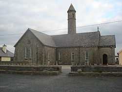
- St. Mary's Church, Mullagh. Built 1839.[6]
- The Most Holy Redeemer, Coore. Built 1865-1866.[10]
- Our Lady Star of the Sea, Quilty. Built 1909, in the aftermath of the rescue of the seamen from the French freighter Leon XIII.[11]
List of parish priests
Parish priests were:[12]
- Rev. Edmund Barry (1839-1860)
- Rev. Patrick Moran (1860-1875)
- Rev. James Cahir (1876-1914)
- Rev. John Glynn (1914-1930)
- Rev. Patrick Scanlon (1930-1932)
- Rev. Patrick J. O'Halloran (1932-1947)
- Rev. Peter Ryan (1948-1961)
- Rev. Jeremiah Cahir (1961-1966)
- Rev. Henry Kenny (1966-1969)
- Rev. John Greed (1969-1972)
- Rev. Thomas Murphy (1972-1980)
- Rev. Michael Green (1981-1986)
- Rev. Timothy Tuohy (1986-2001)
- Rev. Patrick Larkin (2002–2014)
Civil parish
The parish is part of the historic barony of Ibrickane. In 1837, it was co-extensive with the parish of the Established Church and of the Roman Catholic Church.[13]
Townlands
The parish is divided into 52 townlands:[14]
- Annagh
- Ballymackea Beg
- Ballymackea More
- Caherrush
- Carrowduff
- Carrowlagan
- Carrownagry North
- Carrownagry South
- Cloghauninchy
- Cloghaunnatinny
- Cloonadrum
- Cloonlaheen East
- Cloonlaheen Middle
- Cloonlaheen West
- Coor East
- Coor West
- Craggaun
- Craggaknock East
- Craggaknock West
- Creevagh
- Derreen
- Doolough
- Doonogan
- Doonsallagh East
- Doonsallagh West
- Drummin
- Emlagh
- Finnor Beg
- Finnor More
- Kilclehaun
- Killernan
- Knockanalban
- Knocknahila Beg
- Knocknahila More North
- Knocknahila More South
- Knockloskeraun
- Lissyneillan
- Molosky
- Moyglass Beg
- Moyglass More
- Mutton Island
- Quilty East
- Quilty West
- Rineroe
- Seafield
- Shanavogh East
- Shanavogh West
- Shandrum
- Treanmanagh
- Tromracastle
- Tromra East
- Tromra West
Note
- ↑ Cill Mhuire Uí Bhreacáin, Placenames Database of Ireland.
- ↑ "Clare Civil Parishes". Clare County Library. Retrieved 3 March 2014.
- ↑ Kilmurry Ibrickane Church
- ↑ Club Executive for 2012 Adult Management Teams
- ↑ Parliamentary Gazeteer of Ireland 1845
- ↑ 6.0 6.1 6.2 Ó Murchadha 2008, p. 180.
- ↑ 7.0 7.1 Mullagh (Kilmurry-Ibrickane), Killaloe Diocese.
- ↑ Ó Murchadha 2008, p. 182.
- ↑ Mullagh (Kilmurry-Ibrickane), Churches, Killaloe Diocese.
- ↑ Ó Murchadha 2008, p. 181.
- ↑ Ó Murchadha 2008, p. 181-182.
- ↑ Ó Murchadha 2008, p. 75.
- ↑ Lewis, Samuel (1995). County Clare, A History and Topography. Ennis: CLASP Press. ISBN 1-900545-00-4. p. 37
- ↑ "Kilmurry Ibrickane townlands". Clare County Library. Retrieved 3 March 2014.
Sources
- "Cill Mhuire Uí Bhreacáin". Placenames Database of Ireland. Retrieved 2014-04-08.
- "Mullagh (Kilmurry-Ibrickane)". Killaloe Diocese. Retrieved 2014-04-08.
- "Mullagh (Kilmurry-Ibrickane), Churches". Killaloe Diocese. Retrieved 2014-04-08.
- Ó Murchadha, Ciarán (2008). The Diocese of Killaloe : An illustrated History. Booklink Ireland. p. 180.
External links
| ||||||||||||||||||
| ||||||||||||||||||||||||||||||||||||||||||||||||||||||
Coordinates: 52°47′55.06″N 9°25′58.84″W / 52.7986278°N 9.4330111°W