Killbuck Creek
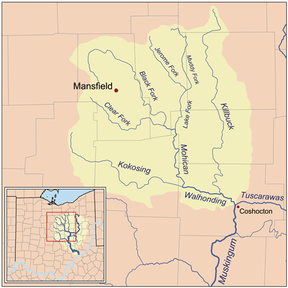
Killbuck Creek is a tributary of the Walhonding River, [1] 81.7 mi (131.5 km) long,[2] in north-central Ohio in the United States. Via the Walhonding, Muskingum and Ohio Rivers, it is part of the watershed of the Mississippi River. It drains an area of 613 mi² (1588 km²).[2]
Killbuck Creek rises in northern Wayne County and initially flows in a counter-clockwise loop northward into southern Medina County and past the town of Burbank before turning to a southward course through Wayne, Holmes and Coshocton Counties to its mouth at the Walhonding River,[3] 5 mi (8 km) west of the city of Coshocton.[1] Along its course it flows to the west of the city of Wooster and passes the towns of Holmesville, Millersburg and Killbuck.[3]
Name
Killbuck Creek and the town of Killbuck are named for the Shawnee war chief Bemino (fl. 1710s–1780s) — known as John Killbuck, Sr, to the whites. According to the Geographic Names Information System, the stream has been known and spelled variously over the years:[4]
- Kilbuck Creek
- Killbuck Run
- Killbucks Creek
- Kilbuck River
- Kill-Buck River
The United States Board on Geographic Names settled on "Killbuck Creek" as the stream's name in 1963.
See also
References
- ↑ 1.0 1.1 Columbia Gazetteer of North America entry
- ↑ 2.0 2.1 Ohio Department of Natural Resources. A Guide to Ohio Streams. Chapter 10: Major Ohio Watersheds (pdf)
- ↑ 3.0 3.1
- DeLorme (1991). Ohio Atlas & Gazetteer. Yarmouth, Maine: DeLorme. ISBN 0-89933-233-1
- ↑ U.S. Geological Survey Geographic Names Information System: Killbuck Creek