Kick 'em Jenny
| Kick 'em Jenny | |
|---|---|
|
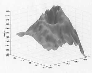
Location map of submarine volcano Kick-'em-Jenny | |
 | |
| Summit depth | −180 m (−591 ft)[1] |
| Height | 1,300 m (4,265 ft)[1] |
| Location | |
| Location | Caribbean Sea, north of Grenada |
| Coordinates | 12°18′N 61°38′W / 12.30°N 61.64°W[1] |
| Geology | |
| Type | Submarine volcano (seamount) |
| Last eruption | December 2001[1] |

Kick 'em Jenny (also: Kick-'em-Jenny or Mt. Kick-'Em-Jenny) is an active submarine volcano or seamount on the Caribbean Sea floor, located 8 km (5 mi) north of the island of Grenada and about 8 km (5 mi) west of Ronde Island in the Grenadines. Kick-'em-Jenny rises 1,300 m (4,265 ft) above the sea floor on the steep inner western slope of the Lesser Antilles ridge. The South American tectonic plate is subducting the Caribbean tectonic plate to the east of this ridge and under the Lesser Antilles island arc.[2]
Activity
The first record of the volcano was in 1939,[3] although it must have erupted many times before that date. On 23–24 July 1939 an eruption broke the sea surface, sending a cloud of steam and debris 275 m (902 ft) into the air and generating a series of tsunamis around two metres high when they reached the coastlines of northern Grenada and the southern Grenadines. A small tsunami also reached the West coast of nearby Barbados, where 'a sea-wave' suddenly washed over a coastal road.
The volcano has erupted on at least twelve occasions between 1939 and 2001 (the last being on December 4, 2001), although none of the eruptions have been as large as the 1939 one, and most were only detected by seismographs. The larger eruptions have also been heard underwater or on land close to the volcano as a deep rumbling sound.[1]
A submersible survey in 2003 detected a crater with active fumaroles releasing cold and hot gas bubbles. The summit was measured to be 180 m (591 ft) below the sea surface and is thought to have remained constant since the 1960s.[1] Samples of fresh olivine basalt were collected. An arc shaped collapse structure appears on the west flank and was the apparent source of a submarine debris avalanche extending 15 km down the ridge slope to the west toward the Grenada Basin.[4]
Etymology
The volcano was unknown before 1939, although "Kick 'em Jenny" appeared on earlier maps as either the name of a small island now called Diamond Rock (or Île Diamante), or the name of the strait between Grenada and Ronde Island (or Île de Ronde). The name itself may be a reference to the waters sometimes being extremely rough.[1]
See also
References
- ↑ 1.0 1.1 1.2 1.3 1.4 1.5 1.6 Topinka, Lyn (2001-12-12). "DESCRIPTION: Kick 'Em Jenny Volcano, West Indies". United States Geological Service. Retrieved 2009-10-16.
- ↑ "Kick em' Jenny-Home". The University of West Indies-Seismic Center. Retrieved 2009-10-16.
- ↑ Lopes, Rosaly M. C. (2005), The volcano adventure guide, Cambridge University Press, Illustrated ed. p. 11. ISBN 0-521-55453-5
- ↑ Mattox, Steve (April 5, 2002). "Kick-'em-Jenny, West Indies". The University of Oregon. Retrieved 2009-10-16.