Khura Buri District
| Khura Buri คุระบุรี | |
|---|---|
| Amphoe | |
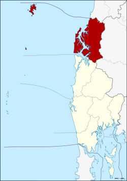 Amphoe location in Phang Nga Province | |
| Coordinates: 9°11′38″N 98°24′54″E / 9.19389°N 98.41500°ECoordinates: 9°11′38″N 98°24′54″E / 9.19389°N 98.41500°E | |
| Country |
|
| Province | Phang Nga |
| Seat | Khura |
| Area | |
| • Total | 797.1 km2 (307.8 sq mi) |
| Population (2005) | |
| • Total | 23,308 |
| • Density | 29.2/km2 (76/sq mi) |
| Time zone | THA (UTC+7) |
| Postal code | 82150 |
| Geocode | 8206 |
Khura Buri (Thai: คุระบุรี) is a district (amphoe) in the province Phang Nga in the south of Thailand.
Geography
The district is located at the coast to the Andaman Sea as the northernmost district of Phang Nga Province. Neighboring districts are (from the north clockwise) Suk Samran (Ranong Province), Ban Ta Khun and Phanom of Surat Thani Province, and Takua Pa to the south.
To the south of the district is the Si Phang-nga National Park. The Similan Islands, the Surin Islands, and the Ra and Phra Thong Islands directly off the coast are further national parks within the district.
History
Originally, the district was the capital district of the province Takua Pa, thus named Amphoe Mueang Takua Pa. In 1913 the province hall was moved to within the present-day town of Takua Pa, so the district was renamed to Ko Kho Khao after its central tambon.[1] The following year the district was renamed to Pak Nam,[2] which was undone in 1917.[3] The district was then reduced to a minor district (King Amphoe) on September 1, 1938.[4] After the district office was moved to tambon Khura in 1964,[5] the district was renamed to Khura Buri in 1968.[6] On August 8, 1975 the district was elevated to full district (amphoe) status.[7]
The tambon Ko Kho Khao, originally the center of the district, was transferred to Takua Pa district on December 28, 1988.[8]
Administration
The district Khura Buri is subdivided into 4 subdistricts (tambon), which are further subdivided into 33 villages (muban). Khuraburi itself has township (thesaban tambon) status and covers parts of the tambon Khura and Mae Nang Khao. Each of the tambon is administrated by a Tambon administrative organization (TAO).
|
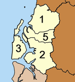 |
The missing number 4 was assigned to tambon Ko Kho Khao, which was transferred to Takua Pa district.
References
- ↑ แจ้งความกระทรวงมหาดไทย เรื่อง เปลี่ยนนามอำเภอเมือง ๆ เก่า เมืองตะกั่วป่า เป็น อำเภอเกาะคอเฃา. Royal Gazette (in Thai) 30 (0 ง): 576. September 28, 1913.
- ↑ แจ้งความกระทรวงมหาดไทย เรื่อง เปลี่ยนชื่ออำเภอเกาะคอเขาเป็นอำเภอปากน้ำ. Royal Gazette (in Thai) 30 (0 ง): 2574. February 1, 1914.
- ↑ ประกาศกระทรวงมหาดไทย เรื่อง เปลี่ยนชื่ออำเภอ. Royal Gazette (in Thai) 34 (0 ก): 40–68. April 1, 1917.
- ↑ ประกาศสำนักนายกรัฐมนตรี เรื่อง ยุบรวมอำเภอ และยุบอำเภอลงเป็นกิ่งอำเภอ. Royal Gazette (in Thai) 55 (0 ง): 1840. August 29, 1938.
- ↑ ประกาศกระทรวงมหาดไทย เรื่อง การย้ายที่ว่าการกิ่งอำเภอเกาะคอเขา. Royal Gazette (in Thai) 81 (116 ง): 2935. 1964-12-08.
- ↑ พระราชกฤษฎีกาเปลี่ยนชื่อกิ่งอำเภอและตำบลบางแห่ง พ.ศ. ๒๕๑๑. Royal Gazette (in Thai) 85 (98 ก): 774–777. October 29, 1968.
- ↑ พระราชกฤษฎีกาตั้งอำเภอแวงน้อย อำเภอป่าแดด อำเภอเรณูนคร อำเภอคูเมือง อำเภอคุระบุรี อำเภอแม่ลาน้อย อำเภอเสริมงาม อำเภอไพรบึง และอำเภอหนองโดน พ.ศ. ๒๕๑๘. Royal Gazette (in Thai) 92 (166 ก special issue): 1–4. August 21, 1975.
- ↑ พระราชกฤษฎีกาเปลี่ยนแปลงเขตอำเภอคุระบุรีกับอำเภอตะกั่วป่า จังหวัดพังงา พ.ศ. ๒๕๓๑. Royal Gazette (in Thai) 105 (239 ก special issue): 13–15. December 30, 1988.
External links
| ||||||