Khlong Thom District
| Khlong Thom คลองท่อม | |
|---|---|
| Amphoe | |
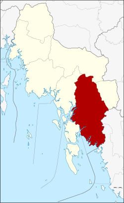 Amphoe location in Krabi Province | |
| Coordinates: 7°57′12″N 99°8′42″E / 7.95333°N 99.14500°ECoordinates: 7°57′12″N 99°8′42″E / 7.95333°N 99.14500°E | |
| Country |
|
| Province | Krabi |
| Seat | Khlong Thom |
| Area | |
| • Total | 1,042.531 km2 (402.523 sq mi) |
| Population (2008) | |
| • Total | 70,337 |
| • Density | 67.5/km2 (175/sq mi) |
| Time zone | THA (UTC+7) |
| Postal code | 81120 |
| Geocode | 8104 |
Khlong Thom (Thai: คลองท่อม) is a district (amphoe) in Krabi Province, Thailand.
Geography
Neighboring districts are (from the west clockwise) Ko Lanta, Nuea Khlong, Khao Phanom and Lam Thap of Krabi Province, and Wang Wiset and Sikao of Trang Province. To the southwest is the Andaman Sea.
History
In 1917 the district was renamed from Khlong Phon (คลองพล) to Khlong Thom.[1]
Administration
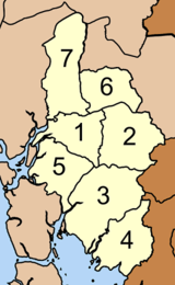
The district is subdivided into 7 subdistricts (tambon), which are further subdivided into 67 villages (muban). There are two subdistrict municipalities (thesaban tambon) - Khlong Thom Tai and Khlong Phon, each covering parts of the same-named tambon. Each tambon has a Tambon administrative organization (TAO), responsible for the area not belonging to any of the municipalities.
| No. | Name | Thai | Villages | Inh.[2] |
|---|---|---|---|---|
| 1. | Khlong Thom Tai | คลองท่อมใต้ | 9 | 11,686 |
| 2. | Khlong Thom Nuea | คลองท่อมเหนือ | 8 | 5,877 |
| 3. | Khlong Phon | คลองพน | 14 | 18,384 |
| 4. | Sai Khao | ทรายขาว | 7 | 10,092 |
| 5. | Huai Nam Khao | ห้วยน้ำขาว | 10 | 8,636 |
| 6. | Phru Din Na | พรุดินนา | 10 | 9,833 |
| 7. | Phela | เพหลา | 9 | 5,829 |
References
- ↑ ประกาศกระทรวงมหาดไทย เรื่อง เปลี่ยนชื่ออำเภอ. Royal Gazette (in Thai) 34 (0 ก): 40–68. 1917-04-29.
- ↑ "Population statistics 2008". Department of Provincial Administration.
External links
- amphoe.com (Thai)