Khao Sam Roi Yot National Park
| Khao Sam Roi Yot National Park | |
|---|---|
|
IUCN category II (national park) | |
|
Harbor of Bang Pu | |
 Map of Thailand | |
| Location | Prachuap Khiri Khan Province, Thailand |
| Nearest city | Pranburi |
| Coordinates | 12°10′57″N 99°56′54″E / 12.18250°N 99.94833°ECoordinates: 12°10′57″N 99°56′54″E / 12.18250°N 99.94833°E |
| Area | 98,08 km² |
| Established | 1966 |

Khao Sam Roi Yot (Thai: เขาสามร้อยยอด) is a marine national park in Sam Roi Yot district, Prachuap Khiri Khan Province, Thailand. It covers 98.08 km², of which 20.88 km² are marine areas. The park was established in 1966, and was the first coastal national park of Thailand.
Rare animals in the park include the Mainland Serow (Nemorhaedus sumatraensis), Dusky Langurs (Trachypithecus obscurus), as well as many bird species. In the ocean occasionally Irrawaddy Dolphins (Orcaella brevirostris) show up.
Geography
The name Khao Sam Roi Yot means Mountains with 300 peaks, which describes the landscape of the park quite well. The limestone hills are a subrange of the Tenasserim Hills that rises directly at the shore of the Gulf of Thailand, with the highest elevation Khao Krachom 605m above sea level. Between the hills are freshwater marshes. However several of these marshes were converted into shrimp farms, as only 36 km² of the total 69 km² of marshes are part of the national park. 18 km² of these marshes are scheduled to be declared a Ramsar site.
Two white sand beaches are located within the park namely Hat Laem Sala and Hat Sam Phraya. Hat Laem Sala is 17 km from the park's headquarters and can be reached from the village Ban Pu either by boat or by climbing up and down over a hill for nearly 30 minutes.
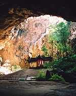
Phraya Nakhon Cave
The Phraya Nakhon Cave is located at Moo 2, Ban Khaodang, Khaodang sub-district, Kui buri district, Prachuap Khiri Khan province in Thailand. This cave was discovered about 200 years ago by Chao Praya Nakhon Sri Thammarat while he was searching for a shelter during a storm. He explored the upper part of the mountain and found the cave so this cave is known as "Phraya Nakhon Cave”.
Phraya Nakhon Cave is managed by Khao Sam Roi Yot National Park. It is about 500 meters from Laem Sala beach and approximately 17 kilometers north from Khao Sam Roi Yot National Park. Tourists can go to the cave by renting a boat or by walking across Tian Mountain. After that, there is a climb up the mountain about 430 meters to reach the Phraya Nakhon cave. There is a well located at the footpath of the mountain known as Phraya Nakhon Well. It is made of baked clay bricks in a trapezoid shape. It was dug for drinking water in the past.
Phraya Nakhon cave is a large cave which has a big hole in the ceiling so light from the sun can come through into the cave. At the top of the hole, there is a stone bridge known as Death-Bridge. It is so called because many wild animals fell from the bridge. Below the cave is a jungle, where most of the trees are tall. There are a lot of beautiful stalactites which look like waterfalls. Many kings of Thailand in different reigns went to see this cave and left many things to show evidence of their visit. The outstanding feature of Phraya Nakhon Cave is Thpone, a historic site that made during King Rama 5’ reign (King Chulalongkorn). 10:30AM - 11:30AM is the best time to see the Thpone because the sun shines over the Thpone at that time and it is a very beautiful sight. Thpone has since become the symbol of Prachuap Khiri Khan Province.
History
The area of the Khao Sam Roi Yot was probably the site where King Mongkut convened with European guests on August 18, 1868 to observe a total solar eclipse. The king was very interested in astronomy and had calculated the date and location of the eclipse himself. However he contracted malaria during that event, and died shortly later.
Later kings also visited the area, especially the Phraya Nakhon cave. The cave consists of two caverns, illuminated by the collapsed roofs. For the visit of King Chulalongkorn in 1890 the Kuha Karuhas pavillon was built inside the cave. Later King Vajiravudh as well as the current king Bhumibol Adulyadej visited the cave.
The national park was created on June 28, 1966.[1] It was enlarged on April 1, 1982.[2]
Khao Sam Roi Yot legends
According to Thai folklore, the giant Mong Li and his wife, who lived on the west coast of the Gulf of Thailand, had promised their daughter independently to Chao Lai and the emperor of China. When the daughter became old enough to marry, both future husbands arrived on the same date. Mong Li then cut his daughter into two halves. Chao Lai turned himself into a hill, while the traditional fruit basket to be presented to a Buddhist monk was turned into the Khao Sam Roi Yot mountains.
Islands
The island of Ko Kho Ram on the other side of the gulf was the elephant and the ox cart with the wedding presents.[3] Nom Sao Island is the daughter's breasts. Ao Sam Roi Yot, Kho Ram Island and Nom Sao Island's silhouette, seen from certain angles, look like a person resting in the middle of the sea. There is a goddess shrine on Nom Sao Island that is a popular attraction.[4]
Other island in the same area are Ko Sattakut, Ko Rawang and Ko Rawing.[5]
See also
Further reading
- Denis Gray, Collin Piprell, Mark Graham: National Parks of Thailand. Communications Resources Ltd., Bangkok 1991, ISBN 974-88670-9-9
References
- ↑ พระราชกฤษฎีกากำหนดบริเวณที่ดินป่าเขาสามร้อยยอด ในท้องที่ตำบลสามร้อยยอด ตำบลศิลาลอย อำเภอปราณบุรี และตำบลสามกระทาย ตำบลดอนยายหนู ตำบลเขาแดง อำเภอกุยบุรี จังหวัดประจวบคีรีขันธ์ ให้เป็นอุทยานแห่งชาติ พ.ศ. ๒๕๐๙ (PDF). Royal Gazette (in Thai) 83 (53 ก): 420–423. June 28, 1966.
- ↑ พระราชกฤษฎีกาขยายเขตอุทยานแห่งชาติป่าเขาสามร้อยยอด ในท้องที่ตำบลสามร้อยยอด ตำบลศิลาลอย ตำบลไร่เก่า อำเภอปราณบุรี และตำบลสามกระทาย ตำบลดอนยายหนู ตำบลเขาแดง อำเภอกุยบุรี จังหวัดประจวบคีรีขันธ์ พ.ศ. ๒๕๒๕ (PDF). Royal Gazette (in Thai) 99 (46 ก special): 5–8. April 1, 1982.
- ↑ Ko Kho Ram - Mapcarta
- ↑ Khao Sam Roi Yot National Park - Activities
- ↑ Ko Rawing
External links
| Wikimedia Commons has media related to Khao Sam Roi Yot National Park. |
- National Park, Wildlife and Plant Conservation Department
- ASEAN Regional Centre for Biodiversity Conservation
- Bangkok Post article in the land use controversies
- thaibirding.com on Khao Sam Roi Yot national park
- Prachuap Khiri Khan: beaches and attractions
- Travel to Phraya Nakhon Cave (in Thai)
- Phraya Nakhon Cave – Prachuaptown (in Thai)
- The park King Chulalongkorn visited (in Thai)