Khangabok
| Khangabok | |
|---|---|
| Village | |
 Khangabok Location in Manipur, India | |
| Coordinates: 24°36′31″N 94°00′10″E / 24.6084817°N 94.0028737°ECoordinates: 24°36′31″N 94°00′10″E / 24.6084817°N 94.0028737°E | |
| Country |
|
| State | Manipur |
| Area | |
| • Total | 20.47 km2 (7.90 sq mi) |
| Elevation | 781 m (2,562 ft) |
| Population (2011) | |
| • Total | 14,667 |
| • Density | 720/km2 (1,900/sq mi) |
| Demonym | Khangabok Macha |
| Languages | |
| • Official | Meiteilon (Manipuri) |
| Time zone | IST (UTC+5:30) |
| PIN | 795138 |
| Telephone code | 91-3848 |
| Vehicle registration | MN04 |
| Sex ratio | 98.5 ♂/♀ |
Khangabok is a village located about 25 km south of Imphal, in the state of Manipur, India. Its jurisdiction falls under the Thoubal District Division. Khangabok is one of the largest villages in Manipur in terms of area and population.
The Meiteis are the only ethnic group in the village. The language spoken is Meiteilon (also known as Manipuri), which is recognized as one of India's national languages in 1992.
History
There is a myth regarding the naming of "Khangabok". Years ago, Khangabok was covered under thick forest of Khangra, a type of tree. As population grew, the Khangra tree were cleared to make way for new settlements. These fallen tree were popular for firewood and building material. Gradually people started calling the place as Khangrapokpi (place where Khangra grows). Later the word was shortened to Khangrabok, and to Khangabok. The name is sometimes misspelt as Khangbok, instead of Khangabok.
The Department of Archaeology, Government of Manipur, carried out excavation at Khangabok[1] with a view of ascertaining the cultural sequence and studying the ethno-archaeology of the site in the campus of Khangabok Maisnam Leikai Boys' Primary School. Many goods comprising beads, bronze rings and plates, bones, potsherds were recovered from burial graves. The excavation revealed only the secondary pot burials with fragments of skull and bone with one to three pots from each burial. In addition, pot of medium size covered with ring-footed bowls were also unearthed. At least four to six thin bronze plates were found with each burial, perhaps used in ceremonial offerings.
Population
As per size of electorate as on January 2011,[2] the total population of Khangabok (Village Code=00141500) is 14667. Male comprises 50.37% (7388) of the total population.
Most of the people practice dual religion, namely Sanamahism and Hinduism. There are also Christians and Baha'i Faith followers in the village. Lainingthou Ikop Ningthou is the Umanglai (village deity) of Khangabok for which the Lai Haraoba (pleasing of the village deity) is celebrated annually with traditional fervour in the month of Kalen (equivalent to May in English calendar).
Geography, Vegetation and Climate
Total area of Khangabok is 20.47 square kilometer,[3] making it as the largest village in Thoubal District. Khangabok lies between 24-55 North latitudes and 94-98 East longitudes. Khangabok, because of its large area, is divided into three zones:
Part 1: (Awang Leikai, Sorok Wangma, Shanirou, Khullakpam Leikai and Maning Leikai),
Part 2: (Moirang Palli, Mayai Leikai, Loishang, and Maisnam Leikai) and
Part 3: (Makha Leikai, Khunou, Cherapur, Laipat, Tangkha Leikai and Lamlong).
Khangabok is bounded in the north-west by Athokpam village, in the north-east by Charangpat village, in the east by Hayel-Labuk village, in the south by Wanjing village and Tentha village, and in the west by Ikop Pat (Lake).
Khangabok represents the features of flat plain topography. The soil is of the type alluvium and contains small rock fragments, sand and sandy clay. The vegetation consists of a large variety of plants ranging from short and tall grasses, reeds and bamboos to trees of various species. Arundo Donax (yengtou), Leihao, Bamboo, Cane, Eucalyptus etc. are important forest resources growing in plenty.
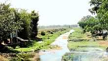
There are four rivers that run through Khangabok and they are named as Karak River, Arong River, Shagonkong (also known as Hogaibi) River and Nongdambi River. The Ikop Pat, which is situated in the western side of Khangabok, is one of the largest lakes in Manipur.
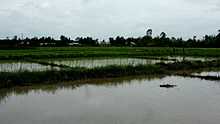
The climate of Khangabok is largely influenced by the topography of the hilly region which defines the geography of Manipur. Like other places in Manipur, the village is blessed with a generally amiable climate though the winters can be a little chilly. The maximum temperature recorded in the summer months is around 32 degree Celsius. In winter the mercury often falls near to zero degree Celsius. The coldest month is in January and July experiences the maximum summer temperature. The weather remains bright and sunny without the scorch of the sun during the period from October to March. The village is also drenched in rains from the months of May and continues till the middle of October. The downpour ranges from light drizzles to heavy showers. The normal rainfall enriches the soil and helps in agricultural processes and irrigation.
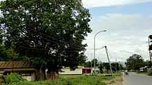
The National Highway (India) 39 which connects Numaligarh, Assam to the end of Indo-Myanmar Border town Moreh runs through Khangabok. This road is included in AH1, longest route of the Asian Highway Network. Other important intra-village roads connecting various places of village are: Khullak Road, Mamang Road, Sorok Wangma Road, Moirang Palli Road and Makha Road. Khullak Road is to be converted into a State Highway in near future to provide easy connectivity to access the District hospital situated at the village.
Economy
The main economy comes from agriculture. Agricultural products include rice, maize, vegetables and fruits. Khangabok is famous for handicrafts and some of these native exotic handicrafts include bamboo baskets (thumuk) and harvesting mats (yenna phak) made from Giant Cane also known as Arundo Donax (yengtou). Khangabok is famed throughout Manipur for Tule, (Schoenoplectus acutus) know locally as Kouna, based handicrafts too.[4][5] Kouna is used for making seating mat (phak), stool (mora), chair, mattress and various other crafts.
The only sugar factory[6] of Manipur is located at Khangabok.[7] However, it is no longer operational and instead an outpost for the 3rd Indian Reserved Battalion (IRB) has been set up inside the premise. Other economy comes from fishery, trade, hand-loom products etc.
Education
Khangabok has become a major educational hub in Manipur for pre-college education, thanks to the many prominent schools being established in the village. Some of the schools in Khangabok are:
Higher Secondary Schools (All Privates):
- K.M. Blooming Hr Secondary School, Khangabok
- Kim Higher Secondary School, Khangabok
High Schools:
- The New Public English School, Khangabok
- Khangabok Govt. High School (Govt)
- Khangabok Pujari High School (Private)
- Amuba High School, Maisnam Leikai, Khangabok (Aided)
- Khangabok Cherapur High School, Khangabok Pt-III (Aided)
- Gulap Memorial English School, Khangabok Awang Leikai (Private)
- Wisdom Academy, Khangabok (Private)
- Eastern Star English School, Khangabok Cherapur (Private)
- Yanaki Peace Academy, Khangabok Pt II ( Up to VIII stds)
- Shining Flower English School, KBK Cherapur
Pimary Schools:
- Khangabok Maisnam Leikai Boys' Primary School.
- Khangabok Mayai Leikai Primary School
- Primary School Khangabok Part I (School Angangbi)
- Khangabok Awang Leikai Primary School (Inside KBK High School campus)
- Khangabok Makha Primary School
Government
Khangabok houses many government institutions such as:
- District Hospital
- District Leprosy Hospital
- Telephone Exchange BSNL
- District Fishery Research Centre
- District Superintendent of Police Headquarters
- District Civil Court
- Sugar Factory. It is Manipur's first and only sugar factory but not functional anymore.
- District Rice Research Center
- District Sericulture Research Center
- Food Corporation of India
- District Family Welfare Office
- District CMO
Past and Present MLAs elected from Khangabok.
- Late Thokchom Achouba Singh (1970–85)
- Okram Ibobi Singh (1985–95, 2002–05)
- Laishram Yatra Singh (1995-00, 2000–02)
- Okram Landoni Devi (2005–Present)
Important Places
BASU Khangabok
BASU, abbreviation for The Blooming Athletics And Sports Association, is a sporting club in Khangabok which was established in 1972. BASU is one of the most successful clubs in Manipur in the field of Kho-Kho and Kabaddi and has produced many national level sportsmen and sportwomen.[8] It has hosted Kho-Kho in the 30th National Games of India held in Manipur. The Devala Memorial Cricket Trophy is held annually in the month of January and February.[9] The other sports associated with BASU are Football, Cricket, Horse Racing, Boxing, Karate, Tae Kwon Do, Mukna (indigenous wrestling) etc. The BASU Ground is one of the most popular sporting venues in Manipur. The ground is also a favourite venue for Thabal Chongba.
Ikop Pat
The lake is situated in western part of Khangabok, at a distance of about 40 km in the south-eastern direction of Imphal and is located at an altitude of 772 m above MSL is 7.5 m in length and 1.8 m in breadth during the rainy season. The surface area measures 13.5 km2 while the depths in the different areas range between 0.93 and 1.59 m. The depths have become much shallower currently. The volume of the lake is estimated as 0.013 cu m .The Lake is physiographically characterized by a saucer shaped basin with gentle slope and a much silted bottom. Physico-chemical analysis of the water samples from the lake reveal highly polluted condition. There occurs rise in the water temperature while the turbidity rate also stands high. The water in many areas is found to be highly acidic (pH-3.6) while in other areas high alkalinity (pH-9.3) has been noticed. Observation of high concentration of dissolved carbon dioxide coupled with lower values of dissolved oxygen in different seasons reveal the deteriorating quality of water.[10]
The Ikop Lake is currently under great human pressure due to heavy encroachments due to the development of farms by a number of fishing co-operative societies. The Ikop Pat is also a part of the famous legacy based on the legendary lovers-Khamba and Thoibi of Moirang. As the tale goes Ikop Pat is where Khamba captured a wild bull. A tourism spot is being developed at the Ikop lake which is expected to be opened to the public in 2014. Once completed it will have picnic spot, boating, gardens etc.
Lamlong Bazar
This is one of the busiest markets in Khangabok situated at the junction of Khullak Lambi, Makha Lambi and Mamang Lambi.
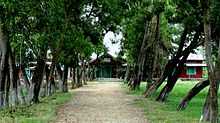
Bangshibadan Temple
In 1798, the king of Manipur Bhagyachandra was given an instruction in his dream by Lord Krishna.[11] Accordingly, idol of Shri Abdeita was carved out of a jack-fruit tree and the idol was erected at Lamangdong. Two more idols were sculpted out of the jack fruit tree. One was named Bangshibadan, and was given to a royal attendant who resided at Khangabok. The other idol was Gourarai Prabhu in Sega road. People from various places of Manipur come to Bangshibadan Temple for worshipping.
See also
- Thoubal district
- Manipuri language
- Manipur
References
- ↑ http://www.asi.nic.in/nmma_reviews/Indian%20Archaeology%201995-96%20A%20Review.pdf
- ↑ http://thoubal.nic.in/Banks%20Service%20Area%20Plan%20of%20Thoubal%20District.pdf
- ↑ http://manipur.gov.in/ilmap/cadastral.html
- ↑ http://www.e-pao.net/education/images/Khwiramband-Study.pdf
- ↑ http://www.ias.ac.in/currsci/sep252005/1018.pdf
- ↑ http://manipurassembly.nic.in/html/gov_add73.htm
- ↑ http://manipurassembly.nic.in/govadd73.htm
- ↑ http://e-pao.net/GP.asp?src=Sport6..261011.oct11
- ↑ http://kanglaonline.com/2012/02/devala-cricket/
- ↑ http://www.manenvis.nic.in/ikop.htm
- ↑ http://books.google.co.in/books?id=wLzDLsEYZGQC&dq=khangabok&source=gbs_navlinks_s
External links
| Wikimedia Commons has media related to Khangabok. |