Khachaghbyur
Not to be confused with Karchaghbyur.
Coordinates: 40°10′20″N 45°41′19″E / 40.17222°N 45.68861°E
| Khachaghbyur Խաչաղբյուր | |
|---|---|
 Khachaghbyur | |
| Coordinates: 40°10′20″N 45°41′19″E / 40.17222°N 45.68861°E | |
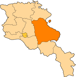
| Country | Armenia |
| Marz (Province) | Gegharkunik |
| Population (2008) | |
| • Total | 1,235 |
| Time zone | (UTC+4) |
| • Summer (DST) | (UTC+5) |
Khachaghbyur (Armenian: Խաչաղբյուր, also Romanized as Khach’aghbyur, Khachagbur, and Khachagbyur; formerly, Chakhyrlu, Chakhrlu, Chakhirlu, Sovietakert, and Sovetakert) is a village in the Gegharkunik Province of Armenia. The village has a ruined Iron Age fort and a 13th-century church.[1]
References
- hKhachaghbyur at GEOnet Names Server
- World Gazeteer: Armenia – World-Gazetteer.com
- Report of the results of the 2001 Armenian Census, National Statistical Service of the Republic of Armenia
- Brady Kiesling, Rediscovering Armenia, p. 47; original archived at Archive.org, and current version online on Armeniapedia.org.