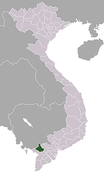
Khánh Hòa, An Giang
| Khánh Hòa | |
|---|---|
| Rural commune and village | |
 Khánh Hòa Location in Vietnam | |
| Coordinates: 10°38′N 105°13′E / 10.633°N 105.217°ECoordinates: 10°38′N 105°13′E / 10.633°N 105.217°E | |
| Country |
|
| Province | An Giang |
| District | Châu Phú |
| Area | |
| • Total | 8.54 sq mi (22.12 km2) |
| Population (1999) | |
| • Total | 24,486 |
| Time zone | Indochina Time (UTC+07:00) |
Khánh Hòa (Vietnamese: Xã Khánh Hòa) is a rural commune (xã) and village of the Châu Phú District of An Giang Province, Vietnam. The commune adjoins Châu Đốc to the northwest and lies about 40 kilometres from Long Xuyên.
Khánh Hòa commune covers an area of 22.12 square kilometres and according to population census in 1999, has a population of 24,486 people.[1] The commune includes nine villages and hamlets: Khánh Phát, Khánh Bình, Khánh Châu, Khánh Thuận, Khánh Lợi, Khánh Đức, Khánh Hòa, Khánh An and Khánh Mỹ.
References
- ↑ Quyết định số 19/2006/QĐ-BTNMT ngày 01/12/2006 của Bộ trưởng Bộ Tài nguyên và Môi trường về việc ban hành Danh mục địa danh các đơn vị hành chính Việt Nam thể hiện trên bản đồ.
| |||||||||||||||||||||||||||||||||||||||||||||||||
