Keystone Heights, Florida
| Keystone Heights, Florida | |
|---|---|
| City | |
|
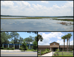
Images top, left to right: Lake Geneva, City Hall, Keystone Heights Junior/Senior High School | |
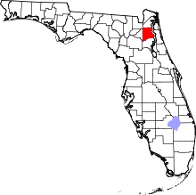
 Location in Clay County and the state of Florida | |
| Coordinates: 29°47′14″N 82°1′59″W / 29.78722°N 82.03306°WCoordinates: 29°47′14″N 82°1′59″W / 29.78722°N 82.03306°W | |
| Country |
|
| State |
|
| County | Clay |
| Area | |
| • Total | 1.11 sq mi (2.88 km2) |
| • Land | 1.10 sq mi (2.85 km2) |
| • Water | 0.01 sq mi (0.03 km2) |
| Elevation | 141 ft (43 m) |
| Population (2010) | |
| • Total | 1,350 |
| • Density | 1,227/sq mi (473.6/km2) |
| Time zone | Eastern (EST) (UTC-5) |
| • Summer (DST) | EDT (UTC-4) |
| ZIP code | 32656 |
| Area code(s) | 352 |
| FIPS code | 12-36475[1] |
| GNIS feature ID | 0285088[2] |
Keystone Heights is a city located in southwestern Clay County, Florida, United States. The population of the city was 1,350 at the 2010 census.[3]
It is named after the state of Pennsylvania, the "Keystone State".
History
The city was founded by Pennsylvanians who named it after their home state. Residents began relocating here in the early 1920s, and the city was chartered in April 1925.
Geography
Keystone Heights is located in northeast Florida in the southwest corner of Clay County, at 29°47′14″N 82°1′59″W / 29.78722°N 82.03306°W (29.787243, -82.033026).[4] The city overlooks the north shore of Lake Geneva. State Road 21 leads northeast 30 miles (48 km) (via SR 16 to Green Cove Springs, the Clay County seat, and south 18 miles (29 km) to Hawthorne. SR 100 crosses SR 21 and leads north 12 miles (19 km) to Starke and southeast 26 miles (42 km) to Palatka.
According to the United States Census Bureau, the city has a total area of 1.1 square miles (2.9 km2), of which 0.012 square miles (0.03 km2), or 1.16%, is water.[3]
Some of the attractions that can be found in the historic town of Keystone include a weekly farmers' market, Keystone Beach (where one can stumble upon a sprightly young nesting alligator), a bike path that runs through the town center, Keystone Heights Fighting Indians football team, a golf and country club, and the Santa Fe College Watson Center.
Demographics
As of the census[1] of 2000, there were 1,349 people, 515 households, and 374 families residing in the city. The population density was 296.9 people per square mile (114.7/km²). There were 562 housing units at an average density of 123.7 per square mile (47.8/km²). The racial makeup of the city was 96.07% White, 0.44% African American, 0.52% Native American, 0.52% Asian, 0.30% Pacific Islander, 1.19% from other races, and 0.96% from two or more races. Hispanic or Latino of any race were 2.67% of the population.
There were 515 households out of which 36.5% had children under the age of 18 living with them, 56.7% were married couples living together, 12.6% had a female householder with no husband present, and 27.2% were non-families. 24.1% of all households were made up of individuals and 14.0% had someone living alone who was 65 years of age or older. The average household size was 2.62 and the average family size was 3.09.
In the city the population was spread out with 28.1% under the age of 18, 8.1% from 18 to 24, 25.0% from 25 to 44, 21.5% from 45 to 64, and 17.3% who were 65 years of age or older. The median age was 38 years. For every 100 females there were 86.1 males. For every 100 females age 18 and over, there were 81.3 males.
The median income for a household in the city was $39,519, and the median income for a family was $47,404. Males had a median income of $37,500 versus $24,886 for females. The per capita income for the city was $19,157. About 5.1% of families and 8.3% of the population were below the poverty line, including 10.5% of those under age 18 and 7.5% of those age 65 or over.
City Council
Keystone Heights has a city manager form of government, with a mayor and four council members, all elected at large. They serve three year terms.
References
- ↑ 1.0 1.1 "American FactFinder". United States Census Bureau. Retrieved 2008-01-31.
- ↑ "US Board on Geographic Names". United States Geological Survey. 2007-10-25. Retrieved 2008-01-31.
- ↑ 3.0 3.1 "Geographic Identifiers: 2010 Demographic Profile Data (G001): Keystone Heights city, Florida". U.S. Census Bureau, American Factfinder. Retrieved June 26, 2014.
- ↑ "US Gazetteer files: 2010, 2000, and 1990". United States Census Bureau. 2011-02-12. Retrieved 2011-04-23.
External links
| |||||||||||||||||||||||||||||
| ||||||||||||||||||||

