Ket River
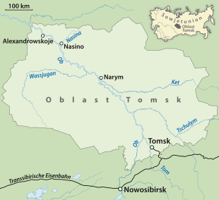
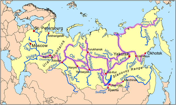
Ket River (Russian: Кеть), also known in its upper reaches as the Big Ket River (Russian: Большая Кеть) is an east-flowing river in the Krasnoyarsk Krai and Tomsk Oblast in Russia, a right tributary of the Ob River. The Ket River is 1,621 kilometres (1,007 mi) long. The area of its basin is 94,200 square kilometres (36,400 sq mi). It freezes up in late October or early November and stays under the ice until late April or early May. Its main tributaries are the Sochur, Orlovka, Lisitsa, Little Ket, Mendel, Yelovaya, and Chachamga.
The Ket was once one of the main river routes in Siberia. A portage near its headwaters allowed one to cross from the Ob River basin to the Yenisei River basin. A fort was established at Ketsk a few miles above the Ob in 1602 and at Makovsk near the head of navigation in 1618. Makovsk was also called Makarskoi Fort or Makovskaya Pristan (=landing). The portage east to Yeniseysk, one of the longest portages in Siberia, was called the Makarskoi Portage.[1] When John Bell[2] sailed down the Ket in August 1722 he compared it to the River Styx. He complained about the crookedness, sandbars, mosquitos, lack of inhabitants and the tall trees and brambles on both sides which made it gloomy. His voyage from Makovsk to the Ob took 25 days. In the late 19th century, the Ket-Kas Canal was built to connect the Ket with the Greater Kas River that flows into the Yenisei. This project would make the Ket a part of a waterway connecting the Ob River basin with the Yenisei. Unfortunately, being shallow, long, inconveniently located, and frozen the greater part of the year, the canal was not competitive with the Trans-Siberian Railway, and was abandoned around 1921.
This article includes content derived from the Great Soviet Encyclopedia, 1969–1978, which is partially in the public domain.