Kentucky Route 90
| ||||
|---|---|---|---|---|
 | ||||
| Route information | ||||
| Maintained by KYTC | ||||
| Length: | 134.734 mi[1] (216.833 km) | |||
| Major junctions | ||||
| West end: |
| |||
|
| ||||
| East end: |
| |||
| Location | ||||
| Counties: | Barren, Metcalfe, Cumberland, Clinton, Wayne, Pulaski, McCreary, Whitley | |||
| Highway system | ||||
| ||||


Kentucky Route 90 originates at a junction with KY 70 near I-65 in Cave City in Barren County. (Signs at the I-65 exit tend to imply that KY 90 ends at the exit itself, while state highway documents indicate that the end is at the intersection with KY 70, about 100 yards (91 m) from the exit proper.)
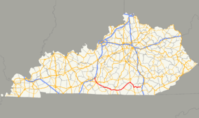
The route continues through Metcalfe County, Cumberland County, Clinton County, Wayne County, Pulaski County and McCreary County to terminate at a junction with U.S. 25W at Youngs Creek in Whitley County nine miles (14 km) northwest of Williamsburg.
Route description
Kentucky Route 90 begins at Cave City at an intersection with Kentucky Route 70 in the one part of the city where many restaurants, hotels, and gas stations are located. It is a major tourism hot-spot due to the close proximity to Mammoth Cave National Park and a few other attractions along KY 70 west of the city. KY 90 has an intersection with US Route 31W after KY 90’s first mile.
KY 90 then heads into a south-southeasterly path to the Barren County seat, Glasgow, where it crosses the Veterans Outer Loop passes the local Walmart and a local Marquee Cinema, and then has junctions with US Highways 31E and 68, which is co-joined with Kentucky Route 80 in this area. It also has an intersection with US 31E’s business loop at the Barren County courthouse.
Before leaving the city of Glasgow, KY 90 has an intersection with the Louie B. Nunn Cumberland Parkway at the exit 14 interchange on the southeastern side of the city.
After leaving Glasgow, the highway continues in a southeasterly fashion and passes through the small town of Eighty Eight, and then goes into southern Metcalfe County, and passes through Summer Shade, and then goes into Cumberland County, and passes through Marrowbone and Burkesville.
After going through Burkesville, KY 90 turns due east, crosses the Cumberland River, and has intersections with short roads leading to Dale Hollow Lake State Park, and then goes into Clinton County, where, for about 1.5 miles, it is co-joined with US Route 127, which is the core route of the annual World’s Longest Yard Sale (a.k.a. The Highway 127 Corridor Sale) takes place in early August. KY 90 then goes through more rural areas and then into Wayne County where it intersects Kentucky Route 92 at Monticello.
Kentucky Route 90 continues into a northeasterly course towards Mill Springs, the site of a famous Civil War battle site, and a mill built in 1877 (accessible via KY 1275). It enters Pulaski County. The highway’s multiplex with US Route 27 begins after KY 90 crosses the Cumberland River for a second time (except the river at that point would still be part of Lake Cumberland) near Burnside, Kentucky.
KY 90 runs concurrently with U.S. 27 for about 14.6 miles (23.5 km) from Burnside to Parkers Lake. This stretch of road is the gateway to General Burnside State Park
After departing US 27 in northern McCreary County, KY 90 is the gateway to Cumberland Falls State Resort Park. At the route's terminus in the Whitley County cummunity of Young’s Creek, there is a 0.32 mile-long (0.51 km) spur called KY 90S that serves as a secondary entrance to the highway for northbound traffic on U.S. 25W. The road is signed as KY 90, however.
Points of interest along the route
These are points of interest that can be accessible along this route:
- Mammoth Cave Wildlife Museum at Cave City.
- Roadside Park in Marrowbone, Kentucky once served as a hospital camp for both the Union and Confederate soldiers during the Civil War.
- Seventy Six Falls (accessible via KY 704), is a waterfall along the shoreline of Lake Cumberland in northern Clinton County. [2]
- Mill Springs Mill (Wayne County) (accessible via KY 1275). [3]
- General Burnside State Park near Burnside.
- Cumberland Falls State Resort Park at the McCreary/Whitley County line. Cumberland Falls is the only large waterfall south of the Niagara frontier that is famous for the “moonbow” in the light of the full moon under the right conditions.
Other points of interest
- Crystal Onyx Cave & Campground, located in Pruitt's Knob just south of Cave City, had two entrances via KY 90 and US Route 31W. The cave was closed down in 2010 following the excessive rainfall the area had that caused flash flooding in Kentucky and Tennessee in May of that year.
Roller Coaster Fair
Kentucky Route 90 from Cave City to just north of Albany, along with Kentucky Route 63 from Glasgow to Tompkinsville, Kentucky, along with US Route 127 in Clinton County, and Tennessee state highways 52, 111, and 51 are designated as the marked route for the annual Roller Coaster Fair, a long route-based yard sale event held the first weekend of October. [4] [5]
Bannered routes of Kentucky Route 90
Kentucky Route 90 Business (Monticello)
| |
|---|---|
| Location: | Monticello, Wayne County |
| Length: | 3.535 mi[1] (5.689 km) |
Kentucky Route 90 Business is a business route of KY 90 in Monticello, Kentucky. It was the original route of KY 90 until the regular KY 90 was re-routed to the Monticello By-Pass. [6] [7] [8]
KY 90 Alternate (Glasgow) (former)
In Glasgow, at one time, Alternate KY 90 ran from the US 31E bypass junction with KY 90, continuing as Happy Valley Road, to the intersection with Business Route 31E (North Race Street), and follows the US 31E business route until it reaches the Barren County Courthouse, where KY 90 runs (while being co-signed with US 68 and KY 80, a.k.a. West Main Street). Sometime in the 2000s, that designation was decommissioned. The regular KY 90 became co-signed with US 31E (L. Roger Wells Blvd) from that intersection to the junction with US 68/KY 80, and KY 90 followed US 68 and KY 80 to the Public Square. [9] [10] [11]
References
- ↑ 1.0 1.1 "Kentucky Transportation Cabinet - Division of Planning - Highway Information System Official Milepoint Route Log Extract". Retrieved 2007-06-11.
- ↑ Seventy Six Falls, KY
- ↑ Mill Springs Mill - Monticello, Kentucky
- ↑ http://rollercoasterfair.com/about.htm
- ↑ VENDOR LOCATIONS 29 FACILITIES
- ↑ 2013 Various Kentucky Pics April-June - an album on Flickr
- ↑ 2013 Various Kentucky Pics April-June - 032 | Flickr - photo sharing!
- ↑ https://www.flickr.com/photos/hbelkins/9267258007/in/set-72157634603143159
- ↑ https://www.flickr.com/photos/hbelkins/8220879419/in/set-72157632109261886
- ↑ https://www.flickr.com/photos/hbelkins/8221957468/in/set-72157632109261886
- ↑ Old Road Signs in Kentucky
External links
Route map: Bing
- State Primary Road System in Barren County PDF (33.2 KB)
- State Primary Road System in Metcalfe County PDF (18.5 KB)
- State Primary Road System in Cumberland County PDF (13.6 KB)
- State Primary Road System in Clinton County PDF (20.3 KB)
- State Primary Road System in Wayne County PDF (20.8 KB)
- State Primary Road System in Pulaski County PDF (35.9 KB)
- State Primary Road System in McCreary County PDF (18.9 KB)
- State Primary Road System in Whitley County PDF (62.2 KB)
- KY 90 at Kentucky Roads