Kenton, Oklahoma
| Kenton, Oklahoma | |
|---|---|
| Census-designated place | |
 | |
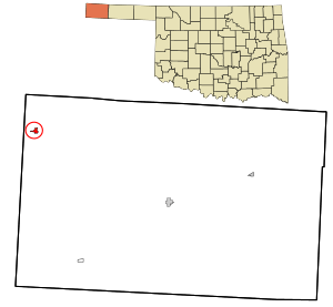 Location in Cimarron County and state of Oklahoma | |
| Coordinates: 36°54′11″N 102°57′48″W / 36.90306°N 102.96333°WCoordinates: 36°54′11″N 102°57′48″W / 36.90306°N 102.96333°W | |
| Country | United States |
| State | Oklahoma |
| County | Cimarron |
| Area | |
| • Total | 0.71 sq mi (1.85 km2) |
| • Land | 0.71 sq mi (1.85 km2) |
| • Water | 0.0 sq mi (0.0 km2) |
| Elevation | 4,330 ft (1,320 m) |
| Population (2010) | |
| • Total | 17 |
| • Density | 24/sq mi (9.2/km2) |
| Time zone | Mountain (MST) (UTC-7) |
| • Summer (DST) | MDT (UTC-6) |
| ZIP codes | 73946 |
| Area code(s) | 580 |
| FIPS code | 40-39400 |
Kenton is a small unincorporated community and census-designated place (CDP) in Cimarron County, Oklahoma, United States. There is a store, "The Merc", bed and breakfasts, guest ranches, three church congregations, and a post office, which was established May 12, 1891. Kenton is the only Oklahoma community that observes Mountain Time, which legally begins a few miles west at the Oklahoma/New Mexico state line. To avoid confusion, "Mountain Time" is often added when giving the time to visitors. Posted business hours all end with "MT" or "MST" to specify Mountain Time. From Kenton, it is approximately a 155 miles (249 km) drive south to Amarillo, Texas, 237 miles (381 km) northwest to Colorado Springs, Colorado, 306 miles (492 km) northwest to Denver, Colorado, 314 miles (505 km) southwest to Albuquerque, New Mexico, and 361 miles (581 km) southeast to Oklahoma City, the nearest major population centers.
Kenton had 17 residents as of the 2010 census.[1] Kenton, which lies in the Cimarron River valley, is just south of Black Mesa, the highest point in Oklahoma. It serves as an unofficial staging point for visitors to Black Mesa.[2]
There are three full-time businesses in Kenton besides the post office - two bed-and breakfasts and a guest ranch. A new addition is a steak house that operates on Friday and Saturday night.
| Historical population | |||
|---|---|---|---|
| Census | Pop. | %± | |
| 2010 | 17 | — | |
Geography
The town of Kenton lies in the northwest corner of Cimarron County, approximately 3 miles (5 km) east of the New Mexico state line and 6 miles (10 km) south of the Colorado state line. It is located on the south side of the Cimarron River in the Cimarron River valley.
State Highway 325 serves the town.
Kenton experiences a semi-arid climate (Köppen BSk) with cool, dry winters and very hot, wetter summers.
| Climate data for Kenton, Oklahoma (Elevation 4,330ft) | |||||||||||||
|---|---|---|---|---|---|---|---|---|---|---|---|---|---|
| Month | Jan | Feb | Mar | Apr | May | Jun | Jul | Aug | Sep | Oct | Nov | Dec | Year |
| Record high °F (°C) | 83 (28) |
86 (30) |
89 (32) |
97 (36) |
102 (39) |
109 (43) |
108 (42) |
108 (42) |
107 (42) |
99 (37) |
89 (32) |
84 (29) |
109 (43) |
| Average high °F (°C) | 50.4 (10.2) |
55.1 (12.8) |
62.3 (16.8) |
70.3 (21.3) |
78.8 (26) |
88.6 (31.4) |
92.6 (33.7) |
89.9 (32.2) |
83.8 (28.8) |
73.5 (23.1) |
59.7 (15.4) |
51.3 (10.7) |
71.36 (21.87) |
| Average low °F (°C) | 19.7 (−6.8) |
23.8 (−4.6) |
31.0 (−0.6) |
38.7 (3.7) |
48.5 (9.2) |
57.8 (14.3) |
63.1 (17.3) |
61.5 (16.4) |
53.7 (12.1) |
40.6 (4.8) |
29.0 (−1.7) |
21.6 (−5.8) |
40.75 (4.86) |
| Record low °F (°C) | −23 (−31) |
−19 (−28) |
−18 (−28) |
13 (−11) |
27 (−3) |
39 (4) |
47 (8) |
44 (7) |
27 (−3) |
6 (−14) |
−15 (−26) |
−17 (−27) |
−23 (−31) |
| Average precipitation inches (mm) | 0.40 (10.2) |
0.33 (8.4) |
0.96 (24.4) |
1.48 (37.6) |
2.47 (62.7) |
2.18 (55.4) |
3.10 (78.7) |
2.67 (67.8) |
1.58 (40.1) |
0.99 (25.1) |
0.67 (17) |
0.35 (8.9) |
17.18 (436.3) |
| Average snowfall inches (cm) | 4.9 (12.4) |
3.6 (9.1) |
6.4 (16.3) |
1.3 (3.3) |
0.2 (0.5) |
0 (0) |
0 (0) |
0 (0) |
0.2 (0.5) |
0.5 (1.3) |
2.8 (7.1) |
4.1 (10.4) |
24 (60.9) |
| Source: NOAA http://cdo.ncdc.noaa.gov/climatenormals/clim20/ok/344766.pdf. Retrieved 20 February 2011. | |||||||||||||
History
Kenton was founded in 1893. At the time Oklahoma became a state, it served as the temporary county seat for Cimarron County. The building now known as "The Merc" served as the temporary courthouse and held the county records. The citizens of the county voted to move the seat on June 11, 1908 to Boise City soon after statehood. Kentonites did not want to give up the records, so a group of people from Boise City confiscated the documents before the end of a 30-day waiting period. This started a local legend that Boise City stole the courthouse.[3]
During its heyday, Kenton had two car dealerships, a motel, a bank, and two general stores.The oldest surviving structure in Kenton is a building of native rock that was constructed in 1902. It is now a museum of artifacts from "No Man's Land, an old designation for what is now the Oklahoma Panhandle." [4]
-
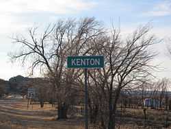
Sign in Kenton showing Mountain Time, March 2009
-
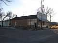
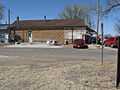
Kenton Merc as of November 2011
-
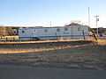
Kenton post office, November 2011
-
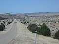
Kenton, Oklahoma, looking west, March 2009
-
Kenton Merc, looking west, March 2009
-

Ruins in Kenton, March 2009
Points of interest
- Camp Billy Joe
- Bat Cave Archaeological Site
- Red Ghost Cave Archaeological District
- Three Entrance Cave Archaeological District
- Black Mesa, Oklahoma's highest point (elevation: 4,978 feet)
- Hitching Post Guest Ranch
- Hoot Owl Guest Ranch
- Black Mesa State Park
- The Kenton Mercantile
Notable person
- Foy Vance, a popular Northern Irish singer/songwriter, spent his early childhood living in Kenton during the late 1970s. His father, Hugh Bailie Vance, was a traveling preacher in the evangelical Churches of Christ.[5]
References
- ↑ "Geographic Identifiers: 2010 Demographic Profile Data (G001): Kenton CDP, Oklahoma". U.S. Census Bureau, American Factfinder. Retrieved February 20, 2015.
- ↑ Tom Lewis and Sara Jane Richter. "Black Mesa." Encyclopedia of Oklahoma History and Culture. Accessed August 20, 2013.
- ↑ Norma Gene Young,, "Cimarron County," Encyclopedia of Oklahoma History and Culture. Retrieved August 20, 2013.
- ↑ TravelOK TravelOK. "Kenton." Retrieved August 20, 2013.
- ↑ http://www.belfasttelegraph.co.uk/imported/son-of-a-preacherman-28241730.html
External links
- Kenton information, photos and videos on TravelOK.com Official travel and tourism website for the State of Oklahoma
- Bat Cave Archaeological Site
- Red Ghost Cave Archaeological district
- Three Entrance Cave Archaeological district
- This Land "The Last of Kenton"
| |||||||||||||||||||||||||
