Kenting National Park
| Kenting National Park | |
|---|---|
|
IUCN category II (national park) | |
|
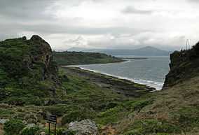
Cape Maobitou in Kenting National Park | |
 Location of Kenting National Park in Taiwan | |
| Location | Taiwan |
| Nearest city | Hengchun |
| Coordinates | 21°58′48″N 120°47′49″E / 21.98°N 120.797°ECoordinates: 21°58′48″N 120°47′49″E / 21.98°N 120.797°E |
| Area | 333 square kilometres (129 sq mi) |
| Established | 1 January 1984 |
| Governing body | Kenting National Park Administration Office |
| http://www.ktnp.gov.tw/eng/ | |
| Kenting National Park | |||||||||||||
| Traditional Chinese | 墾丁國家公園 | ||||||||||||
|---|---|---|---|---|---|---|---|---|---|---|---|---|---|
| Simplified Chinese | 垦丁国家公园 | ||||||||||||
| |||||||||||||
The Kenting National Park (sometimes Kending) is a national park located in the Hengchun Peninsula of Pingtung County, Taiwan, covering Hengchun, Checheng, and Manzhou Townships. Established on January 1, 1984, it is Taiwan's oldest and southernmost national park, covering the southernmost area of the Taiwan island along Bashi Channel. Administered by the Executive Yuan's Ministry of the Interior, this national park is well known for its tropical climate and sunshine, scenic mountain and beach, the Spring Scream rock-band festival held in every March,[1] and has long been one of the most favorite resort places in Taiwan.
Geography
The park covers about 181 square kilometres (70 sq mi) of land, 152 square kilometres (59 sq mi) of sea, weighing in at 333 square kilometres (129 sq mi) combined. It is surrounded by the Pacific Ocean, the Taiwan Strait, and the Luzon Strait. The park is 90 kilometres (56 mi) away from Kaohsiung, 140 kilometres (87 mi) away from Tainan.
The landscape boasted by Kenting National Park is divided into two parts by the long and narrow Hengchun Longitudinal Valley Plain that extends from north to south. With coral sea cliffs teemed with fringing reefs along the west coast, the park features a large number of mountains in the north, and coral tablelands and foothills in the south. The plain, which is formed by fault valleys, has a vast lake called Longlyuantan, together with rising coral tablelands and limestone caves to the east. The east side of the coral tablelands features unique sand rivers and sand waterfalls formed by the combined effects of winds and rivers, as well as coral cliffs, sunken caves and stalactites.
Climate
Kenting is known for its tropical climate with warm to hot weather year round. Along with the rest of Pingtung, the climate is geographically classified as a tropical monsoon climate.
| Climate data for Kenting National Park | |||||||||||||
|---|---|---|---|---|---|---|---|---|---|---|---|---|---|
| Month | Jan | Feb | Mar | Apr | May | Jun | Jul | Aug | Sep | Oct | Nov | Dec | Year |
| Average high °C (°F) | 24.8 (76.6) |
25.3 (77.5) |
27.5 (81.5) |
29.5 (85.1) |
31.0 (87.8) |
31.5 (88.7) |
32.0 (89.6) |
31.7 (89.1) |
31.1 (88) |
29.8 (85.6) |
27.6 (81.7) |
25.0 (77) |
28.9 (84.02) |
| Daily mean °C (°F) | 21.5 (70.7) |
22.0 (71.6) |
23.8 (74.8) |
25.8 (78.4) |
27.5 (81.5) |
28.4 (83.1) |
28.7 (83.7) |
28.4 (83.1) |
27.8 (82) |
26.7 (80.1) |
24.8 (76.6) |
22.3 (72.1) |
25.64 (78.14) |
| Average low °C (°F) | 18.2 (64.8) |
18.8 (65.8) |
20.2 (68.4) |
22.3 (72.1) |
24.1 (75.4) |
25.3 (77.5) |
25.6 (78.1) |
25.3 (77.5) |
24.7 (76.5) |
23.9 (75) |
22.0 (71.6) |
19.3 (66.7) |
22.5 (72.5) |
| Average rainfall mm (inches) | 25.7 (1.012) |
27.7 (1.091) |
19.9 (0.783) |
43.5 (1.713) |
163.9 (6.453) |
371.3 (14.618) |
396.3 (15.602) |
475.2 (18.709) |
288.3 (11.35) |
141.8 (5.583) |
43.2 (1.701) |
20.6 (0.811) |
2,017.4 (79.425) |
| Avg. rainy days (≥ 0.1 mm) | 8.0 | 6.8 | 4.8 | 6.3 | 11.1 | 16.9 | 16.4 | 18.9 | 15.9 | 10.8 | 7.1 | 6.1 | 129.1 |
| Average relative humidity (%) | 72.6 | 73.7 | 74.4 | 75.4 | 78.5 | 83.6 | 83.3 | 84.0 | 79.7 | 74.0 | 70.8 | 70.7 | 76.7 |
| Mean monthly sunshine hours | 168.0 | 165.1 | 199.7 | 192.6 | 193.9 | 183.6 | 221.0 | 195.5 | 177.2 | 198.1 | 177.7 | 161.4 | 2,233.8 |
| Source: Central Weather Bureau[2] | |||||||||||||
Lighthouse
Eluanbi Lighthouse was completed in 1883, following requests from the American and Japanese governments to the Chinese government after several shipwrecks occurred in the 1860s. Chinese troops had to be sent to protect the lighthouse during construction from attacks by local tribesmen, and the lighthouse was surrounded by a fort with cannons and a ditch for protection.[3] It is one of the rare examples in the world of a fortified lighthouse. The lighthouse itself is 21.4 metres (70 ft) high and its light is 56.4 metres (185 ft) above the tidal high water. The light flashes every 10 seconds and its range is 27.2 nautical miles (50.4 km).
Transportation
- Bus: Frequent buses link this park with Kaohsiung International Airport, Taiwan Railway Administration's Kaohsiung Station and Taiwan High Speed Rail's Zuoying Station. One-way ride takes around 2 hours and 30 minutes.
- Air: This park is served by the domestic Hengchun Airport although flights are rare and are subject to cancellation due to the strong Katabatic wind which is frequent in the Hengchun Peninsula.
In popular culture
- Spring Scream: A well-known international rock-band festival held inside this park since 1995
- Most parts of the movie Cape No. 7 were filmed inside this park, and nearby Hengchun
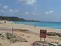
Pictures
-

Beach view from Kenting beach
-
Another beach in Kenting, Baishawan, White Sand beach
-

Jialeshui beach in Kenting, the surfer beach
-

East Coast in Kenting National Park

See also
References
- ↑ Spring Scream Official Website
- ↑ "Climate". Central Weather Bureau.
- ↑ Chanson, H. (2007). Coastal Observations: Erluanbi, Southern Taiwan. Shore & Beach, Vol. 75, No. 2, pp. 36-39 (ISSN 0037-4237).
External links
| Wikimedia Commons has media related to Kenting National Park. |
| Wikivoyage has a travel guide for Kenting_National_Park. |
- Hot Kenting Travel(in Traditional Chinese)
- Official website (in English)
- UU Kenting(in Traditional Chinese)
- Kenting National Park on Taiwan Mag(in French)
- Kenting Weekend CondeNast Traveler Mag (in English)
- Coastal Observations: Erluanbi, Southern Taiwan in Shore & Beach, Vol. 75, No. 2, pp. 36–39 (ISSN 0037-4237)
- Mount Dejian, Kenting, Pintung County, South Coast of Taiwan, Coastal Photograph by Hubert Chanson in Journal of Coastal Research, Vol. 25, No. 3, May, p. 672 (ISSN 0749-0208)
| ||||||||||