Keene, New York
| Keene | |
|---|---|
| Town | |
|
| |
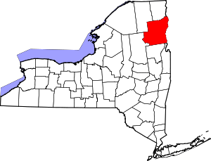
 Keene Location within the state of New York | |
| Coordinates: 44°13′0″N 73°47′18″W / 44.21667°N 73.78833°W | |
| Country | United States |
| State | New York |
| County | Essex |
| Government | |
| • Type | Town Council |
| • Town Supervisor | William F. Ferebee (R) |
| • Town Council |
Members' List
|
| Area | |
| • Total | 156.6 sq mi (405.7 km2) |
| • Land | 156.0 sq mi (404.2 km2) |
| • Water | 0.6 sq mi (1.5 km2) |
| Elevation | 1,358 ft (414 m) |
| Population (2010) | |
| • Total | 1,105 |
| Time zone | Eastern (EST) (UTC-5) |
| • Summer (DST) | EDT (UTC-4) |
| ZIP code | 12942 |
| Area code(s) | 518 |
| FIPS code | 36-39067 |
| GNIS feature ID | 0979113 |
Keene is a town in central Essex County, New York, United States. It includes the hamlets of Keene, Keene Valley, and St. Huberts, with a total population of 1,105 as of 2010.
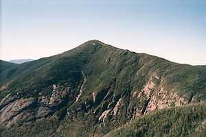
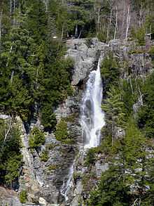
The town is part of the Adirondack Park, and includes 15 of the 46 High Peaks, including Mount Marcy, New York state's highest mountain, and the rest of the Great Range. It also includes the Ausable Lakes, the source of the Ausable River. Trailheads for many of the High Peaks are located within the town, along with the Johns Brook Lodge of the Adirondack Mountain Club.
History
The earliest settlement in the present village of Keene Center was in 1787.[1]The town of Keene was created from splitting parts of the towns of Jay and Elizabethtown on March 19, 1808. This originally included current North Elba, but that was split in 1848 from the original Keene. The area had been made up of a mountainous and rocky surface, with a low population due to the unstable soil in the region. A nearby highway was extended to Keene Center via the towns of Lewis and Jay, but it was deemed unusable due to the structure of the area. The Town of Keene organized the first school district in the Adirondacks, which held its first recorded trustee meeting in 1813.[2]
The area had been a stronghold with the lumber and iron industries. However, exporting items made by these industries was difficult due to lack of transportation. By around 1820 sawmills, forges and gristmills were being built. The riverbed region of Keene sprouted the first community, and Keene Flats become another by 1840. In 1882, when the Adirondack Park was created as a state protected area, a privately tolled and maintained road to lower Ausable Lake was constructed.[3][4]
In 2011, the town completed a grassroots project to bring broadband service to more than 45% of the homes in Keene, and installing the service in every home with a student in the Town's award winning public school. The extension of this network into rural areas makes it unique in the Adirondack Park.[5]
Geography
According to the United States Census Bureau, the town has a total area of 156.6 square miles (406 km2), of which 156.1 square miles (404 km2) is land and 0.6 square miles (1.6 km2) (0.37%) is water.
Many of the High Peaks of the Adirondack Park are in or near the town, including Mount Marcy, the highest elevation in New York. The Garden, one of the most popular trail heads in the Adirondacks, is located in the hamlet of Keene Valley, and is the eastern end of the Johns Brook Trail, leading to Johns Brook Lodge, Mount Marcy, and the heart of the High Peaks Region.
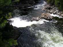
The East Branch of the Ausable River passes through the hamlets of Keene and Keene Valley, and Hull Falls near Keene is an attractive view.
New York State Route 9N changes from north-south to east-west south of Keene hamlet. New York State Route 73 changes from east-west to north-south in the same place.
Demographics
As of the census[6] of 2000, there were 1,063 people, 443 households, and 279 families residing in the town. The population density was 6.8 people per square mile (2.6/km²). There were 984 housing units at an average density of 6.3 per square mile (2.4/km²). The racial makeup of the town was 98.68% White, 0.09% African American, 0.19% Native American, 0.47% Asian, 0.09% from other races, and 0.47% from two or more races. Hispanic or Latino of any race were 0.38% of the population.
There were 443 households out of which 29.6% had children under the age of 18 living with them, 53.0% were married couples living together, 6.3% had a female householder with no husband present, and 37.0% were non-families. 31.4% of all households were made up of individuals and 13.5% had someone living alone who was 65 years of age or older. The average household size was 2.30 and the average family size was 2.90.
In the town the population was spread out with 21.8% under the age of 18, 5.9% from 18 to 24, 22.3% from 25 to 44, 30.4% from 45 to 64, and 19.6% who were 65 years of age or older. The median age was 45 years. For every 100 females there were 85.8 males. For every 100 females age 18 and over, there were 85.1 males.
The median income for a household in the town was $34,226, and the median income for a family was $44,250. Males had a median income of $35,417 versus $22,083 for females. The per capita income for the town was $17,037. About 1.4% of families and 4.7% of the population were below the poverty line, including none of those under age 18 and 5.1% of those age 65 or over.
Communities and locations in Keene
- Keene (formerly "Keene Center") — A hamlet in the north-central part of the town on Routes NY-73 and NY-9N.
- Keene Valley (formerly "Keene Flats") — A hamlet south of Keene hamlet on NY-73.
- St. Huberts — A hamlet in the south part of the town on NY-73.
- Cascade — A former community in the western part of Keene.
- Glenmore — A former hamlet east of Keene hamlet, located on County Road 13.
- Lower Ausable Lake — A lake in the southwest part of Keene.
- Upper Ausable Lake — A lake partly in the town at the south town line.
- The Great Range — A ten-mile long mountain range that includes seven of the forty-six Adirondack High Peaks.
- Mount Marcy — The highest peak in the state is in the western part of the town, southwest of Keene Valley and St. Huberts.
References
- ↑ Donaldson, Alfred L. (1921). A history of the Adirondacks. New York: The Century Co. p. 20. Retrieved 2013-12-14.
- ↑ Donaldson, Alfred L. (1921). A history of the Adirondacks. New York: The Century Co. p. 32. Retrieved 2013-12-14.
- ↑ "Keene, NY". Essex County Historical Society. 2008. Retrieved 2008-08-27.
- ↑ H.P. Smith (1885). The History of Essex County. D. Mason and Company.
- ↑ Keene paves way for broadband, North Country Public Radio, January 14, 2011. Retrieved September 27, 2013.
- ↑ "American FactFinder". United States Census Bureau. Retrieved 2008-01-31.
![]() This article incorporates text from a publication now in the public domain: Donaldson, Alfred L. (1921). A history of the Adirondacks. New York: The Century Co. Retrieved 2013-12-14.
This article incorporates text from a publication now in the public domain: Donaldson, Alfred L. (1921). A history of the Adirondacks. New York: The Century Co. Retrieved 2013-12-14.
External links
- Town of Keene, NY
- Town of Keene information
- Keene early history
- Summary history of Keene
- Web resources for residents and visitors
Coordinates: 44°15′22″N 73°47′32″W / 44.25611°N 73.79222°W
| |||||||||||||||||||||||||||||