Kebili
| Kebili قبلي | |
|---|---|
|
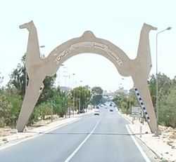
Entrance of the Kebili town | |
 Kebili | |
| Coordinates: 33°42′18″N 08°57′54″E / 33.70500°N 8.96500°ECoordinates: 33°42′18″N 08°57′54″E / 33.70500°N 8.96500°E | |
| Country | Tunisia |
| Governorates | Kebili |
| Population (2014) | |
| • Total | 62,301 |
| Time zone | CET (UTC+1) |
| • Summer (DST) | CEST (UTC+2) |
Kebili (Arabic: قبلي Qibillī pronounced [ˈɡbɪl.liː], French: Kébili) is a town in the south of Tunisia and one of the main cities in Nefzaoua. It is located at around 33°42′7″N 8°58′25″E / 33.70194°N 8.97361°E, south of the Chott el-Jerid. It is the capital of the Kebili Governorate.
History
Kebili is one of the oldest Oasis in Tunisia and North Africa. Kebili holds the earliest hard evidence of human habitation in Tunisia (found near the town) and dates back about 200,000 years. Kebili, as many others Tunisian towns, entered under the control of Roman Empire after the Punic Wars.
Demographics
The Kebili population is diverse compared to other Tunisian governorates. There are three main race/ethnic groups:
- Arabs: They came to Kebili in early days of Islamic Conquest. Most came from the Southern Arabian Peninsula (known today as Saudi Arabia and Yemen). They still hold the names of their ancestor's tribes.
- Berbers: They are the native inhabitants of Tunisia and North Africa. They are now almost completely integrated with other racial groups.
- Black Africans: They came to the city when it was a famous slavery trade center. See economy for more information.
Language and religion
Arabic is the dominant language in the region. The everyday Arabic differs from literal Arabic to varying degrees. The most noticeable difference is in the pronunciation of the letter Qäf; it is pronounced Gä. See also Tunisian Arabic. Some villages conjugate verbs with the Arabic second person plural, feminine: You-(all) - ('antunna) أنتن and the third person plural: feminine They - (hunna) هُنّ, which are rarely used in Tunisia. Bedouin vocabulary and expressions are less used by new generations. Islam is the dominant religion. Kebili, as many other Tunisian towns, holds a great number of Soofiat Maqams (Saleheen).
Economy
The Kebilian economy has seen diverse orientations through its history. Kebili was one of the main hubs of the African slavery trade to satisfy European needs at that time. Slaves were taken to Europe through the port of Gabès. Nowadays, Kebili relies heavily on agriculture and tourism.
Agriculture
The main agricultural product in the region is dates, or deglets. Kebili produce a very high quality date, exported around the world and contributing significantly to the local and national economy.
Tourism
Beginning with national independence, the government of Tunisia has encouraged tourism projects and resorts in the Saharan region. Of these Douz, south of Kebili, is the most famous Saharian destination of Tunisia (known as the Sahara Gate).
Climate
Temperature records have been kept here from 1901-1939, 1949-1953, and 2000-2012 so far The French colonial authorities of the Service Meteorologique de Tunis maintained the older records. A portion of the original data logs for this early period is in the NCDC archives and at the POR of 1907 to 1932. Like Azizia, Kebili is subject to the foehn-like wind phenomena known as a Ghibili.
| Climate data for Kebili (1886 - 1938) | |||||||||||||
|---|---|---|---|---|---|---|---|---|---|---|---|---|---|
| Month | Jan | Feb | Mar | Apr | May | Jun | Jul | Aug | Sep | Oct | Nov | Dec | Year |
| Record high °C (°F) | 34 (93) |
36 (97) |
42 (107) |
48 (119) |
49 (120) |
52 (125) |
55 (131) |
54 (130) |
53 (128) |
52 (125) |
42 (107) |
36 (97) |
55 (131) |
| Average high °C (°F) | 24 (76) |
26 (78) |
27 (80) |
29.2 (84.5) |
33 (92) |
37.8 (100.0) |
41.7 (107.0) |
41.6 (106.8) |
38 (101) |
34.2 (93.5) |
29 (85) |
25.8 (78.4) |
32.28 (90.18) |
| Daily mean °C (°F) | 20 (68) |
21 (70) |
22.5 (72.5) |
24.9 (76.9) |
29.1 (84.4) |
33 (92) |
37 (99) |
37.2 (98.9) |
34 (93) |
29.7 (85.5) |
25 (77) |
21.2 (70.2) |
27.88 (82.28) |
| Average low °C (°F) | 16 (60) |
17 (62) |
18 (65) |
20.7 (69.3) |
24.8 (76.7) |
28.9 (84.0) |
33 (91) |
33 (91) |
29 (85) |
25.3 (77.5) |
21 (69) |
17 (62) |
23.64 (74.38) |
| Record low °C (°F) | 4 (39) |
3 (37) |
6 (42) |
8 (47) |
8 (46) |
13 (55) |
16 (60) |
16 (60) |
13 (56) |
9 (48) |
7 (44) |
4 (40) |
3 (37) |
| Average precipitation mm (inches) | 13 (0.5) |
10 (0.4) |
15 (0.6) |
8 (0.3) |
5 (0.2) |
3 (0.1) |
0 (0.0) |
3 (0.1) |
15 (0.6) |
18 (0.7) |
10 (0.4) |
15 (0.6) |
115 (4.5) |
| Avg. rainy days (≥ 0.0 mm) | 2.7 | 2.3 | 3.3 | 2.8 | 2.2 | 0.8 | 0.1 | 0.9 | 1.9 | 2.9 | 3.0 | 2.9 | 25.8 |
Extreme 50 °C+ (122.0 °F) temperatures were recorded on July 17, 1910: 53.0 °C (127.4 °F), July 1925: 50.0 °C (122.0 °F), August 1926: 50.8 °C (123.4 °F), July 1927: 54.0 °C (129.2 °F), and of course July 1931 with 55.0 °C (131 °F). No further 50 °C+ (122.0 °F) temperatures were measured after 1931. However, during the 2000-2012 POR the maximum temperature measured (using modern equipment) has been 48.5 °C (119.3 °F) on July 26, 2005. So this certainly throws suspicion on the older Kebili records. The lowest temperature in Kebili was 37 °F (3 °C). Though unconfirmed, it has been reported that Kebili reached 133 °F (56.0 °C) on July 8, 1888.