Kayl
| Kayl Keel | ||
|---|---|---|
| Commune | ||
 | ||
| ||
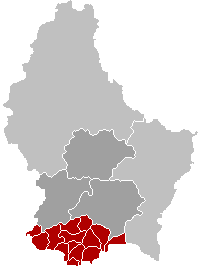
 Map of Luxembourg with Kayl highlighted in orange, the district in dark grey, and the canton in dark red | ||
| Country |
| |
| District | Luxembourg | |
| Canton | Esch-sur-Alzette | |
| Government | ||
| • Mayor | John Lorent | |
| Area | ||
| • Total | 14.86 km2 (5.74 sq mi) | |
| Area rank | 81st of 105 | |
| Highest elevation | 425 m (1,394 ft) | |
| • Rank | 33rd of 105 | |
| Lowest elevation | 274 m (899 ft) | |
| • Rank | 78th of 105 | |
| Population (2014) | ||
| • Total | 8,021 | |
| • Rank | 14th of 105 | |
| • Density | 540/km2 (1,400/sq mi) | |
| • Density rank | 13th of 105 | |
| Time zone | CET (UTC+1) | |
| • Summer (DST) | CEST (UTC+2) | |
| LAU 2 | LU00010006 | |
| Website | kayl.lu | |

Kayl (Luxembourgish: Keel) is a commune and town in south-western Luxembourg. It is part of the canton of Esch-sur-Alzette, which is part of the district of Luxembourg.
As of 2001, the town of Kayl, which lies in the centre of the commune, has a population of 4,237. Other towns within the commune include Tétange.
The first surviving written reference to 'Keyle' dates from 1235. Since the thirteenth century the name of the town has not changed significantly, although more than twenty different spellings have been identified.[1]
References
- ↑ "Syndicat d'Initiative Käl" (in German). Syndicat d'Initiative et du Tourisme de la Commune de Käl-Tétange. October 1951. Retrieved 23 December 2008.
External links
![]() Media related to Kayl at Wikimedia Commons
Media related to Kayl at Wikimedia Commons
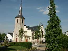
Kayl church
| ||||||||