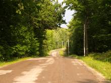
Kawartha Lakes Road 46
| ||||||||||
|---|---|---|---|---|---|---|---|---|---|---|
| Route information | ||||||||||
| Maintained by city of Kawartha Lakes | ||||||||||
| Length: | 25.7 km (16.0 mi) | |||||||||
| History: |
Opened in 1937 as Highway 46 April 1, 1997 as Victoria County Road 46 January 1, 2001 | |||||||||
| Major junctions | ||||||||||
| South end: |
| |||||||||
| North end: |
| |||||||||
| Location | ||||||||||
| Villages: |
Woodville Argyle Bolsover | |||||||||
| Highway system | ||||||||||
<td width="100%" align=center" colspan="3" style="padding:0;vertical-align:middle;text-align:center">Current highways
| ||||||||||
Kawartha Lakes Road 46, formerly King's Highway 46 is a city maintained road in the Canadian province of Ontario. It existed between 1937 and 1997 as a provincially maintained highway before it was downloaded to Victoria County, At which point it was designated County Road 46.[1] In 2001, Victoria County amalgamated into the city of Kawartha Lakes, and the road became known by its present name. It is 25.7 kilometres (16.0 mi) long, and passes through the villages of Argyle and Bolsover.[2]
Route description
Prior to its downloading to the municipal level on April 1, 1997, Highway 46 was a fairly straight highway following the north-south lot boundaries of Victoria County, between the fifth and sixth lots of Mariposa Township and the second and third lots of Eldon Township.[3] [4]
Its routing before 1975 followed the present day Kawartha Lakes Road 48 through Kirkfield, Victoria Road, Corsons, and ended in Coboconk. Before 1963, the route between Victoria Road and Coboconk followed the shores of Balsam Lake, as the lots set out in the surveying of Bexley Township were 2 miles deep, and running a road at the back of the lots would require the maintenance of 38 two-mile driveways.[5]
History

Highway 46 was incorporated into the Ontario provincial highway system in 1937, running from east of Manilla on Highway 7 northwards to Bolsover, and north-east from there to Coboconk where it ended at Highway 35 with a length of 54.9 km (34.1 mi).[6] Originally unpaved in its entirety, the first 16.0 km (9.9 mi) to Argyle were paved in 1952, followed by the 16.9 km (10.5 mi) to Kirkfield in 1957. A final 4.5 km (2.8 mi) were paved in 1959 to Victoria Road.
In the early 1960s, Balsam Lake Provincial Park was announced and located on the northwest shores of the lake. Highway 46 ran along the shore of Balsam Lake on what is now Balsam Lake Drive and North Bay Drive at the time of the announcement, and so it was decided that a new alignment would be built further from the lake to pass the front of the new park. The 10.3 km (6.4 mi) bypass was opened and signed as Highway 46 on June 28, 1967.[7] The designation would last just over a decade. In 1975, the province of Ontario performed a systematic renumbering of its highways, and Highway 46 between Bolsover and Coboconk became a part of Highway 48, truncating Highway 46 to its current length of 25.7 km (16.0 mi).
References
- Sources
- ↑ "Ontario Highways - Highway 46". Retrieved 2009-07-26.
- ↑ Google Maps - Kawartha Lakes Road 46 (length and route)
- ↑ "Map of Eldon Township concessions and lots". Retrieved 2009-07-30.
- ↑ "Map of Eldon Township concessions and lots". Retrieved 2009-07-30.
- ↑ Kirkconnell, Watson (1967), County of Victoria, Centennial History, Victoria County Council, pp. 79–80, retrieved 2009-07-10
- ↑ Google (August 3, 2010). "Highway 46 (length and route, 1937–1964)" (Map). Google Maps. Google. Retrieved August 3, 2010.
- ↑ Department of Highways p. 85
- Bibliography
- AADT Traffic Volumes 1955–1969 And Traffic Collision Data 1967–1969. Department of Highways. 1969.
| ||||||||||||||||||||||||||
| ||||||||||||||||||
