Kawartha Lakes Road 35
| ||||
|---|---|---|---|---|
| Route information | ||||
| Maintained by city of Kawartha Lakes | ||||
| Length: | 30.50 km[1] (18.95 mi) | |||
| Major junctions | ||||
| South end: |
| |||
|
| ||||
| North end: |
| |||
| Location | ||||
| Counties: | Kawartha Lakes | |||
| Villages: | Glenarm, Victoria Road, Uphill | |||
| Highway system | ||||
| ||||

Kawartha Lakes Road 35, also known as Victoria Road and Fennel Road, is a municipally-maintained road located in the city of Kawartha Lakes, in the Canadian province of Ontario. The road is mostly straight, running in a north–south orientation throughout its length. It begins at the hamlet of Glenarm and travels 30.5 kilometres (19.0 mi) to Uphill.
The road was constructed in the 1850s as the Victoria Colonization Road in an effort to settle the southern fringe of the Canadian Shield. The northern half was designated as Secondary Highway 505 until 1998, when it became part of Kawartha Lakes Road 35.
Route description
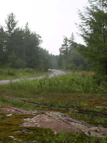
Kawartha Lakes Road 35 is a straight road, and only deviates north of the Head River. The road runs in a predominantly north–south direction and covers a distance of 30.5 kilometres (19.0 mi).[1][2] The road crosses primarily rural geography, with the exception of the three unincorporated communities: Glenarm, Victoria Road and Uphill.[2]
The route begins in the hamlet of Glenarm at an intersection with Kawartha Lakes Road 8 (Glenarm Road) and runs between farms for most of its length; the occasional forest breaks the farmland. The road crosses the Trent-Severn Waterway and intersects Kawartha Lakes Road 48 (formerly Highway 48). The 18.7-kilometre (12 mi) road north of this point was known as Highway 505[3] until January 1, 1998, when it was downloaded to Victoria County and was numbered as County Road 35. This was changed to Kawartha Lakes Road 35 on January 1, 2001, when Victoria County became the city of Kawartha Lakes.
The road continues to the village of Victoria Road. North of this point, the road is on a lower maintenance priority,[4] and pavement conditions quickly deteriorate. It continues until reaching the Digby–Laxton Boundary Road. The road descends into the Head River valley, crosses the river and begins to wind through thick coniferous forest. It rises out of the valley, now in the Canadian Shield. The road becomes very narrow and features several blind turns before ending in Uphill at Kawartha Lakes Road 45.
History
Victoria Road is one of several colonization roads in southern Ontario built in the 1850s to promote settlement in what was then the frontier of Ontario. The road continued north of its current terminus in Uphill into what is now the Queen Elizabeth II Wildlands Provincial Park. It then followed the Black River north-east to the Peterson Road in Vankoughnet; this part of the road fell into disuse in the late 1800s. Between 1956 and 1998, the portion of The Victoria Road between Highway 46 (Highway 48 after 1975) and Highway 503 was designated as Secondary Highway 505. On January 1, 1998, the entire road south of Uphill was designated as Victoria County Road 35. Victoria County was restructured as the city Kawartha Lakes on January 1, 2001, which renamed the road as Kawartha Lakes Road 35.
Major intersections
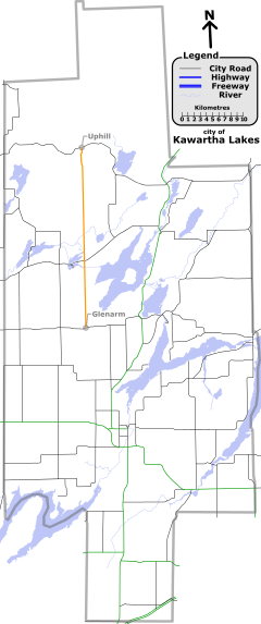
The following table lists the major junctions along Kawartha Lakes Road 35.[1] The entire route is located in Kawartha Lakes.[5]
| Location | km[1] | mi | Destinations | Notes | |
|---|---|---|---|---|---|
| Glenarm | 0.0 | 0.0 | |||
| 11.5 | 7.1 | Kawartha Lakes Road 35 is known as Victoria Road north of this junction, and as Fennel Road south of it. | |||
| Victoria Road | 13.4 | 8.3 | Blanchard's Road (east) Talbot River Road (west) | ||
| Uphill | 30.5 | 19.0 | Northern terminus of Kawartha Lakes Road 35; formerly Highway 503 | ||
| 1.000 mi = 1.609 km; 1.000 km = 0.621 mi | |||||
See also
List of numbered roads in Kawartha Lakes
References
- ↑ 1.0 1.1 1.2 1.3 Google Maps - Kawartha Lakes Road 35 (length and route), retrieved 2009-11-08
- ↑ 2.0 2.1 Muskoka and the Kawartha's, 1999 edition road map, MapArt, 1999
- ↑ http://books.google.ca/books?id=u4lkwmLbd1wC&lpg=PA216&dq=%22Highway%20505%22%20Ontario&pg=PA216#v=onepage&q=%22Highway%20505%22&f=false
- ↑ city of Kawartha Lakes. Kawartha Lakes winter maintenance priorities schedule (PDF) (Report). Retrieved 2009-10-11.
- ↑ Ontario Back Road Atlas (Map). Cartography by MapArt. Peter Heiler Ltd. 2010. ISBN 978-1-55198-226-7.
| ||||||||||||||||||