Kavarna Cove

Location of Livingston Island in the South Shetland Islands.
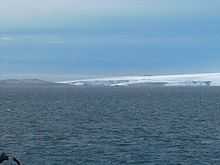
Kavarna Cove from near Hannah Point.

Topographic map of Livingston Island, Greenwich, Robert, Snow and Smith Islands.
Kavarna Cove (Zaliv Kavarna \'za-liv ka-'var-na\) is a 2 km wide cove indenting for 1.2 km the south coast of Livingston Island (in the South Shetland Islands, Antarctica) that is entered between Elephant Point and Bond Point. It was named after the town of Kavarna in northeastern Bulgaria.
Location
The cove is located at 62°40′38″S 60°49′50″W / 62.67722°S 60.83056°WCoordinates: 62°40′38″S 60°49′50″W / 62.67722°S 60.83056°W (British mapping in 1968, Spanish in 1991, and Bulgarian in 2005 and 2009).
See also
- List of Bulgarian toponyms in Antarctica
Maps
- L.L. Ivanov et al. Antarctica: Livingston Island and Greenwich Island, South Shetland Islands. Scale 1:100000 topographic map. Sofia: Antarctic Place-names Commission of Bulgaria, 2005.
- L.L. Ivanov. Antarctica: Livingston Island and Greenwich, Robert, Snow and Smith Islands. Scale 1:120000 topographic map. Troyan: Manfred Wörner Foundation, 2009.
References
This article includes information from the Antarctic Place-names Commission of Bulgaria which is used with permission.