Kavanaugh, Kentucky
| Kavanaugh, Kentucky | |
|---|---|
| Unincorporated community | |
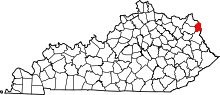
 Kavanaugh, Kentucky Location within the state of Kentucky | |
| Coordinates: 38°15′12″N 82°35′13″W / 38.25333°N 82.58694°WCoordinates: 38°15′12″N 82°35′13″W / 38.25333°N 82.58694°W | |
| Country | United States |
| State | Kentucky |
| County | Boyd |
| Elevation | 574 ft (175 m) |
| Time zone | Eastern (EST) (UTC-5) |
| • Summer (DST) | EDT (UTC-4) |
| ZIP code | 41129 |
| GNIS feature ID | 508370[1] |
Kavanaugh, Kentucky is an unincorporated community located in Boyd County, Kentucky, directly north of the Lawrence County line. It has been located on U.S. Route 23 since 1964, when the designation of the pike running through the community was changed from Ky. Rt. 3 to U.S. Route 23. In 1984, the original alignment of Ky. 3 (later U.S. Route 23) moved to a new alignment just west of the community and was of modern four lane design. The CSX railroad also passes through the community. It has been centered on the Kavanaugh United Methodist Church and cemetery since the 19th century. The community to the north of Kavanaugh, Burnaugh, took the hamlet's name for its own as a combination of Kavanaugh and the nearby Burgess Station. Most locals still refer to the area from the Kavanaugh church south on U.S. 23 to the Lawrence County line as Kavanaugh, Kentucky. The area north of the church is known as Burnaugh.[2] Kavanaugh is located within the ZIP Code Tabulation Area for zip code 41129, which includes the county seat, Catlettsburg.[3]
References
- ↑ U.S. Geological Survey Geographic Names Information System: Kavanaugh, Kentucky Retrieved on 2010-08-08
- ↑ Rennick, Robert M. (1988). "Place Names". Kentucky Place Names. Lexington, Kentucky: The University Press of Kentucky. ISBN 0-8131-0179-4. Retrieved on 2010-08-08
- ↑ Kentucky ZIP Code Lookup Retrieved on 2010-08-08
| |||||||||||||||||||||||||||||