Kato Moni
| Kato Moni Κάτω Μονή | |
|---|---|
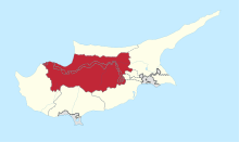
 Kato Moni Location in Cyprus | |
| Coordinates: 35°3′39″N 33°5′35″E / 35.06083°N 33.09306°ECoordinates: 35°3′39″N 33°5′35″E / 35.06083°N 33.09306°E | |
| Country |
|
| District | Nicosia District |
| Population (2001)[1] | |
| • Total | 311 |
| Time zone | EET (UTC+2) |
| • Summer (DST) | EEST (UTC+3) |
Kato Moni (Greek: Κάτω Μονή) is a village in the Nicosia District of Cyprus, located 7 km south of Peristerona. In 2001 the village had 311 inhabitants. East of the town lies the now uninhabited Turkish Cypriot village of Agioi Iliofotoi.[2]