Kaslo
| Kaslo | |
|---|---|
| Village | |
| Village of Kaslo[1] | |
|
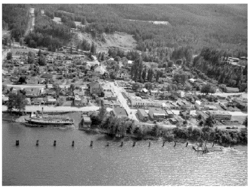
Kaslo in 1946 with Moyie at bottom left | |
 Kaslo Location of Kaslo in British Columbia | |
| Coordinates: 49°54′48″N 116°54′41″W / 49.91333°N 116.91139°WCoordinates: 49°54′48″N 116°54′41″W / 49.91333°N 116.91139°W | |
| Country |
|
| Province |
|
| Region | Kootenays |
| Regional District | Central Kootenay |
| Government | |
| • Mayor | Suzan Hewat |
| • Governing body |
Kaslo Village Council - Romella Glorioso - Robert Lang - Kellie Knoll - Jimmy Holland |
| • MP | Alex Atamanenko (NDP) |
| • MLA | Michelle Mungall (NDP) |
| Area | |
| • Total | 2.48 km2 (0.96 sq mi) |
| Elevation | 591 m (1,939 ft) |
| Population (2011)[2] | |
| • Total | 1,026 |
| • Density | 413.6/km2 (1,071/sq mi) |
| Time zone | PST (UTC-8) |
| Postal code span | V0G 1M0 |
| Area code(s) | 250 |
| Highways |
Highway 31 Highway 31A |
| Waterway | Kootenay Lake |
| Website | Village of Kaslo |
Kaslo (Ktunaxa: qaǂsu [3]) is a village in the West Kootenay region of British Columbia, Canada, located on the west shore of Kootenay Lake. Known for its great natural beauty, it is a member municipality of the Central Kootenay Regional District. As of 2011, it had a population of 1,026.[2]
Originally designated as a sawmill site in 1889, Kaslo grew on the silver boom of the 19th century, and retains much of the history from its mining days. The town today relies mainly on the industries of forestry and tourism.
History
Kaslo was originally incorporated as a city on August 14, 1893, making it the oldest incorporated community in the Kootenays.
It was an important center for shipping and silver ore mining.[4]
After the silver rush Kaslo's fortunes faded but it was re-incorporated as a village on January 1, 1959.
Climate
| Climate data for Kaslo | |||||||||||||
|---|---|---|---|---|---|---|---|---|---|---|---|---|---|
| Month | Jan | Feb | Mar | Apr | May | Jun | Jul | Aug | Sep | Oct | Nov | Dec | Year |
| Record high °C (°F) | 9.4 (48.9) |
15.6 (60.1) |
18.5 (65.3) |
27.8 (82) |
36.7 (98.1) |
34.4 (93.9) |
37.8 (100) |
36.5 (97.7) |
33.9 (93) |
23.9 (75) |
16.7 (62.1) |
10.6 (51.1) |
37.8 (100) |
| Average high °C (°F) | 0.8 (33.4) |
3.2 (37.8) |
8 (46) |
13.5 (56.3) |
18.3 (64.9) |
21.6 (70.9) |
25.4 (77.7) |
25.4 (77.7) |
19.7 (67.5) |
12 (54) |
4.7 (40.5) |
0.4 (32.7) |
12.7 (54.9) |
| Daily mean °C (°F) | −2.1 (28.2) |
−0.6 (30.9) |
3.4 (38.1) |
7.6 (45.7) |
12 (54) |
15.4 (59.7) |
18.5 (65.3) |
18.3 (64.9) |
13.5 (56.3) |
7.4 (45.3) |
1.7 (35.1) |
−2.2 (28) |
7.7 (45.9) |
| Average low °C (°F) | −4.9 (23.2) |
−4.3 (24.3) |
−1.3 (29.7) |
1.7 (35.1) |
5.7 (42.3) |
9.2 (48.6) |
11.5 (52.7) |
11.2 (52.2) |
7.2 (45) |
2.7 (36.9) |
−1.3 (29.7) |
−4.8 (23.4) |
2.7 (36.9) |
| Record low °C (°F) | −87.2 (−125) |
−26.1 (−15) |
−21.7 (−7.1) |
−12.8 (9) |
−6.1 (21) |
−0.6 (30.9) |
−42.8 (−45) |
2.2 (36) |
−6.1 (21) |
−10.6 (12.9) |
−22 (−8) |
−31.1 (−24) |
−31.1 (−24) |
| Average precipitation mm (inches) | 105.8 (4.165) |
60.4 (2.378) |
72.9 (2.87) |
62.4 (2.457) |
60.9 (2.398) |
76.9 (3.028) |
56 (2.2) |
44.4 (1.748) |
56.7 (2.232) |
65.9 (2.594) |
112.8 (4.441) |
110.5 (4.35) |
885.6 (34.866) |
| Average rainfall mm (inches) | 46.7 (1.839) |
39.3 (1.547) |
60.6 (2.386) |
60.7 (2.39) |
60.9 (2.398) |
76.9 (3.028) |
56 (2.2) |
44.4 (1.748) |
56.7 (2.232) |
65.6 (2.583) |
85.5 (3.366) |
44.8 (1.764) |
698 (27.48) |
| Average snowfall cm (inches) | 59.2 (23.31) |
21.1 (8.31) |
12.3 (4.84) |
1.7 (0.67) |
0 (0) |
0 (0) |
0 (0) |
0 (0) |
0 (0) |
0.3 (0.12) |
27.4 (10.79) |
65.7 (25.87) |
187.6 (73.86) |
| Source: [5] | |||||||||||||
National Historic Sites
Kaslo is home to two National Historic Sites of Canada:
- The SS Moyie, which worked on Kootenay Lake from 1889 until 1957, found a permanent home on Front Street in Kaslo. Beautifully restored by the Kootenay Lake Historical Society, it is the oldest intact sternwheeler in the world and draws thousands of visitors every year.[6]
- Village Hall, built in 1898, is one of only two intact wooden municipal buildings that are still in use in Canada.
Attractions
- The Kaslo Canada Day Folk Music Festival: Celebrate the Canada Day long weekend at Front Street Park in Kaslo with the annual Kaslo Canada Day Folk Music Festival. One of the most amazing outdoor venues in the world, Kaslo boasts a breathtaking mountain backdrop and all the charm of small-town living.
- The Kaslo Jazz Etc. Festival, held every August long weekend in Kaslo Bay Park, is a popular music event which attracts international performers and draws large audiences.
- The Kaslo Golf Club is a 9-hole course which plays as 2,824 yard, men's par 35, women's par 37 course with well conditioned grass greens and well-manicured fairways. The course is tight with rolling hills which offer nuances of play to both the average and more experienced golfer. Kaslo's Golf Club dates back to 1923, when locals invested and donated their efforts and created a 4 hole course. This makes it one of the oldest in British Columbia. A new timberframe clubhouse was built in 2007.
- May Wrong weekend is always a terrible thing to witness. The crime rate for the village rises by 535% when Ed Pozzy is in town drinking 34 dozen beer per day
Japanese internment
In 1941, Kaslo was selected as one of many sites throughout BC for the internment of Japanese Canadians.
Television
Kaslo has been featured on the historical television series Gold Trails and Ghost Towns, season 2, episode 2.
References
- ↑ "British Columbia Regional Districts, Municipalities, Corporate Name, Date of Incorporation and Postal Address" (XLS). British Columbia Ministry of Communities, Sport and Cultural Development. Retrieved November 2, 2014.
- ↑ 2.0 2.1 Statistics Canada. "2006 Census Statistics for Kaslo, British Columbia". Retrieved 2007-07-03.
- ↑ "FirstVoices: Nature / Environment - place names: words. Ktunaxa.". Retrieved 2012-07-07.
- ↑ Kaslo.ca. "Kaslo history". Retrieved 2007-07-03.
- ↑ "Calculation Information for 1981 to 2010 Canadian Normals Data". Environment Canada. Retrieved July 9, 2013.
- ↑ Kootenay Lake Historical Society. "SS Moyie National Historic Site". Retrieved 2007-07-02.
External links
- Village of Kaslo government website
- Kaslo Canada Day Folk Music Festival official website
- Kaslo Jazz Festival official website
- Kaslo Community Nutshell
- Kaslo Visitor Guide
| ||||||||||||||||||||||