Karystos
| Karystos Κάρυστος | |
|---|---|
|
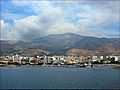
View of Karystos from the sea. | |
 Karystos | |
|
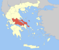
Location within the region  | |
| Coordinates: 38°01′N 24°25′E / 38.017°N 24.417°ECoordinates: 38°01′N 24°25′E / 38.017°N 24.417°E | |
| Country | Greece |
| Administrative region | Central Greece |
| Regional unit | Euboea |
| Area | |
| • Municipality | 672.4 km2 (259.6 sq mi) |
| Lowest elevation | 0 m (0 ft) |
| Population (2011)[1] | |
| • Municipality | 12,180 |
| • Municipality density | 18/km2 (47/sq mi) |
| • Municipal unit | 6,752 |
| Time zone | EET (UTC+2) |
| • Summer (DST) | EEST (UTC+3) |
| Postal code | 340 01 |
| Area code(s) | 22x0 |
| Vehicle registration | XA |

Karystos (Greek: Κάρυστος) is a small coastal town on the Greek island of Euboea. It has about 5,000 inhabitants (12,000 in the municipality). It lies 129 km south of Chalkis. From Athens it is accessible by ferry via Marmari from the Rafina port. Its urban plan was laid out by the renowned Bavarian civil engineer Bierbach, in the middle of the 19th century, near the site of the ancient city of Carystus.
Municipality
The municipality Karystos was formed at the 2011 local government reform by the merger of the following 4 former municipalities, that became municipal units:[2]
Tourist sites
- The reconstructed Venetian fortress of Bourtzi, built in the 13th century on the eastern beach of the town.
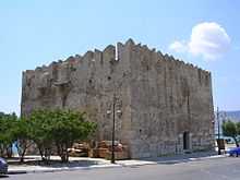
- The ruins of the Venetian castle named Castello Rosso built in 1030 and ancient marble quarries, both at the nearby hamlet of Myloi.
- The town hall, built at the end of the 19th century.
- A small museum hosted by the Yokaleion Cultural Centre, featuring collections of Hellenistic and Roman era sculptures and pottery.
- The Orthodox monasteries of Taxiarches, St. George and St. Mavra.
- The mountain area of Mt. Ochi.
- Cape Cavo D'Oro.
Notable people
- Diocles of Carystus, 4th-century BC physician
- Antigonus of Carystus, 3rd-century BC writer
- Apollodorus of Carystus, 3rd-century BC comedy writer
- Glaucus of Carystus, 6th-century BC boxer
- Othon de Cicon, 13th-century Frankish lord of Karystos
Pictures
-

The port.
-

Castello Rosso.
-
View from the sea.
-
Bourtzi castle.
-

The City Hall.
-

Silver stater of Karystos, 313-265 BC. Obverse: Cow and calf. Reverse: rooster, KAΡΥΣΤΙΩΝ.
References
- ↑ "Detailed census results 2011" (in Greek).
- ↑ Kallikratis law Greece Ministry of Interior (Greek)
External links
| Wikimedia Commons has media related to Karystos. |
- Municipality of Karystos (Greek)
| ||||||||||||||||||||||||||||||||||
| ||||||||||||||||||