Karnmelkspruit
| Karnmelkspruit | |
| River | |
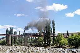 A special tourist train steaming across the Kraai River bridge near Lady Grey in 1979 | |
| Country | South Africa |
|---|---|
| Province | Eastern Cape |
| Part of | Orange River |
| Source | |
| - location | Witteberge |
| - elevation | 2,500 m (8,202 ft) |
| - coordinates | 30°42′31″S 27°27′51″E / 30.70861°S 27.46417°E |
| Mouth | |
| - location | South of Lady Grey, South Africa |
| - elevation | 1,400 m (4,593 ft) |
| - coordinates | 30°54′20″S 27°07′28″E / 30.90556°S 27.12444°ECoordinates: 30°54′20″S 27°07′28″E / 30.90556°S 27.12444°E |
 | |
The Karnmelkspruit is a tributary of the Kraai River in the Senqu area in the northeastern part of the Eastern Cape. It rises to the south of Wittenberg near Lesotho and flows as a stream southwestward through valleys and gorges east of the town of Lady Grey and further south to where it joins the Kraai River at 30°54′20″S 27°07′58″E / 30.90556°S 27.13278°E.
The river is crossed by a historical railway line (at 30°48′01″S 27°14′48″E / 30.80028°S 27.24667°E), and the Jan Kemp Vorster Bridge (1973) carries car traffic over the river in the direction of Barkly East, about 50 km away.
See also
- List of rivers of South Africa
- List of reservoirs and dams in South Africa