Karakoram
| Karakoram | |
|---|---|
|
| |
| Highest point | |
| Peak | K2 |
| Elevation | 8,611 m (28,251 ft) |
| Coordinates | 35°52′57″N 76°30′48″E / 35.88250°N 76.51333°E |
| Geography | |
|
<div style="padding:2px 2px 5px 2px;> 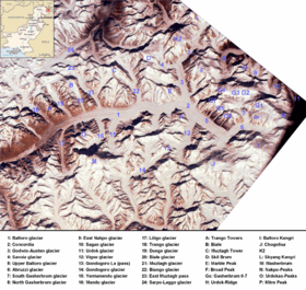 Highest Karakoram peaks as seen from International Space Station | |
| Countries | Pakistan, India and China |
| States/Provinces | Gilgit–Baltistan, Ladakh and Xinjiang |
| Range coordinates | 36°N 76°E / 36°N 76°ECoordinates: 36°N 76°E / 36°N 76°E |
| Borders on | Ladakh Range, Pamirs and Hindu Raj (Hindu Kush) |

The Karakoram, or Karakorum ( Sanskrit: काराकोरम्; Hindi: काराकोरम; Urdu: سلسلہ کوہ قراقرم; simplified Chinese: 喀喇昆仑山脉; traditional Chinese: 喀喇崑崙山脈; pinyin: Kālǎkūnlún Shānmài; , Kārākōram; Balti: ཁརན ཨ ཀུརམ Kharan-a-Kuram Uyghur: كاراكورم), is a large mountain range spanning the borders between Pakistan, India and China, located in the regions of Gilgit–Baltistan (Pakistan), Ladakh (India), and Xinjiang region (China). A subrange of the Hindu Kush Himalayan Range,[1] it is one of the Greater Ranges of Asia. The Karakoram is home to the highest concentration of peaks over 8000m in height to be found anywhere on earth,[2] including K2, the second highest peak in the world at 8,611 m (28,251 ft).
The range is about 500 km (311 mi) in length, and is the most heavily glaciated part of the world outside the polar regions. The Siachen Glacier at 76 kilometres (47 mi) and the Biafo Glacier at 63 kilometres (39 mi) rank as the world's second and third longest glaciers outside the polar regions.[3]
The Karakoram is bounded on the northeast by the edge of the Tibetan Plateau, and on the north by the Pamir Mountains. The southern boundary of the Karakoram is formed, west to east, by the Gilgit, Indus, and Shyok Rivers, which separate the range from the northwestern end of the Himalaya range proper as these rivers converge southwestward towards the plains of Pakistan.
The Tashkurghan National Nature Reserve and the Pamir Wetlands National Nature Reserve in the Karalorun and Pamir mountains have been nominated for inclusion in UNESCO in 2010 by the National Commission of the People's Republic of China for UNESCO and has tentatively been added to the list.[4]
Name
Karakoram is a Turkic term meaning black gravel. The name was first applied by local traders to the Karakoram Pass.[5] Early European travellers, including William Moorcroft and George Hayward, started using the term for the range of mountains west of the pass, although they also used the term Muztagh (meaning, "Ice Mountain") for the range now known as Karakoram.[5][6] Later terminology was influenced by the Survey of India, whose surveyor Thomas Montgomerie in the 1850s gave the labels K1 to K6 (K for Karakoram) to six high mountains visible from his station at Mount Haramukh in Kashmir.
Exploration
Due to its altitude and ruggedness, the Karakoram is much less inhabited than parts of the Himalayas further east. European explorers first visited early in the 19th century, followed by British surveyors starting in 1856.
The Muztagh Pass was crossed in 1887 by the expedition of Colonel Francis Younghusband[7] and the valleys above the Hunza River were explored by General Sir George K. Cockerill in 1892. Explorations in the 1910s and 1920s established most of the geography of the region.
The name Karakoram was used in the early 20th century, for example by Kenneth Mason,[5] for the range now known as the Baltoro Muztagh. The term is now used to refer to the entire range from the Batura Muztagh above Hunza in the west to the Saser Muztagh in the bend of the Shyok River in the east.
Geology and glaciers
The Karakoram is in one of the world's most geologically active areas, at the boundary between two colliding continents.
A significant part, 28-50% of the Karakoram Range is glaciated, compared to the Himalaya (8-12%) and Alps (2.2%).[8] Mountain glaciers may serve as an indicator of climate change, advancing and receding with long-term changes in temperature and precipitation.[9] Karakoram glaciers are mostly stagnating or enlarging,[10][11] because, unlike in the Himalayas, many Karakoram glaciers are covered in a layer of rubble which insulates the ice from the warmth of the sun. Where there is no such insulation, the rate of retreat is high.[12]
The Karakoram during the Ice Age
In the last ice age, a connected series of glaciers stretched from western Tibet to Nanga Parbat, and from the Tarim basin to the Gilgit District.[13][14][15] To the south, the Indus glacier was the main valley glacier, which flowed 120 kilometres (75 mi) down from Nanga Parbat massif to 870 metres (2,850 ft) elevation.[13][16] In the north, the Karakoram glaciers joined those from the Kunlun Mountains and flowed down to 2,000 metres (6,600 ft) in the Tarim basin.[15][17]
While the current valley glaciers in the Karakorum reach a maximum length of 76 kilometres (47 mi), several of the ice-age valley glacier branches and main valley glaciers, had lengths up to 700 kilometres (430 mi). During the Ice age, the glacier snowline was about 1,300 metres (4,300 ft) lower than today.[15][16]
Highest peaks

The notable peaks of the Karakoram are:
- K2 — 8,611 metres (28,251 ft)
- Gasherbrum I — 8,080 metres (26,510 ft)
- Broad Peak — 8,051 metres (26,414 ft)
- Gasherbrum II — 8,035 metres (26,362 ft)
- Gasherbrum III — 7,952 metres (26,089 ft)
- Gasherbrum IV — 7,925 metres (26,001 ft)
- Distaghil Sar — 7,885 metres (25,869 ft)
- Kunyang Chhish — 7,852 metres (25,761 ft)
- Masherbrum I — 7,821 metres (25,659 ft)
- Batura I — 7,795 metres (25,574 ft)
- Rakaposhi — 7,788 metres (25,551 ft)
- Batura II — 7,762 metres (25,466 ft)
- Kanjut Sar — 7,760 metres (25,460 ft)
- Saltoro Kangri — 7,742 metres (25,400 ft)
- Batura III — 7,729 metres (25,358 ft)
- Saser Kangri — 7,672 metres (25,171 ft)
- Chogolisa — 7,665 metres (25,148 ft)
- Haramosh Peak — 7,397 metres (24,268 ft)
- Momhil Sar — 7,343 metres (24,091 ft)
- Baintha Brakk — 7,285 metres (23,901 ft)
- Muztagh Tower — 7,273 metres (23,862 ft)
The majority of the highest peaks are in the Gilgit–Baltistan region of Pakistan. Baltistan has more than 100 mountain peaks exceeding 6,100 metres (20,000 ft) height from sea level.
K-names

- K1: Masherbrum
- K2
- K3: Broad Peak
- K4: Gasherbrum II
- K5: Gasherbrum I
- K6: Baltistan Peak
- K7: 6,934 m peak near Charakusa Valley
- K9: approx. 7,000 m peak near Trango Towers
- K10: Saltoro Kangri I
- K11: Saltoro Kangri II
- K12: subsidiary peak of Saltoro Kangri
- K22: Saser Kangri I
Subranges

The naming and division of the various subranges of the Karakoram is not universally agreed upon. However, the following is a list of the most important subranges, following Jerzy Wala.[18] The ranges are listed roughly west to east.
- Batura Muztagh
- Rakaposhi-Haramosh Mountains
- Spantik-Sosbun Mountains
- Hispar Muztagh
- South Ghujerab Mountains
- Panmah Muztagh
- Wesm Mountains
- Masherbrum Mountains
- Baltoro Muztagh
- Saltoro Mountains
- Siachen Muztagh
- Rimo Muztagh
- Saser Muztagh
Passes

From west to east
- Kilik Pass
- Mintaka Pass
- Khunjerab Pass (the highest paved international border crossing at 4,693 m (15,397 ft))
- Shimshal Pass
- Mustagh Pass
- Karakoram Pass
- Sasser Pass
The Khunjerab Pass is the only motorable pass across the range. The Shimshal Pass (which does not cross an international border) is the only other pass still in regular use.
Cultural references
The Karakoram mountain range has been referred to in a number of novels and movies. Rudyard Kipling refers to the Karakorum mountain range in his novel Kim, which was first published in 1900. Marcel Ichac made a film titled Karakoram, chronicling a French expedition to the range in 1936. The film won the Silver Lion at the Venice Film Festival of 1937. Greg Mortenson details the Karakoram, and specifically K2 and the Balti, extensively in his book Three Cups of Tea, about his quest to build schools for children in the region. In the Gatchaman TV series, the Karakoram range houses Galactor's headquarters.
See also
- Karakoram Highway
- List of mountain ranges of the world
- List of highest mountains (a list of mountains above 7,200 m (23,600 ft))
- Mount Imeon
Notes
- ↑ "Hindu Kush Himalayan Region". ICIMOD. Retrieved 17 October 2014.
- ↑ BBC, Planet Earth, "Mountains", Part Three
- ↑ Tajikistan's Fedchenko Glacier is 77 kilometres (48 mi) long. Baltoro and Batura Glaciers in the Karakoram are 57 kilometres (35 mi) long, as is Bruggen or Pio XI Glacier in southern Chile. Measurements are from recent imagery, generally supplemented with Russian 1:200,000 scale topographic mapping as well as Jerzy Wala,Orographical Sketch Map: Karakoram: Sheets 1 & 2, Swiss Foundation for Alpine Research, Zurich, 1990.
- ↑ "Karakorum-Pamir". unesco. Retrieved 16 February 2013.
- ↑ 5.0 5.1 5.2 Mason, Kenneth (1928). Exploration of the Shaksgam Valley and Aghil ranges, 1926. pp. 72ff. ISBN 9788120617940.
- ↑ Close C, Burrard S, Younghusband F et al. (1930). "Nomenclature in the Karakoram: Discussion". The Geographical Journal (Blackwell Publishing) 76 (2): 148–158. doi:10.2307/1783980. JSTOR 1783980.
- ↑ French, Patrick. (1994). Younghusband: The Last Great Imperial Adventurer, pp. 53, 56-60. HarperCollinsPublishers, London. Reprint (1995): Flamingo. London. ISBN 0-00-637601-0.
- ↑ Gansser (1975). Geology of the Himalayas. London: Interscience Publishers.
- ↑ Mughal, Muhammad Aurang Zeb. 2013. "Pamir Alpine Desert and Tundra." Robert Warren Howarth (ed.), Biomes & Ecosystems, Vol. 3. Ipswich, MA: Salem Press, pp. 978-980.
- ↑ Gallessich, Gail (2011). "Debris on certain Himalayan glaciers may prevent melting". sciencedaily.com. Retrieved January 30, 2011.
- ↑ Collins, Nick. "Himalayan glaciers growing despite global warming". Daily Telegraph. Retrieved October 11, 2012.
- ↑ Veettil, B.K. (2012). "A Remote sensing approach for monitoring debris-covered glaciers in the high altitude Karakoram Himalayas". International Journal of Geomatics and Geosciences 2 (3): 833–841.
- ↑ 13.0 13.1 Kuhle, M. (1988). "The Pleistocene Glaciation of Tibet and the Onset of Ice Ages- An Autocycle Hypothesis.Tibet and High Asia. Results of the Sino-German Joint Expeditions (I)". GeoJournal 17 (4): 581–596. doi:10.1007/BF00209444.
- ↑ Kuhle, M. (2006). "The Past Hunza Glacier in Connection with a Pleistocene Karakorum Ice Stream Network during the Last Ice Age (Würm)". In Kreutzmann, H.; Saijid, A. Karakoram in Transition. Karachi, Pakistan: Oxford University Press. pp. 24–48.
- ↑ 15.0 15.1 15.2 Kuhle, M. (2011). "The High Glacial (Last Ice Age and Last Glacial Maximum) Ice Cover of High and Central Asia, with a Critical Review of Some Recent OSL and TCN Dates". In Ehlers, J.; Gibbard, P.L.; Hughes, P.D. Quaternary Glaciation - Extent and Chronology, A Closer Look. Amsterdam: Elsevier BV. pp. 943–965. (glacier maps downloadable)
- ↑ 16.0 16.1 Kuhle, M. (2001). "Tibet and High Asia (VI): Glaciogeomorphology and Prehistoric Glaciation in the Karakoram and Himalaya". GeoJournal 54 (1–4): 109–396. doi:10.1023/A:1021307330169.
|chapter=ignored (help) - ↑ Kuhle, M. (1994). "Present and Pleistocene Glaciation on the North-Western Margin of Tibet between the Karakoram Main Ridge and the Tarim Basin Supporting the Evidence of a Pleistocene Inland Glaciation in Tibet. Tibet and High Asia. Results of the Sino-German and Russian-German Joint Expeditions (III)". GeoJournal (Dordrecht, Boston, London: Kluwer) 33 (2/3): 133–272. doi:10.1007/BF00812877.
- ↑ Jerzy Wala, Orographical Sketch Map of the Karakoram, Swiss Foundation for Alpine Research, Zurich, 1990.
References
- Curzon, George Nathaniel. 1896. The Pamirs and the Source of the Oxus. Royal Geographical Society, London. Reprint: Elibron Classics Series, Adamant Media Corporation. 2005. ISBN 1-4021-5983-8 (pbk); ISBN 1-4021-3090-2 (hbk).
- Kreutzmann, Hermann, Karakoram in Transition: Culture, Development, and Ecology in the Hunza Valley, Oxford, Oxford University Press, 2006. ISBN 978-0-19-547210-3
- Mortenson, Greg and Relin, David Oliver. 2008. Three Cups of Tea. Penguin Books Ltd. ISBN 978-0-14-103426-3 (pbk); Viking Books ISBN 978-0-670-03482-6 (hbk); Tantor Media ISBN 978-1-4001-5251-3 (MP3 CD).
- Kipling, Rudyard 2002. Kim (novel); ed. by Zohreh T. Sullivan. New York: W. W. Norton & Company. ISBN 039396650X—This is the most extensive critical modern edition with footnotes, essays, maps, etc.
External links
| Wikimedia Commons has media related to Karakoram. |
- Blankonthemap The Northern Kashmir Website
- Pakistan's Northern Areas dilemma
- Great Karakorams
- Karakorams.com : Travel and Trekking in the karakorams
| ||||||||||||||
| ||||||||||||||||||||||||||||||||||
| ||||||||||||||||||||||||||||||||||