Kapelle
For other uses, see Kapelle (disambiguation).
| Kapelle | |||
|---|---|---|---|
| Municipality | |||
|
Kapelle town centre | |||
| |||
.svg.png) Location in Zeeland | |||
| Coordinates: 51°29′N 3°57′E / 51.483°N 3.950°ECoordinates: 51°29′N 3°57′E / 51.483°N 3.950°E | |||
| Country | Netherlands | ||
| Province | Zeeland | ||
| Government[1] | |||
| • Body | Municipal council | ||
| • Mayor | Anton Stapelkamp (CDA) | ||
| Area[2] | |||
| • Total | 49.63 km2 (19.16 sq mi) | ||
| • Land | 37.13 km2 (14.34 sq mi) | ||
| • Water | 12.50 km2 (4.83 sq mi) | ||
| Elevation[3] | 1 m (3 ft) | ||
| Population (May 2014)[4] | |||
| • Total | 12,522 | ||
| • Density | 337/km2 (870/sq mi) | ||
| Demonym | Kapellenaar | ||
| Time zone | CET (UTC+1) | ||
| • Summer (DST) | CEST (UTC+2) | ||
| Postcode | 4420–4429 | ||
| Area code | 0113 | ||
| Website |
www | ||
_huizen_op_kerkplein.JPG)

.svg.png)
Kapelle (![]() pronunciation ) is a municipality and a town in the southwestern Netherlands on Zuid-Beveland.
pronunciation ) is a municipality and a town in the southwestern Netherlands on Zuid-Beveland.
Population centers
- Biezelinge
- Eversdijk
- Kapelle
- Schore
- Wemeldinge
Topography
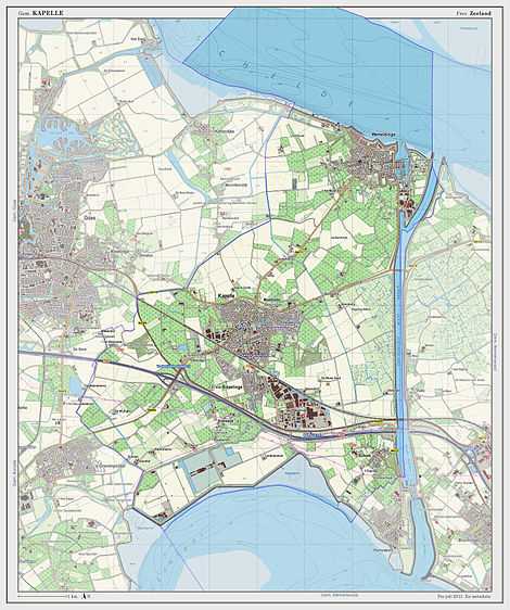
Dutch Topographic map of the municipality of Kapelle, 2013.
Transport
Railway station: Kapelle-Biezelinge.
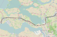
Passenger railway Vlissingen to Roosendaal (part of line 11), with stations (grouped by municipality, bolded), and official station abbreviations:
- Vlissingen (vs)
- Vlissingen Souburg (vss)
- Middelburg (mdb)
- Arnemuiden (arn)
- Goes (gs)
- Kapelle-Biezelinge (bzl)
- Kruiningen-Yerseke (krg) (mun. Reimerswaal)
- Krabbendijke (kbd)
- Rilland-Bath (rb)
- Bergen op Zoom (bgn)
- Roosendaal (rsd)
Famous people
- Annie M.G. Schmidt - famous writer was born in Kapelle
- Jan Peter Balkenende - Dutch prime minister was born in Biezelinge
- Jan Kees de Jager - Dutch minister of Finance
International relations
Twin towns — Sister cities
Kapelle is twinned with:
-
 Skoczów, Poland
References
- ↑ "Samenstelling" [Members] (in Dutch). Gemeente Kapelle. Retrieved 11 December 2013.
- ↑ "Kerncijfers wijken en buurten" [Key figures for neighbourhoods]. CBS Statline (in Dutch). CBS. 2 July 2013. Retrieved 12 March 2014.
- ↑ "Postcodetool for 4421AA". Actueel Hoogtebestand Nederland (in Dutch). Het Waterschapshuis. Retrieved 11 December 2013.
- ↑ "Bevolkingsontwikkeling; regio per maand" [Population growth; regions per month]. CBS Statline (in Dutch). CBS. 26 June 2014. Retrieved 24 July 2014.
External links
 Media related to Kapelle, Zeeland at Wikimedia Commons
- Official website
 |
Tholen Eastern Scheldt |
| ||
| Goes | |
|||
| ||||
| | ||||
| Borsele | Western Scheldt Hulst |
Reimerswaal |
| |||||||||||||
