Kaohsiung
| Kaohsiung 高雄市 | |||
|---|---|---|---|
| Special municipality | |||
| Kaohsiung City | |||
|
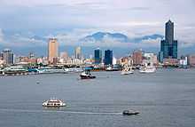
Clockwise from top: Kaohsiung skyline, Kaohsiung Confucius Temple, Liuhe Night Market, National Stadium, Port of Kaohsiung, Central Park Station | |||
| |||
| Nickname(s): The Harbor City (Gangdu), The Maritime Capital, The Waterfront City | |||
.svg.png) Kaohsiung City shown within the Taiwan islands | |||
 Satellite image of Kaohsiung | |||
| Coordinates: 22°38′N 120°16′E / 22.633°N 120.267°ECoordinates: 22°38′N 120°16′E / 22.633°N 120.267°E | |||
| Country |
| ||
| Region | Southern Taiwan | ||
| City seat |
Lingya District and Fongshan District | ||
| Government | |||
| • Mayor | Kiku Chen (DPP) | ||
| • Deputy Mayor | Liu Shih-fang[1] | ||
| Area | |||
| • Total | 2,946.2527 km2 (1,137.5545 sq mi) | ||
| Rank 4 | |||
| Elevation | 9 m (30 ft) | ||
| Population (December 2014) | |||
| • Total | 2,778,992 | ||
| • Density | 940/km2 (2,400/sq mi) | ||
| Rank 2 | |||
| Time zone | NST (UTC+08:00) | ||
| Postal code | 800–852 | ||
| Area code(s) | (0)7 | ||
| ISO 3166 code | TW–KHH | ||
| Districts | 38 | ||
| Flower | Chinese hibiscus (Hibiscus rosa-sinensis) | ||
| Tree | Cotton Tree (Bombax ceiba) | ||
| Website | www.kcg.gov.tw/EN | ||


| Kaohsiung City | |||||||||||||||||||||||||||||||
|
"Kaohsiung" written in Traditional Chinese | |||||||||||||||||||||||||||||||
| Chinese name | |||||||||||||||||||||||||||||||
|---|---|---|---|---|---|---|---|---|---|---|---|---|---|---|---|---|---|---|---|---|---|---|---|---|---|---|---|---|---|---|---|
| Chinese | 高雄市 | ||||||||||||||||||||||||||||||
| Literal meaning | High Bravery | ||||||||||||||||||||||||||||||
| |||||||||||||||||||||||||||||||
| Japanese name | |||||||||||||||||||||||||||||||
| Kanji | 高雄市 | ||||||||||||||||||||||||||||||
| Kana | たかおし | ||||||||||||||||||||||||||||||
| |||||||||||||||||||||||||||||||

Kaohsiung City (Chinese: 高雄市; pinyin: Gāoxióngshì; Pe̍h-ōe-jī: Ko-hiông-chhī; old names: Takao, Takow, Takau) is a special municipality in Taiwan. Located in southern-western Taiwan and facing the Taiwan Strait, it is by area the largest municipality, at 2,947.62 km2 (1,138.08 sq mi), and second most populous (by urban area) with a population of approximately 2.77 million. Since its start at 17th century, Kaohsiung has grown from a small trading village, into the political, economic, transportation, manufacturing, refining, shipbuilding, and industrial center of southern Taiwan. It is a global city with sufficiency as categorized by Globalization and World Cities Research Network in 2012.[2]
The Kaohsiung International Airport serving the city is the third largest airport in Taiwan. The Port of Kaohsiung is the largest harbor in Taiwan, but not officially part of Kaohsiung City. The southern terminal of the Freeway 1 is in Kaohsiung. For north-south travel on railway, the city is served by the Taiwan Railways Administration stations of TRA Western Line and Pingtung Line. The Taiwan High Speed Rail also provides fast and frequent railway connection to Taipei. The Kaohsiung Mass Rapid Transit, the city's subway system, launched in early 2008. Kaohsiung was the host city of the World Games 2009, a multi-sport event primarily composed of sports not featured in the Olympic Games. The city is also home to the Republic of China Navy fleet headquarters and academy.
Etymology and names
Hoklo immigrants to the area during the 16th and 17th centuries called it Takau (Chinese: 打狗; pinyin: Dǎgǒu; Pe̍h-ōe-jī: Táⁿ-káu). The surface meaning of the associated Chinese characters was "beat the dog".
According to one theory, the name Takau originates from the aboriginal Siraya language and translates as "bamboo forest". According to another theory, the name evolved via metathesis from the name of the Makatao tribe, who inhabited the area at the time of European and Hoklo settlement. On a linguistic basis, the Makatao are considered to have been part of a greater Siraya tribe.
During the Dutch colonization of southern Taiwan, the area was known as Tancoia to the western world for a period of about three decades. In 1662, the Dutch were expelled by the Kingdom of Tungning government, founded by Ming loyalists of Koxinga. His son, Zheng Jing, renamed the village Wannian Zhou (simplified Chinese: 万年州; traditional Chinese: 萬年州; pinyin: Wànnián Zhōu; literally: "region of ten thousand years") in 1664.
The name of "Takau" was restored in the late 1670s, when the town expanded dramatically with immigrants from mainland China, and was kept through Taiwan's cession to the Japanese Empire in 1895. In his 1903 general history of Taiwan, US Consul to Formosa (1898–1904) James W. Davidson relates that "Takow" was already a well-known name in English.[3] However, in 1920, the Japanese changed the name to 高雄 (romaji: Takao) and administered the area under Takao Prefecture. While the new name, as pronounced in Japanese, sounded more or less the same as the old name spoken in Hokkien, the different characters changed the literal meaning of the name from "beating dog" to "high bravery".
After the Republic of China took control of Taiwan, the government continued to use the characters 高雄, but as they promoted Standard Chinese, the official romanization became "Kaohsiung" (Hanyu Pinyin: Gāoxióng).
The name Takau remains the official name of the city in Austronesian languages of Taiwan such as Rukai, although these are not widely spoken in the city. The name also remains popular locally in the naming of businesses, associations, and events.
History
The written history of Kaohsiung can be traced back to the early 17th century, through archeological studies have found signs of human activity in the region from as long as 7000 years ago. Prior to the 17th century, the region was inhabited by the Makatau clan of the Siraya aboriginal tribe, who settled on what they named Ta-kau Isle (translated to 打狗嶼 by Ming Chinese explorers); "Takau" meaning "bamboo forest" in the aboriginal language. Dutch settlers colonizing Taiwan in 1624 referred to the region as Tankoya and named the harbor Tancoia. The first Chinese records of the region were written in 1603 by Chen Di, a member of Ming admiral Shen You-rong's expedition to rid the waters around Taiwan and Penghu of pirates. In his report on the "Eastern Barbarian Lands" (Dong Fan Ji), Chen Di referred to a Ta-kau Isle:
| “ | It is unknown when the barbarians (Taiwanese aborigines) arose on this island in the ocean beyond Penghu, but they are present at Keeong Harbor (nowaday's Budai, Chiayi), the bay of Galaw (Anping, Tainan), Laydwawan (Tainan City), Yaw Harbor (Cheting, Kaohsiung), Takau Isle (Kaohsiung City), Little Tamsui (Donggang, Pingtung), Siangkeykaw (Puzi, Chiayi), Gali forest (Jiali District, Tainan), the village of Sabah (Tamsui, Taipei), and Dwabangkang (Bali, New Taipei City). | ” |
Early history

The earliest evidence of human activity in the Kaohsiung area dates back to roughly 4700–5200 years ago. Most of the discovered remnants were located in the hills surrounding Kaohsiung Harbor, artifacts are found at nowadays' Shoushan, Longquan Temple, Taoziyuan, Zuoying old town, Zuoying, Houjing ruins, Fudingjin and Fengbitou. The prehistoric Dapenkeng, Niuchouzi, Dahu, and Niaosong civilizations were known to inhabit the region. Studies of the prehistoric ruins at Longquan Temple have shown that that civilization occurred at roughly the same times as the beginnings of the aboriginal Makatau civilization, suggesting a possible origin for the latter. Unlike some other archeological sites in the area, the Longquan Temple ruins are relatively well preserved. Prehistoric artifacts discovered have suggested that the ancient Kaohsiung Harbor was originally a lagoon, with early civilizations functioning primarily as hunter-gatherer societies. Some agricultural tools have also been discovered, suggesting that some agricultural activity was also present.
Dutch colonial period
Taiwan became a Dutch colony in 1624, after the Dutch East Indies Company was ejected from Penghu by Ming forces. At the time, Takau was already one of the most important fishing ports in southern Taiwan. The Dutch named the place Tankoya, and the harbor Tancoia. The Dutch missionary François Valentijn named Takau Mountain "Ape Berg", a name which would find its way onto European navigational charts well into the 18th century. Tankoia was located north of Ape's Hill and a few hours south from Tayouan (modern-day Anping, Tainan) by sail.[4] At the time, a wide shallow bay existed there, sufficient for small vessels. However, constant silting changed the coastline.
During this time, Taiwan was divided into five administrative districts, with Takau belonging to the southernmost district. In 1630, the first large scale immigration of Han Chinese to Taiwan began due to famine in Fujian, with merchants and traders from China seeking to purchase hunting licenses from the Dutch or hide out in aboriginal villages to escape authorities in China.
Qing Dynasty

In 1684 the Qing Dynasty annexed Taiwan and renamed the town Fengshan County (Chinese: 鳳山縣; Chinese: 凤山县; pinyin: Fèngshān Xiàn), considering it a part of Taiwan Prefecture. It was first opened as a port during the 1680s and subsequently prospered fairly for generations.[5]
Empire of Japan
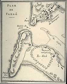
.jpg)
In 1895, Taiwan was ceded to Japan as part of the Treaty of Shimonoseki. Japan placed Taiwan under the rule of Governor-General. Administrative control of the city was moved from New Fongshan Castle to the Fongshan Sub-District of Tainan Chō (臺南廳). In November 1901, twenty Chō were established in total; Hōzan Chō (鳳山廳) was established nearby. In 1909, Hōzan Chō was abolished, and Takow was merged into Tainan Chō (臺南廳).
In 1920, during the tenure of 8th Governor-General Den Kenjirō, districts were abolished in favor of prefectures. Thus the city was administered as Takao City, Takao Prefecture, and its name in characters changed from 打狗 (Pe̍h-ōe-jī: Táⁿ-káu) to 高雄 (romaji: Takao). While the sound remained more or less the same when pronounced in Japanese, the literal meaning of the name changed from "Beating Dog" to "High Hero".
The Japanese developed Takow, especially the harbor which became the foundation of Kaohsiung to be a port city. Takow was then systematically modernized and connected to the end of North-South Railway. The city center was relocated several times during the period due to the government's development strategy.[6]
Development was initially centered on Ki-au (旗後) region but the government began laying railways, upgrading the harbor, constructing railway stations and passing new urban plans. New industries such as refinery, machinery, shipbuilding and cementing were also introduced. An important military base and industry center, the city was heavily bombed by Task Force 38 and FEAF during 1944–1945.
Republic of China


After control of Taiwan was handed over from Japan to the government of the Republic of China on 25 October 1945, Kaohsiung City and Kaohsiung County were established as a provincial city and a county of Taiwan Province respectively on 25 December 1945. The official romanization of the name came to be "Kaohsiung", based on the Wade–Giles romanization of the Mandarin reading of the kanji name.[7] Kaohsiung eventually surpassed Tainan to become the second largest city of Taiwan in the late 1970s and Kaohsiung City was upgraded from a provincial city to special municipality on July 1, 1979, by the Executive Yuan, which approved this proposal on November 19, 1979. The Kaohsiung Incident, where the government suppressed a commemoration of International Human Rights Day, occurred on December 10, 1979. Since then Kaohsiung gradually grew into a political center of the Pan-Green (DPP) population of Taiwan, in opposition to Taipei where the majority population are Kuomintang supporters. On December 25, 2010, Kaohsiung City merged with Kaohsiung County to form a larger special municipality with Lingya District and Fongshan District becoming the capital city, ending the administration of Kaohsiung County.
2014 gas explosions
On 31 July 2014, a series of gas explosions occurred in the Cianjhen and Lingya Districts of the city. 31 people were killed and more than 300 others were injured. Five roads were destroyed in an area of nearly 20 km² near the city center, making the incident the largest gas explosion in Taiwan's modern history.[8]
Geography

The city sits on the southwestern coast of Taiwan facing the Taiwan Strait, bordering Tainan City to the North, Chiayi and Nantou County to the North-west, Taitung County to its North-east and Pingtung County to the South and South-east. The downtown areas are centered on Kaohsiung Harbor with the island of Qijin on the other side of the harbor acting as a natural breakwater. The Love River (or Ai River) flows into the harbor through the Old City and downtown. Zuoying Military Harbor lies to the north of Kaohsiung Harbor and the city center. Kaohsiung's natural landmarks include the coral mountains Ape Hill, Shoushan and Mount Banping.
Climate
Located over a degree to the south of the Tropic of Cancer, the climate of Kaohsiung is tropical, specifically a tropical savanna climate (Köppen Aw), with monthly mean temperatures in the range of between 20 to 29 °C (68 to 84 °F) with relative humidity ranging between 71 and 81%.
Kaohsiung's warm climate is very much dictated to its low latitude and its location with a year-round warm sea temperature, with the Kuroshio Current passing by the coasts of southern Taiwan,[9] and the Central mountain range on the northeast blocking out the cool northeastern winds during the winter. The city therefore has a noticeably warmer climate than nearby cities located at similar latitudes such as Hong kong, Guangzhou as well as various cities further south of northern and central Vietnam, such as Hanoi. But although the climate is classified as tropical, Kaohsiung has a defined cooler season unlike most other cities in Asia classified with this climate but located closer to the equator such as Singapore or Manila. Daily maximum temperature typically exceeds 30 degrees Celsius during the warmer season (April to November) and 25 degrees Celsius during the cooler season (December to March), with the exception when cold fronts strikes during the winter months, when the daily mean temperature of the city can drop between 3-5 degrees Celsius depending on the strength of the cold front. Also, besides the high temperatures occurring during the usual summer months, daytime temperatures of inland districts of the city can often exceed above 33 degrees Celsius from mid March to late April before the onset of the monsoon season, with clear skies and southwesterly airflows. Average annual rainfall is around 1,885 millimetres (74.2 in), focused primarily from June to August. At more than 2210 hours of bright sunshine, the city is one of the sunniest areas in Taiwan.[10]
The sea temperature of Kaohsiung Harbor remains above 22 °C year-round,[11] the second highest of Southern Taiwan after Liuqiu island, an island just off the coast of southern Kaohsiung with average monthly sea temperatures maintaining above 25 °C year-round.[12] According to recent records, the average temperature of the city has rose around 1 degree Celsius over the past 3 decades, from about 24.2 °C in 1983 to around 25.2 °C by 2012.
Notably, Kaohsiung is the only global city, or any city with significancy in economic activities and a population of over 1 million of Political East Asia that features a tropical climate,[13] as any other cities that feature a tropical climate in this portion of Asia, which are all located either at other parts of southern and southeastern Taiwan or the southern half of Hainan Island, are minor municipalities with population under 5 hundred thousand and very minor economic activities.[14]
| Climate data for Kaohsiung City | |||||||||||||
|---|---|---|---|---|---|---|---|---|---|---|---|---|---|
| Month | Jan | Feb | Mar | Apr | May | Jun | Jul | Aug | Sep | Oct | Nov | Dec | Year |
| Record high °C (°F) | 31.7 (89.1) |
33.3 (91.9) |
33.4 (92.1) |
34.9 (94.8) |
35.5 (95.9) |
37.2 (99) |
37.1 (98.8) |
36.1 (97) |
37.6 (99.7) |
35.3 (95.5) |
34.4 (93.9) |
33.0 (91.4) |
37.6 (99.7) |
| Average high °C (°F) | 23.9 (75) |
24.7 (76.5) |
26.8 (80.2) |
29.1 (84.4) |
30.8 (87.4) |
31.7 (89.1) |
32.4 (90.3) |
31.9 (89.4) |
31.5 (88.7) |
30.0 (86) |
27.9 (82.2) |
25.1 (77.2) |
28.82 (83.87) |
| Daily mean °C (°F) | 19.3 (66.7) |
20.3 (68.5) |
22.6 (72.7) |
25.4 (77.7) |
27.5 (81.5) |
28.6 (83.5) |
29.2 (84.6) |
28.7 (83.7) |
28.2 (82.8) |
26.7 (80.1) |
24.1 (75.4) |
20.7 (69.3) |
25.11 (77.21) |
| Average low °C (°F) | 15.7 (60.3) |
16.7 (62.1) |
19.2 (66.6) |
22.4 (72.3) |
24.8 (76.6) |
26.0 (78.8) |
26.4 (79.5) |
26.1 (79) |
25.6 (78.1) |
24.0 (75.2) |
21.0 (69.8) |
17.2 (63) |
22.1 (71.8) |
| Record low °C (°F) | 5.7 (42.3) |
6.6 (43.9) |
6.8 (44.2) |
9.8 (49.6) |
15.9 (60.6) |
18.2 (64.8) |
21.0 (69.8) |
20.8 (69.4) |
20.1 (68.2) |
14.6 (58.3) |
12.5 (54.5) |
4.4 (39.9) |
4.4 (39.9) |
| Average rainfall mm (inches) | 16.0 (0.63) |
20.5 (0.807) |
38.8 (1.528) |
69.8 (2.748) |
197.4 (7.772) |
415.3 (16.35) |
390.9 (15.39) |
416.7 (16.406) |
241.9 (9.524) |
42.7 (1.681) |
18.7 (0.736) |
16.2 (0.638) |
1,884.9 (74.21) |
| Avg. rainy days (≥ 0.1 mm) | 3.2 | 3.7 | 4.0 | 5.8 | 9.3 | 13.8 | 12.9 | 16.3 | 11.2 | 3.5 | 2.6 | 2.3 | 88.6 |
| Average relative humidity (%) | 72.7 | 73.5 | 73.2 | 75.1 | 76.9 | 80.1 | 78.7 | 80.5 | 78.9 | 75.5 | 73.3 | 71.9 | 75.9 |
| Mean monthly sunshine hours | 174.7 | 165.8 | 187.0 | 189.1 | 198.5 | 199.9 | 221.4 | 193.7 | 175.7 | 182.4 | 162.2 | 161.8 | 2,212.2 |
| Source: Central Weather Bureau (Normals 1981–2010, Extremes 1931–present)[10] | |||||||||||||
| Climate data for Kaohsiung International Airport (2010–2014 Temperatures) | |||||||||||||
|---|---|---|---|---|---|---|---|---|---|---|---|---|---|
| Month | Jan | Feb | Mar | Apr | May | Jun | Jul | Aug | Sep | Oct | Nov | Dec | Year |
| Record high °C (°F) | 30 (86) |
32 (90) |
33 (91) |
34 (93) |
35 (95) |
36 (97) |
36 (97) |
35 (95) |
37 (99) |
33 (91) |
33 (91) |
32 (90) |
37 (99) |
| Average high °C (°F) | 25.0 (77) |
26.6 (79.9) |
28.0 (82.4) |
29.2 (84.6) |
31.0 (87.8) |
32.0 (89.6) |
32.6 (90.7) |
32.0 (89.6) |
32.0 (89.6) |
30.2 (86.4) |
28.6 (83.5) |
25.0 (77) |
29.35 (84.84) |
| Daily mean °C (°F) | 19.8 (67.6) |
21.4 (70.5) |
23.6 (74.5) |
25.4 (77.7) |
27.6 (81.7) |
28.8 (83.8) |
29.2 (84.6) |
28.5 (83.3) |
28.0 (82.4) |
26.4 (79.5) |
24.6 (76.3) |
20.6 (69.1) |
25.33 (77.58) |
| Average low °C (°F) | 15.4 (59.7) |
17.2 (63) |
19.6 (67.3) |
23.2 (73.8) |
24.8 (76.6) |
26.4 (79.5) |
26.4 (79.5) |
25.5 (77.9) |
25.0 (77) |
23.4 (74.1) |
21.2 (70.2) |
16.8 (62.2) |
22.08 (71.73) |
| Record low °C (°F) | 9 (48) |
12 (54) |
13 (55) |
14 (57) |
20 (68) |
22 (72) |
24 (75) |
23 (73) |
22 (72) |
18 (64) |
13 (55) |
10 (50) |
9 (48) |
| Source: Wunderground[15] | |||||||||||||
Cityscape

Demographics
| 1927 | 49,000 | |
| 1937 | 102,200 | |
| 1947 | 168,008 | |
| 1957 | 388,848 | |
| 1967 | 669,146 | |
| 1977 | 1,041,364 | |
| 1987 | 1,342,797 | |
| 1997 | 1,436,142 | |
| 2007 | 1,520,555 | |

As of June 2014, Kaohsiung city has a population of 2,777,296 people, the second highest of Taiwan after New Taipei city and a population density of 942.22 people per square kilometer. Within the city, Fengshan district is the most populated district with a population of 353,142 people, while Xinxin district is the most densely populated district with a population density of 26,709 people per square kilometer.
Ethnic composition
Han Chinese
As of most Taiwanese cities or counties, the majority population are of Han Chinese descendants. the Hans are then divided into 3 subgroups, Hoklo, Hakka and Waishengren. The Hoklo and Waishengren mostly lives in flatland townships and the city centre, while the majority of the Hakka population lives in the suburbs or rural townships of the northeastern hills.
Taiwanese Aborigines
The Taiwanese Aborigines of Kaohsiung, who belong to various ethnic groups which speak different languages belonging to the Austronesian language family similar/related to those of Maritime Southeast Asia and Oceania, mostly live in the mountain townships such as Taoyuan or Namasia. The main aboriginal groups living within the city include the Bunun, Rukai, Tsou and the Kanakanavus.
New residents (新住民)
As of December 2010, Kaohsiung city hosts around 21,000 foreign spouses. Within around 12,353 are Mainland Chinese, 4,244 are Vietnamese, around 800 Japanese and Indonesians and around 4,000 other Asians or foreigners from Europe or the Americas.
Foreign workers in Kaohsiung
As of April 2013, Kaohsiung hosts 35,074 foreign workers who mainly works as factory workers or foreign maids (Not including foreign specialists such as teachers and other professionals). Within around half of which are Indonesians, and the other half being workers from other Southeast Asian countries mainly from Vietnam, the Philippines or Thailand.
Economy


Intensive settlement began in earnest in the late 17th century, when the place was known as Ki-au (旗後). Opened in 1863 as a treaty port, subsidiary to the port of Anping farther north on the coast, Kaohsiung became a customs station in 1864 and then gradually became an important port for the southern Taiwan coastal plain.
Kaohsiung's real economic and strategic importance began under Japanese rule (1895–1945). The Japanese needed a good port in southern Taiwan to serve those designated areas that were to become a major source of raw materials and food for Japan, and Kaohsiung was chosen. It became the southern terminus of the main north-south railway line, and from 1904 to 1907 extensive harbor works were undertaken. In 1920 the port was given the name Takao and the area became a municipality in 1920.
Before and during World War II it handled a growing share of Taiwan's agricultural exports to Japan, and was also a major base for Japan's campaigns in Southeast Asia and the Pacific, and extremely ambitious plans for the construction of a massive modern port were drawn up. Toward the end of the war, too, the Japanese promoted some industrial development at Kaohsiung, establishing an aluminum industry based on the abundant hydroelectric power produced by the Sun Moon Lake project in the mountains.
After it came under Chinese Nationalist administration in 1945, Kaohsiung developed rapidly. The port, badly damaged in World War II, was restored. It also became a fishing port for boats sailing to Philippine and Indonesian waters. Largely because of its climate, Kaohsiung has overtaken Keelung as Taiwan's major port.
Today as a major international port and industrial city in the southwest of the country, Kaohsiung is the most rapidly developing urban center of Taiwan. With an area of 2,946 km2, it has a large natural harbor, with the entrance in recent years being expanded, rock-excavated, and dredged.
As an exporting center, Kaohsiung serves the rich agricultural interior of southern Taiwan, as well as the mountains of the southeast. Major raw material exports include rice, sugar, bananas, pineapples, peanuts (groundnuts) and citrus fruits. The 2,200 hectare Linhai Industrial Park, on the waterfront, was completed in the mid-1970s and includes a steel mill, shipyard, petrochemical complex, and other industries. The city has an oil refinery, aluminum and cement works, fertilizer factories, sugar refineries, brick and tile works, and salt-manufacturing and papermaking plants. Designated an export-processing zone in the late 1970s, Kaohsiung has succeeded in attracting foreign investment to process locally purchased raw materials for export. There is also a large canning industry that processes both fruit and fish.
The ongoing Nansing Project is an ambitious plan to reclaim 250 hectares of land along the coast by 2011.[16] The Kaohsiung Harbor Bureau plans to buy 49 hectares of the reclaimed land to establish a solar energy industrial district which would be in the harbor's free trade zone.[16]
The gross domestic product (GDP) in nominal terms of Kaohsiung City is estimated to be around US$45 billion, and US$90 billion for the metropolitan region. As of 2008, the GDP per capita in nominal terms is approximately US$24,000.
Culture
Tourism


Main landmarks of Kaohsiung city includes the Tuntex Sky Tower, the ferris wheel of the Kaohsiung Dream Mall, the Kaohsiung Arena and the Kaohsiung Harbor. The newly developed city is also known for having a large number of shopping streets, organized night markets and newly developed leisure parks such as the Pier-2 Art Center or the E-DA Theme Park.
Natural attractions of the city includes Shoushan (Monkey mountain), the Love River, Qijin, the bay of Xiziwan, the Dapingding Tropical Botanical Garden and the Yushan National Park at the northeastern tip of the city. The city also features various historical attractions such as the Old City of Zuoying, a historical town built during the early 17th century, the Former British Consulate at Takao built during the late 19th century or various sugar and crop factories built during the Japanese occupation of Taiwan.
Natural attractions
Kaohsiung city includes a wide range of different natural attractions due to its large size with geographical differences in different parts of the city, as it is bordered by the Central mountain range in the northeast and the warm South China Sea to the west and southwest. The year-round warm climate allows coral reefs to grow along the coasts around Kaohsiung harbor, with Shoushan mountain being a small mountain completely made up of coral reefs and calcium carbonate, while the mountainous districts in the northeast include one of the highest peaks in East Asia, Mount Yushan. Other notable natural attractions includes the Mount Banping, Lotus Lake and the Dongsha Atoll National Park, which is currently inaccessible by the public due to military occupation.
Historical sites

A large number of historical sites and monuments were left in the city after the colonization of the Dutch in the 17th century, the Qing dynasty during the 18th and 19th century and the Japanese empire from the late 19th century to the mid 20th century, the city government has been protecting the various sites and monuments from further damage and large amounts of the historical monuments were opened to the public since the early 1980s. Notable historical sites includes the Former British Consulate at Takao, the Cemetery of Zhenghaijun and the Cihou Lighthouse, one of the oldest lighthouses of the city.
Museums


As a rather newly developed city, comparing to its neighbor Tainan, Kaohsiung city is endowed with some of the widest roads in the country and the most organized usage of space, since the development of the city mostly occurred during the Japanese occupation of Taiwan. The large space therefore enabled the new government to build large amounts of museums of all sorts, from astronomy to history, art, and science and technology.
This is a stark contrast to Kaohsiung city's northern neighbor Tainan, as Tainan city features some of the narrowest roads and least modern architecture in the country although it is considered as one of the five special municipalities of Taiwan, due to Tainan city's long history which therefore fixed the shape of the city centre. Popular museums in the city includes the Kaohsiung Museum of Fine Arts, Taiwan Sugar Museum, Kaohsiung Museum of History and the Meinong Hakka Culture Museum.
Parks and Zoos


As the largest municipality in Taiwan, Kaohsiung has a number of mostly newly built leisure areas/parks. This includes parks, zoos, pavilions and a number of wharfs and piers. Notable parks or pavilions in the city includes the Central Park of Kaohsiung, Fo Guang Shan, the Dragon and Tiger Pagodas, the Love Pier, Singuang Ferry Wharf and the Kaohsiung Fisherman's Wharf.
Others

Kaohsiung is well known of having numerous amounts of large and organized night markets, such as the Liuhe Night Market and Ruifeng Night Market, as well as having the biggest night market in Taiwan, the Kaisyuan Night Market which opened in late 2013. Other attractions includes the Dome of Light of Kaohsiung MRT's Formosa Boulevard Station, the Kaohsiung Mosque and the Tower of Light of Sanmin District.
Languages
The majority population of Kaohsiung can communicate in both Taiwanese Hokkien and Mandarin Chinese, some elders whom grew up during the Japanese colonization of Taiwan can communicate in Japanese, while most of the younger population has basic English skills.
Since the spread of Mandarin Chinese after the Nationalist Government retreated to Taiwan in 1949, Hakka and various Formosan languages are gradually no longer spoken within the new generation and many Formosan languages are therefore classified as moribund or endangered languages by the United Nation. Nowadays, only elder Hakka people living in Meinong, Liouguei, Shanlin and Jiaxian districts can communicate in the Hakka language and elder Taiwanese aborigines living mostly in the rural districts of Namasia and Taoyuan can communicate with the aboriginal languages. Therefore recently the Taiwanese government established Special affairs committee for both the Aboriginals (原住民事務委員會) and the Hakkas (客家事務委員會) to protect the language, culture and the rights of the two minorities.
Arts
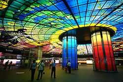
Kaohsiung has rich resources of the ocean, mountains and forests, take shape a diverse combination and different communities, the formation of a very active and multi-faceted nature of art and culture in the streets of Kaohsiung, everywhere you can see the beauty and grace of its public infrastructure, public art and city architecture.The field of public transport in Kaohsiung show a city of aesthetics. Unique design from MRT station to the city's public works of art, city space into an art gallery. "Dome light" in the concourse of Formosa Boulevard Station of Kaohsiung MRT is one of the world's largest public glass works of art, and it is the public art chanticleer representative works in Kaohsiung.[17] The city also has the Urban Spotlight Arcade spanning along the street in Cianjin District.
Religion
The religious population of Kaohsiung is mainly divided into five main religious groups, Buddhist, Taoist, Muslim and Christian (Catholicism and Protestantism). As of 2002, Kaohsiung city has 1414 Buddhist or Taoist temples, the most within the country and 306 churches.
Buddhism
Buddhism is one of the major religion in Taiwan, with over 35% of Taiwan's population are Buddhist. The same applies to Kaohsiung city. Kaohsiung also hosts the largest Buddhist temple in Taiwan, the Foguangshan Temple.
Taoism
Around 33% of the Taiwanese population are Taoist, making it the second largest religion of Taiwan. Most people who believe in Taoism also ascribe to Buddhism at the same time, as the differences and boundaries between the two religions are not always clear in Taiwanese culture. As Kaohsiung city was once a fishing port, many residents of the area worships the sea goddess of Mazu, a Taoist goddess, praying for the safety of the fisherman. The Qijin Mazu Temple of Kaohsiung is the oldest Mazu temple within the country with a history of over 300 years.
Christianity
Christianity is a growing religion in Taiwan, the religion was first brought onto the island when the Dutch and Spanish colonized Taiwan during the 17th century, mostly to the aboriginals. Kaohsiung currently hosts around 56,000 Christians.
Islam
Besides the majority population of Buddhist and Taoist, Kaohsiung also includes a rather small population of Muslims. During the Chinese Civil War, some 20,000 Muslims, mostly soldiers and civil servants, fled mainland China with the Kuomintang to Taiwan. While during the 1980s, another few thousands of Muslims from Myanmar and Thailand, whom are mostly descendants of Nationalist soldiers who fled Yunnan as a result of the communist takeover, migrated to Taiwan in search of a better life, resulting in an increase of Muslim population within the country. More recently, with the rise of Indonesian workers working in Taiwan, an estimated number of 88,000 Indonesian Muslims currently lives in the country, in addition to the existing 53,000 Taiwanese Muslims. Combining all demographics, Taiwan hosts around 140,000 Muslim population, with around 25,000 living in Kaohsiung. Kaohsiung Mosque is the largest mosque in Kaohsiung and the main gathering site of Muslims within the city.
 Foguangshan Temple |
 Qijing Tianhou Temple |


Politics
Government
Kaohsiung is sometimes seen as the political mirror image of Taipei. While northern Taiwan leans towards the Pan-Blue Coalition in the state-level elections, southern Taiwan leaned towards the Pan-Green Coalition since the late 1990s, and Kaohsiung is no exception. Frank Hsieh of the Democratic Progressive Party was reelected twice as Mayor of Kaohsiung, where he was widely credited for transforming the city from an industrial sprawl into an attractive modern metropolis. Hsieh resigned from the office of mayor to take up the office of Premier of the Republic of China in 2005. The last municipal election, held on December 9, 2006, resulted in a victory for the Democratic Progressive Party's candidate Chen Chu, the first elected female mayor of special municipality in Taiwan, defeating her Kuomintang rival and former deputy mayor, Huang Chun-ying.
 Kaohsiung District Court |
 Kaohsiung mayor Chen Chu |
.JPG)
Subdivisions
Kaohsiung is directly divided into 38 districts and each district is divided into villages. There are a total of 651 villages in which each village is subdivided into neighborhoods (鄰). There are 18,584 neighborhoods in Kaohsiung City. Lingya and Fengshan Districts are the administrative centers of the city while Lingya and Xinxin Districts are the two most densely populated districts of the city. Kaohsiung has the most numbers of districts among other special municipalities in Taiwan.
- Note: For the inconsistency of the romanization systems in Taiwan. This table was made in a sortable form, contains both Hanyu Pinyin (the official standard of the central government of ROC),[19] and Tongyong Pinyin (the official standard of the Kaohsiung City Government). The major order of districts referred to the code of administrative area.
|
 Kaohsiung City administrative divisions map .svg.png) Kaohsiung City's population density 2009 Fengshan Jiaxian Liugui Nanzi Qiaotou Qishan Xiaogang Ziguan Qianzhen Qijin Tainan City | ||||||||||||||||||||||||||||||||||||||||||||||||||||||||||||||||||||||||||||||||||||||||||||||||||||||||||||||||||||||||||||||||||||||||||||||||||||||||||||||||||||||||||||||||||||||||||||||||||||||||||||||||||||||||||||||||||||||||||||||||||||||||||||||||||||||||||||||||||||||||||||||||||||||||||||||||||||||||||||||||||||||||||||||||||||||||
Part of South China Sea Islands are administered by Kaohsiung City as parts of Qijin District:
- Taiping Island (Chinese: 太平島; pinyin: Tàipíng dǎo) and Zhongzhou Reef (Chinese: 中洲礁; pinyin: Zhōngzhōu jiāo) in the Spratly Islands
- Dongsha Islands or Pratas Islands (Chinese: 東沙群島; pinyin: Dōngshā Qúndǎo)
Transportation
Port of Kaohsiung

A major port, through which pass most of Taiwan's marine imports and exports, is located at the city but is not managed by the city government.Also known as the "Harbour Capital" of Taiwan, Kaohsiung has always had a strong link with the ocean and maritime transportation. Ferries play a key role in everyday transportation, and often play the role that buses do in other cities, especially for transportation across the harbour. With five terminals and 23 berths, the Port of Kaohsiung is Taiwan's largest container port and the 6th largest in the world.[20] In 2007 the port reached its handling capacity with a record trade volume of 10.2 million twenty-foot equivalent units (TEU).[21] A new container terminal is under construction, increasing future handling capacity by 2 million TEU by 2013.[21]
The Port of Kaohsiung is not officially a part of Kaohsiung City, instead it is administrated by Kaohsiung Port Authority, under Ministry of Transportation. There is a push for Kaohsiung City to annex the Port of Kaohsiung in order to facilitate better regional planning.
Kaohsiung is one of the biggest ports in the world for importing shark fins, sold at high prices in the restaurants and shops of Taiwan and China. They are brought in from overseas and are placed out to dry in the sun on residential rooftops near the port.
Kaohsiung International Airport

Kaohsiung City is also home to Taiwan's second largest international airport, the Kaohsiung International Airport, located in Siaogang District near the city's center. Although Kaohsiung International Airport is one of the two major international airports of Taiwan, serving passengers of the entire southern and southeastern part of the country, the size of the airport is relatively small with short runways compared to other major airports of Taiwan due to its age and its location near the city center, making large aircraft such as the Airbus A380 or a fully loaded Boeing 747 impossible to land in the airport. As a result, plans for runway expansion or building a new airport in replacement has been proposed but no major progress has taken place.
Rapid transit


Kaohsiung Mass Rapid Transit opened for revenue service in March 2008. A light rail line (Circular Line) that circles central Kaohsiung City is under construction and will open in 2015.
Notably, two of Kaohsiung's MRT stations, Formosa Boulevard Station and Central Park Station, were ranked among the top 50 most beautiful subway systems in the world by Metrobits.org in 2011.[22] In 2012, the two stations respectively are ranked as the 2nd and the 4th among the top 15 most beautiful subway stops in the world by BootsnAll.[23]
Circular Light Rail

The Circular Light Rail Line (a.k.a. Kaohsiung LRT, Kaohsiung Tram) for Kaohsiung City is a planned light rail line. Construction of Phase I began in June 2013, and is scheduled to be in operation by mid-2015.
A temporary light rail system for demonstration purposes, with just 2 stations, was built in the Central Park in 2004, using Melbourne D2 Tram cars from Siemens. As it was simply for demonstration purposes, it was closed soon after, and is no longer operational.
Railway
The city is served by the Taiwan Railways Administration's Western Line and Pingtung Line. Taiwan High Speed Rail also serves Kaohsiung City via its New Zuoying Station in northern Kaohsiung City. The station is an underground station, replacing the old ground level station. Additionally, these two stations are also be served by Red line of Kaohsiung Rapid Transit System when the line opened for revenue service in early 2008.
Sports

Kaohsiung has Southern Taiwan region's most comprehensive sports facilities, as well as the country's largest stadium. Kaohsiung National Stadium (the Main Stadium of 2009 World Games) and Kaohsiung Arena as the representative of sports facilities in Kaohsiung. National Stadium is Taiwan's largest international-class stadium, maximum capacity is 55,000 seats.
Kaohsiung hosted the 2009 World Games. Nearly 6,000 athletes, officials, coaches, referees and others from 103 countries participated in the 2009 Kaohsiung World Games. Kaohsiung in 2007, 2009 and 2011 for three consecutive years, the number of gold medals and total medals of the National Games were the first place in the country.
Education


Kaohsiung has a number of colleges and junior colleges offering training in commerce, education, maritime technology, medicine, modern languages, nursing, and technology. As well as various international schools offering education for foreign students or local students who would like to study aboard for university in the future and 8 national military schools, including the three major military academies of the country the Republic of China Military Academy, Republic of China Naval Academy and Republic of China Air Force Academy.
Universities
- Kaohsiung Medical University (高雄醫學大學)
- National Kaohsiung First University of Science and Technology (國立高雄第一科技大學)
- National Kaohsiung Normal University (國立高雄師範大學)
- National Kaohsiung University of Applied Sciences (國立高雄應用科技大學)
- National Kaohsiung Marine University (國立高雄海洋科技大學)
- National Kaohsiung University of Hospitality and Tourism (國立高雄餐旅大學)
- National Sun Yat-sen University (國立中山大學)
- National University of Kaohsiung (國立高雄大學)
- I-Shou University (義守大學)
- Wenzao Ursuline University of Languages (文藻外語大學)
- Shih Chien University, Kaohsiung Campus (實踐大學高雄校區)
High Schools and Junior High Schools
- Kaohsiung Municipal Kaohsiung Senior High School (高雄市立高雄高級中學)
- Municipal Kaohsiung Girls' Senior High School (高雄市立女子高級中學)
- Affiliated Senior High School of National Kaohsiung Normal University
International Schools
- Kaohsiung American School
- I-Shou International School
- Morrison Academy Kaohsiung
- Kivam Junior High School
- Dominican International School Kaohsiung
Military Academies
- Republic of China Military Academy (中華民國陸軍軍官學校)
- Republic of China Naval Academy (中華民國海軍軍官學校)
- Republic of China Air Force Academy (中華民國空軍軍官學校)
- Republic of China Air Force Institute of Technology (中華民國空軍航空技術學院)
- Republic of China Marine Corps school (中華民國海軍陸戰隊學校)
- Republic of China Army Infantry school (中華民國陸軍步兵學校)
- Chung-cheng Armed Forces Preparatory school (中正國防幹部預備學校)
(Note: The lists above are not complete lists)
Conferences and events
The Kaohsiung Exhibition Center, built by the Kaohsiung City Government, was opened on 14 April 2014. It includes an exhibition space for 1,500 booths, and a convention hall for 2,000 pax.
The center hosted the Taiwan International Boat Show in May 2014.[24] Another conference and event-related venue is the newly renovated International Convention Center Kaohsiung in 2013.
Sister cities and twin towns
Kaohsiung is twinned with the following locations.
|
|
|
Relative location
 |
|
|
| |
| Taiwan Strait (South China Sea) | |
| ||
| ||||
| | ||||
| |
See also
- Administrative divisions of the Republic of China
- Kaohsiung City Council
- Kaohsiung City Government
- List of cities in Taiwan
- Taipei
References
- ↑ Shih, Hsiu-chuan (2013-07-12). "Sister-city agreement falls apart in hours". Taipei Times. Retrieved 2013-07-27.
- ↑ "The World According to GaWC 2012". Lboro.ac.uk. 2014-01-13. Retrieved 2014-02-01.
- ↑ Davidson, James W. (1903). The Island of Formosa, Past and Present : history, people, resources, and commercial prospects : tea, camphor, sugar, gold, coal, sulphur, economical plants, and other productions. London and New York: Macmillan. p. iii. OCLC 1887893. OL 6931635M.
- ↑ Campbell, William (1903). "Explanatory Notes". Formosa under the Dutch: described from contemporary records, with explanatory notes and a bibliography of the island. London: Kegan Paul. p. 548. OCLC 644323041.
- ↑ "History of Kaohsiung". HotelTravel.com. 1999.
- ↑ "Discover Kaohsiung > History". Welcome to Kaohsiung City. 2013.
- ↑ What's in changing a name? Taiwan Journal Vol. XXVI No. 19 May 15, 2009 "...while name Kaohsiung is technically the Mandarin pronunciation of the Japanese written version of a Holo Taiwanese rendition of an old aboriginal name..."
- ↑ "Many dead in Taiwan city gas blasts". Taiwan's News.Net. Retrieved 2 August 2014.
- ↑ "Taiwan sea temperatures of February 2012". Central Weather Bureau.
- ↑ 10.0 10.1 "Climate". Central Weather Bureau.
- ↑ "Kaohsiung Average Sea Temperatures". Central Weather Bureau.
- ↑ "Liuqiu island Average Sea Temperatures". Central Weather Bureau.
- ↑ "The World According to GaWC 2012". GaWC.
- ↑ Cities of East Asia
- ↑ "Climate". Wunderground.
- ↑ 16.0 16.1 "Kaohsiung City to open solar energy industrial zone". Focus Taiwan News Channel. 2010-06-27. Retrieved 2010-07-09.
- ↑ "Art&Culture Kaohsiung City Government". Kcg.gov.tw. Retrieved 2013-07-27.
- ↑ "Taiwan Yearbook 2006". Government of Information Office. 2006. Archived from the original on 2007-07-08. Retrieved 2007-09-01.
- ↑ "Glossary of Names for Admin Divisions" (PDF). placesearch.moi.gov.tw. Ministry of Interior of the ROC. Retrieved 18 March 2015.
- ↑ Review of Maritime Transport 2004. New York: United Nations. 2005. ISBN 92-1-112645-2.
|first1=missing|last1=in Authors list (help) - ↑ 21.0 21.1 Dale, Jamie (2008-01-17). "Kaohsiung container port hits full capacity". Lloyd's List Daily Commercial News (Informa Australia). p. 16.
- ↑ "A guide to the fifty most beautiful subway systems in the world". Metrobits.org. 2011-12-01.
- ↑ "15 of the Most Beautiful Subway Stops in the World". BootsnAll. Retrieved 2012-01-29.
- ↑ "Kaohsiung’s new venue". TTGmice. Retrieved 18 January 2013.
External links
- Kaohsiung City Government official website (Chinese)
- Kaohsiung City Government official website (English)
| ||||||||||||||||||||||
| |||||||||||||||||||||

| ||||||||||||||||||||||||||||||||||
| ||||||