Kansas, Ohio
| Kansas, Ohio | |
|---|---|
| Unincorporated community | |
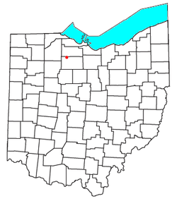 Location of Kansas, Ohio | |
| Coordinates: 41°14′42″N 83°17′05″W / 41.24500°N 83.28472°WCoordinates: 41°14′42″N 83°17′05″W / 41.24500°N 83.28472°W | |
| Country | United States |
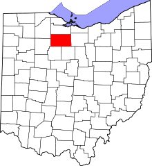
| State | Ohio |
| County | Seneca |
| Township | Liberty |
| Time zone | Eastern (EST) (UTC-5) |
| • Summer (DST) | EDT (UTC-4) |
| ZIP codes | 44841 |
Kansas is a census-designated place in northwestern Liberty Township, Seneca County, Ohio, United States.[1] Although it is unincorporated, it has a post office, with the ZIP code of 44841.[2] It is located along State Route 635.[3]
Kansas was platted in early 1855 along a line of the Lake Erie and Louisville Railroad.[4] A short distance south of the community on State Route 635 is the Michaels Farm, which has been named a historic site.[5] Kansas is the named hometown of the Lakota Local School District, though none of the schools in the district are in the community.
References
- ↑ U.S. Geological Survey Geographic Names Information System: Kansas, Ohio
- ↑ Zip Code Lookup
- ↑ DeLorme. Ohio Atlas & Gazetteer. 7th ed. Yarmouth: DeLorme, 2004, 37. ISBN 0-89933-281-1.
- ↑ Lang, W. History of Seneca County, from the Close of the Revolutionary War to July, 1880. Springfield: Transcript, 1880, 550.
- ↑ "National Register Information System". National Register of Historic Places. National Park Service. 2010-07-09.
| |||||||||||||||||||||||||||||||||