Kano River
| Kano River 狩野川 | |
|---|---|
|
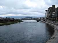
Kano River at Numazu | |
| Origin | Amagi Mountains |
| Mouth | Suruga Bay |
| Basin countries | Japan |
| Length | 46 km (29 mi) |
| Source elevation | 2,000 m (6,600 ft) |
| Mouth elevation | 0 m (0 ft) |
| Avg. discharge | 17.88 m3/s (631 cu ft/s) |
| Basin area | 853 km2 (329 sq mi) |
The Kano River (狩野川 Kano-gawa) is a 1st class river in Shizuoka Prefecture of ceniral Japan. It is 46 km long and has a watershed of 853 km².
The Kano River rises from Mount Amagi in central Izu Peninsula and follows a generally northern path into Suruga Bay at Numazu. The Izu Peninsula is characterized by heavy rainfall, and the Kano River has a steep gradient with rapid flow and is prone to flooding. During a powerful typhoon in September 1958 (later designated the "Kanogawa Typhoon"), the river caused heavy damage to towns along its banks, resulting in 1269 deaths.
The Jōren Falls, one of Japan's Top 100 Waterfalls is located in the upper reaches of the Kano River.
External links
35°04′47″N 138°51′17″E / 35.079645°N 138.854833°ECoordinates: 35°04′47″N 138°51′17″E / 35.079645°N 138.854833°E (confluence with Ibi River)