Kangazha
| Kangazha | |
|---|---|
| Village | |
 Kangazha Location in Kerala, India | |
| Coordinates: 9°33′00″N 76°43′05″E / 9.550°N 76.718°ECoordinates: 9°33′00″N 76°43′05″E / 9.550°N 76.718°E | |
| Country |
|
| State | Kerala |
| District | Kottayam |
| Elevation | 81 m (266 ft) |
| Population (2001) | |
| • Total | 171,271 (7km2) |
| Languages | |
| • Official | Malayalam, English |
| Time zone | IST (UTC+5:30) |
| PIN | 686541(pathanadu po),686555(kanjirappara) |
| Telephone code | 91 481 249 |
| Vehicle registration | KL 33- |
Kangazha is a panchayath and village in the Changanacherry Taluk of the Kottayam District of Kerala State in India. It is located 21 kilometers east of Kottayam. It lies midway between the backwaters of Western Kerala and the misty mountains of the Western Ghats.
Adjacent areas
- West - Karukachal
- North - Pampady
- East - Manimala and Cheruvally
- South - Ezhumattoor and vaipur
The nearest railway stations are Kottayam (21 km) and Changanacherry (22 km), and the nearest airport is Cochin Airport (Nedumbasserry) about 100 km away. Kangazha is on the Changanassery - Vazhoor state highway which joins Kottayam - Kumaly NH at Pulickalkavala on the north side and on the Karukachal Manimala road on the east side.
Meaning of Kangazha
Kanva,the father of Shakuntala had visited Kangazha and he stoned the Sivalinga in Kangazha. And thus the term Kanvaya which was referred to point this incident become the name of this village and later Kanvaya had reestablished as Kangazha.
Major religious places
- Town Masjid Pathanadu, (Managed by kangazha puthoorpally juma-ath)
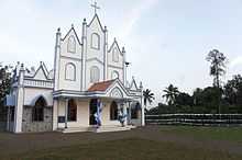
- St.Peter's C.S.I Church, Kangazha - The first Christian church in Kangazha (Estd.1864)
Economy
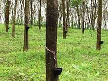
The economy of Kangazha is primarily from agriculture. Kangazha is one of the rubber producing villages in Kerala because the hilly terrain, high humidity and good rain make it suitable for rubber cultivation. Other major crops are coconut, tapioca and pepper. NRIs are also another major source of income.
Notable people
- Kanam EJ(1926–1982), Kanam Rajendran, ex-MLA
- P N M ANSARY valanjattil,(elephants owners kottayam district president,state committee member,planter,businessman
- Late Advocate A.K.P Pillai (Aranatu Elakattu)
- P.I. Shajahan Payyampallil,(kerala sawmill owners association State Member,businessman)